Saint-Souplet geodata
Saint-Souplet (Hauts-de-France) is a populated place; located in France in Europe/Paris (GMT+2) time zone. With population of 1,349 people, there are 6819 cities with bigger population in this country. Compared to other cities in France, 93.9% of cities are located further ↓South; 64.5% of cities are located further ←West and 50.8% of cities have lower elevation than Saint-Souplet. Note1
Administrative division(s):
- Level 1: Hauts-de-France
- Level 2: Nord
- Level 3: Arrondissement de Cambrai
- Level 4: Saint-Souplet


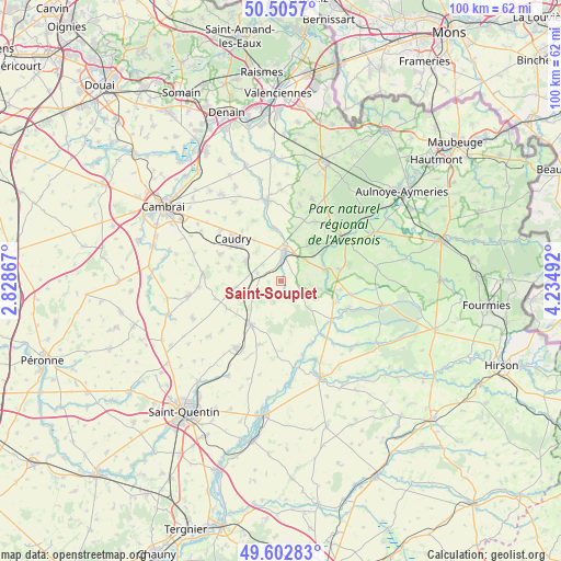
Saint-Souplet GPS coordinates[2]
50° 3' 23.004" North, 3° 31' 54.444" East
| Map corner | latitude | longitude |
|---|---|---|
| Upper-left | 50.5057°, | 2.82867° |
| Center: | 50.05639°, | 3.53179° |
| Lower-right: | 49.60283°, | 4.23492° |
| Map W x H: | 100.4×100.4 km | = 62.4×62.4mi |
| max Lat: | 51.07786° ⇑6.1% North |
| Saint-Souplet: | 50.05639° |
| min Lat: | ⇓93.9% South 41.3874° |
| min Long | Saint-Souplet | max Long |
| -5.08615° | 3.53179° | 9.52242° |
| W 64.5%⇐ | ⇒35.5% E |
Elevation
Elevation of Saint-Souplet is 135 m = 443 ft, and this is 58.7 m = 193 ft below average elevation for this country.
| Max E: |
2333 m = 7654 ft | 49.2% |
| Avg. | 193.7 m = 635 ft | |
| Saint-Souplet | 135 m = 443 ft | |
Min E: |
-1 m = -3 ft | 50.8% |
See also: France elevation on elevation.city.
Geographical zone
Saint-Souplet is located in North temperate zone (between Tropic of Cancer and the Arctic Circle). Distance of this North polar circle is 1835.4 km =1140.5 mi to North.| Distance of | km | miles | from Saint-Souplet |
|---|---|---|---|
| North Pole | 4441.3 | 2759.7 | to North |
| Arctic Circle | 1835.4 | 1140.5 | to North |
| Tropic Cancer | 2959.8 | 1839.1 | to South |
| Equator | 5565.7 | 3458.4 | to South |


Nearby cities:
15 places around Saint-Souplet: (largest is in red/bold)
• Bazuel
5.7 km =3.5 mi,  47°
47°
• Bertry
7.2 km =4.5 mi,  298°
298°
• Bohain-en-Vermandois
9.5 km =5.9 mi,  216°
216°
• Busigny
5.2 km =3.2 mi,  241°
241°
• Catillon-sur-Sambre
8.1 km =5 mi,  76°
76°
• Honnechy
4.6 km =2.9 mi,  288°
288°
• Inchy
8.8 km =5.5 mi,  326°
326°
• Maretz
8.2 km =5.1 mi,  261°
261°
• Mennevret
8 km =5 mi,  167°
167°
• Montigny-en-Cambrésis
9.4 km =5.8 mi, 294°
• Ors
8.8 km =5.5 mi,  56°
56°
• Pommereuil
7.7 km =4.8 mi,  36°
36°
• Troisvilles
7 km =4.3 mi,  320°
320°
• Vaux-Andigny
3.9 km =2.4 mi,  195°
195°
• Wassigny
6.8 km =4.2 mi,  134°
134°
Sources, notices
• [Note1] Compared only with cities in France existing in our database
• [Src1] Map data: © OpenStreetMap contributors (CC-BY-SA)
• [Src2] Other city data from geonames.org with taken over terms of usage.
• [Src3] Geographical zone / Annual Mean Temperature by Robert A. Rohde @ Wikipedia
