Bohain-en-Vermandois geodata
Bohain-en-Vermandois (Hauts-de-France) is a populated place; located in France in Europe/Paris (GMT+2) time zone. With population of 6,299 people, there are 1574 cities with bigger population in this country. Compared to other cities in France, 93.5% of cities are located further ↓South; 63.8% of cities are located further ←West and 51.9% of cities have lower elevation than Bohain-en-Vermandois. Note1
Administrative division(s):
- Level 1: Hauts-de-France
- Level 2: Département de l'Aisne
- Level 3: Arrondissement de Saint-Quentin
- Level 4: Bohain-en-Vermandois
Current local time in Bohain-en-Vermandois:
06:08 AM, WednesdayDifference from your time zone: hours


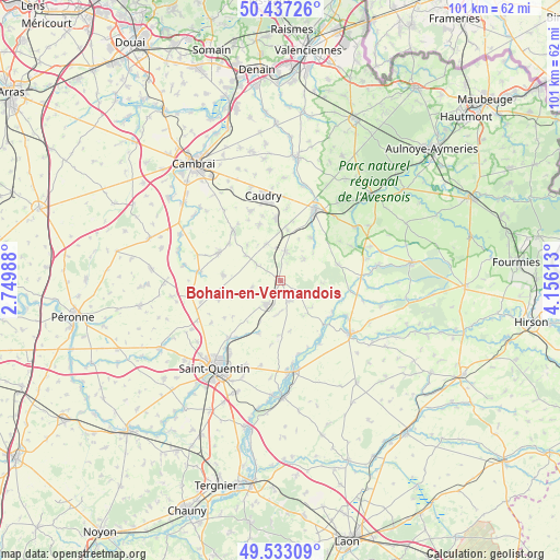
Bohain-en-Vermandois GPS coordinates[2]
49° 59' 14.28" North, 3° 27' 10.8" East
| Map corner | latitude | longitude |
|---|---|---|
| Upper-left | 50.43726°, | 2.74988° |
| Center: | 49.9873°, | 3.453° |
| Lower-right: | 49.53309°, | 4.15613° |
| Map W x H: | 100.5×100.5 km | = 62.4×62.4mi |
| max Lat: | 51.07786° ⇑6.5% North |
| Bohain-en-Vermandois: | 49.9873° |
| min Lat: | ⇓93.5% South 41.3874° |
| min Long | Bohain-en-Verma | max Long |
| -5.08615° | 3.453° | 9.52242° |
| W 63.8%⇐ | ⇒36.2% E |
Elevation
Elevation of Bohain-en-Vermandois is 139 m = 456 ft, and this is 54.7 m = 179 ft below average elevation for this country.
| Max E: |
2333 m = 7654 ft | 48.1% |
| Avg. | 193.7 m = 635 ft | |
| Bohain-en-Vermandois | 139 m = 456 ft | |
Min E: |
-1 m = -3 ft | 51.9% |
See also: France elevation on elevation.city.
Geographical zone
Bohain-en-Vermandois is located in North temperate zone (between Tropic of Cancer and the Arctic Circle). Distance of this North polar circle is 1843.1 km =1145.2 mi to North.| Distance of | km | miles | from Bohain-en-Vermandois |
|---|---|---|---|
| North Pole | 4449 | 2764.5 | to North |
| Arctic Circle | 1843.1 | 1145.2 | to North |
| Tropic Cancer | 2952.1 | 1834.3 | to South |
| Equator | 5558.1 | 3453.6 | to South |


Nearby cities:
15 places around Bohain-en-Vermandois: (largest is in red/bold)
• Brancourt-le-Grand
5.2 km =3.2 mi,  256°
256°
• Busigny
5.3 km =3.3 mi,  10°
10°
• Fonsomme
10.4 km =6.5 mi,  201°
201°
• Fresnoy-le-Grand
5.1 km =3.2 mi,  209°
209°
• Honnechy
9.2 km =5.7 mi, 8°
• Maretz
6.9 km =4.3 mi,  338°
338°
• Mennevret
7.3 km =4.5 mi,  91°
91°
• Montbrehain
7.8 km =4.8 mi,  252°
252°
• Prémont
5.4 km =3.4 mi,  305°
305°
• Saint-Souplet
9.5 km =5.9 mi,  36°
36°
• Seboncourt
4.2 km =2.6 mi,  156°
156°
• Vadencourt
10.1 km =6.3 mi,  126°
126°
• Vaux-Andigny
6 km =3.7 mi,  49°
49°
• Élincourt
8.7 km =5.4 mi,  317°
317°
• Étaves-et-Bocquiaux
5.3 km =3.3 mi,  177°
177°
Sources, notices
• [Note1] Compared only with cities in France existing in our database
• [Src1] Map data: © OpenStreetMap contributors (CC-BY-SA)
• [Src2] Other city data from geonames.org with taken over terms of usage.
• [Src3] Geographical zone / Annual Mean Temperature by Robert A. Rohde @ Wikipedia
