Montmorillon geodata
Montmorillon (Nouvelle-Aquitaine) is a seat of a third-order administrative division; located in France in Europe/Paris (GMT+2) time zone. With population of 7,960 people, there are 1217 cities with bigger population in this country. Compared to other cities in France, 60.8% of cities are located further ↑North; 70% of cities are located further →East and 56.2% of cities have higher elevation than Montmorillon. Note1
Administrative division(s):
- Level 1: Nouvelle-Aquitaine
- Level 2: Vienne
- Level 3: Arrondissement de Montmorillon
- Level 4: Montmorillon


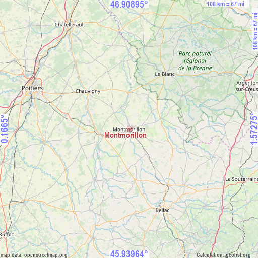
Montmorillon GPS coordinates[2]
46° 25' 35.22" North, 0° 52' 10.668" East
| Map corner | latitude | longitude |
|---|---|---|
| Upper-left | 46.90895°, | 0.1665° |
| Center: | 46.42645°, | 0.86963° |
| Lower-right: | 45.93964°, | 1.57275° |
| Map W x H: | 107.8×107.8 km | = 67×67mi |
| max Lat: | 51.07786° ⇑60.8% North |
| Montmorillon: | 46.42645° |
| min Lat: | ⇓39.2% South 41.3874° |
| min Long | Montmorillon | max Long |
| -5.08615° | 0.86963° | 9.52242° |
| W 30%⇐ | ⇒70% E |
Elevation
Elevation of Montmorillon is 113 m = 371 ft, and this is 80.7 m = 265 ft below average elevation for this country.
| Max E: |
2333 m = 7654 ft | 56.2% |
| Avg. | 193.7 m = 635 ft | |
| Montmorillon | 113 m = 371 ft | |
Min E: |
-1 m = -3 ft | 43.8% |
See also: France elevation on elevation.city.
Geographical zone
Montmorillon is located in North temperate zone (between Tropic of Cancer and the Arctic Circle). Distance of this North polar circle is 2239 km =1391.2 mi to North.| Distance of | km | miles | from Montmorillon |
|---|---|---|---|
| North Pole | 4844.9 | 3010.5 | to North |
| Arctic Circle | 2239 | 1391.2 | to North |
| Tropic Cancer | 2556.2 | 1588.3 | to South |
| Equator | 5162.1 | 3207.6 | to South |


Nearby cities:
15 places around Montmorillon: (largest is in red/bold)
• Antigny
12.1 km =7.5 mi,  354°
354°
• Brigueil-le-Chantre
17 km =10.6 mi,  101°
101°
• Béthines
15.7 km =9.8 mi,  31°
31°
• Civaux
15.7 km =9.8 mi,  277°
277°
• Gouex
15.3 km =9.5 mi,  244°
244°
• La Trimouille
13.9 km =8.6 mi,  70°
70°
• Lathus-Saint-Rémy
12.3 km =7.6 mi,  146°
146°
• Leignes-sur-Fontaine
11.4 km =7.1 mi,  321°
321°
• Lussac-les-Châteaux
11.5 km =7.1 mi,  257°
257°
• Mazerolles
14.4 km =8.9 mi, 260°
• Persac
15.5 km =9.6 mi,  233°
233°
• Saint-Germain
15.3 km =9.5 mi,  1°
1°
• Saint-Savin
15.5 km =9.6 mi,  358°
358°
• Saulgé
5.5 km =3.4 mi,  174°
174°
• Sillars
7.8 km =4.8 mi, 264°
Sources, notices
• [Note1] Compared only with cities in France existing in our database
• [Src1] Map data: © OpenStreetMap contributors (CC-BY-SA)
• [Src2] Other city data from geonames.org with taken over terms of usage.
• [Src3] Geographical zone / Annual Mean Temperature by Robert A. Rohde @ Wikipedia
