Chauvigny geodata
Chauvigny (Nouvelle-Aquitaine) is a populated place; located in France in Europe/Paris (GMT+2) time zone. With population of 7,526 people, there are 1293 cities with bigger population in this country. Compared to other cities in France, 59.5% of cities are located further ↑North; 71.9% of cities are located further →East and 65.3% of cities have higher elevation than Chauvigny. Note1
Administrative division(s):
- Level 1: Nouvelle-Aquitaine
- Level 2: Vienne
- Level 3: Arrondissement de Poitiers
- Level 4: Chauvigny


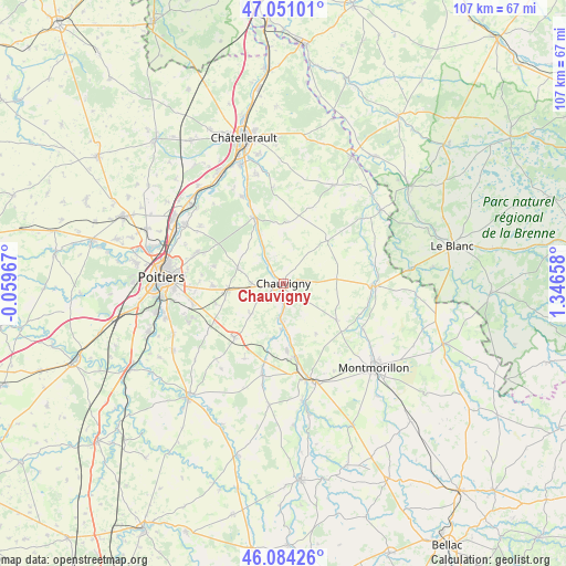
Chauvigny GPS coordinates[2]
46° 34' 11.244" North, 0° 38' 36.456" East
| Map corner | latitude | longitude |
|---|---|---|
| Upper-left | 47.05101°, | -0.05967° |
| Center: | 46.56979°, | 0.64346° |
| Lower-right: | 46.08426°, | 1.34658° |
| Map W x H: | 107.5×107.5 km | = 66.8×66.8mi |
| max Lat: | 51.07786° ⇑59.5% North |
| Chauvigny: | 46.56979° |
| min Lat: | ⇓40.5% South 41.3874° |
| min Long | Chauvigny | max Long |
| -5.08615° | 0.64346° | 9.52242° |
| W 28.1%⇐ | ⇒71.9% E |
Elevation
Elevation of Chauvigny is 89 m = 292 ft, and this is 104.7 m = 344 ft below average elevation for this country.
| Max E: |
2333 m = 7654 ft | 65.3% |
| Avg. | 193.7 m = 635 ft | |
| Chauvigny | 89 m = 292 ft | |
Min E: |
-1 m = -3 ft | 34.7% |
See also: France elevation on elevation.city.
Geographical zone
Chauvigny is located in North temperate zone (between Tropic of Cancer and the Arctic Circle). Distance of this North polar circle is 2223.1 km =1381.4 mi to North.| Distance of | km | miles | from Chauvigny |
|---|---|---|---|
| North Pole | 4829 | 3000.6 | to North |
| Arctic Circle | 2223.1 | 1381.4 | to North |
| Tropic Cancer | 2572.2 | 1598.3 | to South |
| Equator | 5178.1 | 3217.5 | to South |


Nearby cities:
15 places around Chauvigny: (largest is in red/bold)
• Archigny
11.5 km =7.1 mi,  3°
3°
• Bignoux
13.7 km =8.5 mi,  284°
284°
• Bonnes
5.3 km =3.3 mi,  316°
316°
• Bonneuil-Matours
13.7 km =8.5 mi,  335°
335°
• Buxerolles
13.3 km =8.3 mi,  293°
293°
• Jardres
6 km =3.7 mi,  268°
268°
• La Chapelle-Moulière
10.8 km =6.7 mi,  326°
326°
• La Puye
11.6 km =7.2 mi,  45°
45°
• Lavoux
9.2 km =5.7 mi, 288°
• Leignes-sur-Fontaine
12.4 km =7.7 mi,  124°
124°
• Liniers
9.3 km =5.8 mi,  299°
299°
• Pouillé
6.3 km =3.9 mi,  234°
234°
• Savigny-Lévescault
13.3 km =8.3 mi,  253°
253°
• Sèvres-Anxaumont
13.6 km =8.5 mi, 269°
• Tercé
8.5 km =5.3 mi, 226°
Sources, notices
• [Note1] Compared only with cities in France existing in our database
• [Src1] Map data: © OpenStreetMap contributors (CC-BY-SA)
• [Src2] Other city data from geonames.org with taken over terms of usage.
• [Src3] Geographical zone / Annual Mean Temperature by Robert A. Rohde @ Wikipedia
