Saint-Péray geodata
Saint-Péray (Auvergne-Rhône-Alpes) is a populated place; located in France in Europe/Paris (GMT+2) time zone. With population of 6,922 people, there are 1432 cities with bigger population in this country. Compared to other cities in France, 80.1% of cities are located further ↑North; 75.8% of cities are located further ←West and 51.2% of cities have higher elevation than Saint-Péray. Note1
Administrative division(s):
- Level 1: Auvergne-Rhône-Alpes
- Level 2: Département de l'Ardèche
- Level 3: Arrondissement de Tournon-sur-Rhône
- Level 4: Saint-Péray


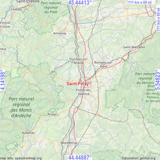
Saint-Péray GPS coordinates[2]
44° 56' 55.176" North, 4° 50' 42.36" East
| Map corner | latitude | longitude |
|---|---|---|
| Upper-left | 45.44413°, | 4.14198° |
| Center: | 44.94866°, | 4.8451° |
| Lower-right: | 44.44887°, | 5.54823° |
| Map W x H: | 110.7×110.7 km | = 68.8×68.8mi |
| max Lat: | 51.07786° ⇑80.1% North |
| Saint-Péray: | 44.94866° |
| min Lat: | ⇓19.9% South 41.3874° |
| min Long | Saint-Péray | max Long |
| -5.08615° | 4.8451° | 9.52242° |
| W 75.8%⇐ | ⇒24.2% E |
Elevation
Elevation of Saint-Péray is 128 m = 420 ft, and this is 65.7 m = 216 ft below average elevation for this country.
| Max E: |
2333 m = 7654 ft | 51.2% |
| Avg. | 193.7 m = 635 ft | |
| Saint-Péray | 128 m = 420 ft | |
Min E: |
-1 m = -3 ft | 48.8% |
See also: France elevation on elevation.city.
Geographical zone
Saint-Péray is located in North temperate zone (between Tropic of Cancer and the Arctic Circle). Distance of this Northern Tropic circle is 2391.9 km =1486.3 mi to South.| Distance of | km | miles | from Saint-Péray |
|---|---|---|---|
| North Pole | 5009.2 | 3112.6 | to North |
| Arctic Circle | 2403.4 | 1493.4 | to North |
| Tropic Cancer | 2391.9 | 1486.3 | to South |
| Equator | 4997.8 | 3105.5 | to South |


Nearby cities:
15 places around Saint-Péray: (largest is in red/bold)
• Alboussière
9.2 km =5.7 mi,  266°
266°
• Beaumont-Monteux
9.8 km =6.1 mi,  36°
36°
• Bourg-lès-Valence
3.9 km =2.4 mi,  92°
92°
• Charmes-sur-Rhône
9.5 km =5.9 mi,  184°
184°
• Cornas
1.7 km =1.1 mi,  8°
8°
• Glun
7.5 km =4.7 mi,  356°
356°
• Guilherand-Granges
2.9 km =1.8 mi,  128°
128°
• La Roche-de-Glun
7.2 km =4.5 mi, 359°
• Plats
8.4 km =5.2 mi,  323°
323°
• Portes-lès-Valence
8.4 km =5.2 mi,  164°
164°
• Saint-Marcel-lès-Valence
8.9 km =5.5 mi,  73°
73°
• Saint-Romain-de-Lerps
5.1 km =3.2 mi,  311°
311°
• Soyons
6.6 km =4.1 mi, 176°
• Toulaud
6.1 km =3.8 mi,  201°
201°
• Valence
5.7 km =3.5 mi,  116°
116°
Sources, notices
• [Note1] Compared only with cities in France existing in our database
• [Src1] Map data: © OpenStreetMap contributors (CC-BY-SA)
• [Src2] Other city data from geonames.org with taken over terms of usage.
• [Src3] Geographical zone / Annual Mean Temperature by Robert A. Rohde @ Wikipedia
