Bourg-lès-Valence geodata
Bourg-lès-Valence (Auvergne-Rhône-Alpes) is a populated place; located in France in Europe/Paris (GMT+2) time zone. With population of 19,770 people, there are 464 cities with bigger population in this country. Compared to other cities in France, 80.1% of cities are located further ↑North; 76.4% of cities are located further ←West and 54.2% of cities have lower elevation than Bourg-lès-Valence. Note1
Administrative division(s):
- Level 1: Auvergne-Rhône-Alpes
- Level 2: Département de la Drôme
- Level 3: Arrondissement de Valence
- Level 4: Bourg-lès-Valence


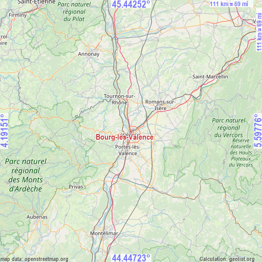
Bourg-lès-Valence GPS coordinates[2]
44° 56' 49.308" North, 4° 53' 40.668" East
| Map corner | latitude | longitude |
|---|---|---|
| Upper-left | 45.44252°, | 4.19151° |
| Center: | 44.94703°, | 4.89463° |
| Lower-right: | 44.44723°, | 5.59776° |
| Map W x H: | 110.7×110.7 km | = 68.8×68.8mi |
| max Lat: | 51.07786° ⇑80.1% North |
| Bourg-lès-Valence: | 44.94703° |
| min Lat: | ⇓19.9% South 41.3874° |
| min Long | Bourg-lès-Vale | max Long |
| -5.08615° | 4.89463° | 9.52242° |
| W 76.4%⇐ | ⇒23.6% E |
Elevation
Elevation of Bourg-lès-Valence is 147 m = 482 ft, and this is 46.7 m = 153 ft below average elevation for this country.
| Max E: |
2333 m = 7654 ft | 45.8% |
| Avg. | 193.7 m = 635 ft | |
| Bourg-lès-Valence | 147 m = 482 ft | |
Min E: |
-1 m = -3 ft | 54.2% |
See also: France elevation on elevation.city.
Geographical zone
Bourg-lès-Valence is located in North temperate zone (between Tropic of Cancer and the Arctic Circle). Distance of this Northern Tropic circle is 2391.7 km =1486.1 mi to South.| Distance of | km | miles | from Bourg-lès-Valence |
|---|---|---|---|
| North Pole | 5009.4 | 3112.7 | to North |
| Arctic Circle | 2403.5 | 1493.5 | to North |
| Tropic Cancer | 2391.7 | 1486.1 | to South |
| Equator | 4997.6 | 3105.4 | to South |


Nearby cities:
15 places around Bourg-lès-Valence: (largest is in red/bold)
• Beaumont-Monteux
8.3 km =5.2 mi,  13°
13°
• Beaumont-lès-Valence
10.2 km =6.3 mi,  158°
158°
• Châteauneuf-sur-Isère
8.3 km =5.2 mi,  21°
21°
• Cornas
4.1 km =2.5 mi,  297°
297°
• Glun
8.8 km =5.5 mi,  330°
330°
• Guilherand-Granges
2.3 km =1.4 mi,  226°
226°
• La Roche-de-Glun
8.3 km =5.2 mi, 332°
• Malissard
7 km =4.3 mi,  138°
138°
• Portes-lès-Valence
8.1 km =5 mi,  191°
191°
• Saint-Marcel-lès-Valence
5.3 km =3.3 mi,  59°
59°
• Saint-Péray
3.9 km =2.4 mi,  272°
272°
• Saint-Romain-de-Lerps
8.5 km =5.3 mi,  294°
294°
• Soyons
7.3 km =4.5 mi,  208°
208°
• Toulaud
8.2 km =5.1 mi, 228°
• Valence
2.7 km =1.7 mi,  153°
153°
Sources, notices
• [Note1] Compared only with cities in France existing in our database
• [Src1] Map data: © OpenStreetMap contributors (CC-BY-SA)
• [Src2] Other city data from geonames.org with taken over terms of usage.
• [Src3] Geographical zone / Annual Mean Temperature by Robert A. Rohde @ Wikipedia
