Saint-Pierre-le-Moûtier geodata
Saint-Pierre-le-Moûtier (Bourgogne-Franche-Comté) is a populated place; located in France in Europe/Paris (GMT+2) time zone. With population of 2,023 people, there are 4733 cities with bigger population in this country. Compared to other cities in France, 57.3% of cities are located further ↑North; 59.5% of cities are located further ←West and 70.1% of cities have lower elevation than Saint-Pierre-le-Moûtier. Note1
Administrative division(s):
- Level 1: Bourgogne-Franche-Comté
- Level 2: Département de la Nièvre
- Level 3: Arrondissement de Nevers
- Level 4: Saint-Pierre-le-Moûtier
Current local time in Saint-Pierre-le-Moûtier:
05:52 AM, WednesdayDifference from your time zone: hours


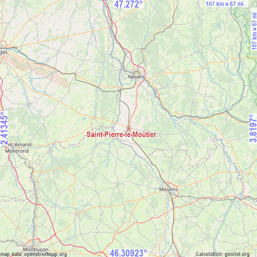
Saint-Pierre-le-Moûtier GPS coordinates[2]
46° 47' 33.972" North, 3° 6' 59.652" East
| Map corner | latitude | longitude |
|---|---|---|
| Upper-left | 47.272°, | 2.41345° |
| Center: | 46.79277°, | 3.11657° |
| Lower-right: | 46.30923°, | 3.8197° |
| Map W x H: | 107×107 km | = 66.5×66.5mi |
| max Lat: | 51.07786° ⇑57.3% North |
| Saint-Pierre-le-Moûtier: | 46.79277° |
| min Lat: | ⇓42.7% South 41.3874° |
| min Long | Saint-Pierre-le | max Long |
| -5.08615° | 3.11657° | 9.52242° |
| W 59.5%⇐ | ⇒40.5% E |
Elevation
Elevation of Saint-Pierre-le-Moûtier is 220 m = 722 ft, and this is 26.3 m = 86 ft above average elevation for this country.
| Max E: |
2333 m = 7654 ft | 29.9% |
| Saint-Pierre-le-Moûtier | 220 m 722 ft | |
| Avg. | 193.7 m = 635 ft | |
Min E: |
-1 m = -3 ft | 70.1% |
See also: France elevation on elevation.city.
Geographical zone
Saint-Pierre-le-Moûtier is located in North temperate zone (between Tropic of Cancer and the Arctic Circle). Distance of this North polar circle is 2198.3 km =1366 mi to North.| Distance of | km | miles | from Saint-Pierre-le-Moûtier |
|---|---|---|---|
| North Pole | 4804.2 | 2985.2 | to North |
| Arctic Circle | 2198.3 | 1366 | to North |
| Tropic Cancer | 2596.9 | 1613.6 | to South |
| Equator | 5202.9 | 3232.9 | to South |


Nearby cities:
15 places around Saint-Pierre-le-Moûtier: (largest is in red/bold)
• Challuy
17.6 km =10.9 mi,  7°
7°
• Chantenay-Saint-Imbert
8.3 km =5.2 mi,  142°
142°
• Chevenon
16.5 km =10.3 mi,  31°
31°
• Cuffy
19.5 km =12.1 mi,  345°
345°
• Gimouille
16.8 km =10.4 mi, 352°
• Imphy
19.3 km =12 mi, 34°
• Le Veurdre
7.1 km =4.4 mi,  235°
235°
• Livry
3.7 km =2.3 mi, 238°
• Lurcy-Lévis
15.3 km =9.5 mi, 242°
• Luthenay-Uxeloup
13 km =8.1 mi,  60°
60°
• Magny-Cours
10.4 km =6.5 mi, 14°
• Saint-Parize-le-Châtel
8.5 km =5.3 mi,  36°
36°
• Sancoins
15.4 km =9.6 mi,  286°
286°
• Sermoise-sur-Loire
18.2 km =11.3 mi,  16°
16°
• Villeneuve-sur-Allier
17.8 km =11.1 mi,  145°
145°
Sources, notices
• [Note1] Compared only with cities in France existing in our database
• [Src1] Map data: © OpenStreetMap contributors (CC-BY-SA)
• [Src2] Other city data from geonames.org with taken over terms of usage.
• [Src3] Geographical zone / Annual Mean Temperature by Robert A. Rohde @ Wikipedia
