Lurcy-Lévis geodata
Lurcy-Lévis (Auvergne-Rhône-Alpes) is a populated place; located in France in Europe/Paris (GMT+2) time zone. With population of 2,124 people, there are 4533 cities with bigger population in this country. Compared to other cities in France, 58% of cities are located further ↑North; 56.9% of cities are located further ←West and 70.1% of cities have lower elevation than Lurcy-Lévis. Note1
Administrative division(s):
- Level 1: Auvergne-Rhône-Alpes
- Level 2: Département de l'Allier
- Level 3: Arrondissement de Moulins
- Level 4: Lurcy-Lévis


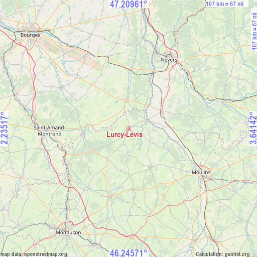
Lurcy-Lévis GPS coordinates[2]
46° 43' 47.316" North, 2° 56' 17.844" East
| Map corner | latitude | longitude |
|---|---|---|
| Upper-left | 47.20961°, | 2.23517° |
| Center: | 46.72981°, | 2.93829° |
| Lower-right: | 46.24571°, | 3.64142° |
| Map W x H: | 107.2×107.2 km | = 66.6×66.6mi |
| max Lat: | 51.07786° ⇑58% North |
| Lurcy-Lévis: | 46.72981° |
| min Lat: | ⇓42% South 41.3874° |
| min Long | Lurcy-Lévis | max Long |
| -5.08615° | 2.93829° | 9.52242° |
| W 56.9%⇐ | ⇒43.1% E |
Elevation
Elevation of Lurcy-Lévis is 220 m = 722 ft, and this is 26.3 m = 86 ft above average elevation for this country.
| Max E: |
2333 m = 7654 ft | 29.9% |
| Lurcy-Lévis | 220 m 722 ft | |
| Avg. | 193.7 m = 635 ft | |
Min E: |
-1 m = -3 ft | 70.1% |
See also: France elevation on elevation.city.
Geographical zone
Lurcy-Lévis is located in North temperate zone (between Tropic of Cancer and the Arctic Circle). Distance of this North polar circle is 2205.3 km =1370.3 mi to North.| Distance of | km | miles | from Lurcy-Lévis |
|---|---|---|---|
| North Pole | 4811.2 | 2989.5 | to North |
| Arctic Circle | 2205.3 | 1370.3 | to North |
| Tropic Cancer | 2589.9 | 1609.3 | to South |
| Equator | 5195.9 | 3228.6 | to South |


Nearby cities:
15 places around Lurcy-Lévis: (largest is in red/bold)
• Ainay-le-Château
18.9 km =11.7 mi,  263°
263°
• Bourbon-l’Archambault
18.6 km =11.6 mi,  151°
151°
• Chantenay-Saint-Imbert
18.7 km =11.6 mi,  88°
88°
• Charenton-du-Cher
22.4 km =13.9 mi,  270°
270°
• Couleuvre
6.8 km =4.2 mi,  200°
200°
• Cérilly
15.3 km =9.5 mi,  215°
215°
• Le Veurdre
8.3 km =5.2 mi,  69°
69°
• Livry
11.6 km =7.2 mi,  63°
63°
• Magny-Cours
23.5 km =14.6 mi,  43°
43°
• Ourouer-les-Bourdelins
22.7 km =14.1 mi,  335°
335°
• Saint-Bonnet-Tronçais
20.2 km =12.6 mi,  247°
247°
• Saint-Parize-le-Châtel
23.2 km =14.4 mi,  53°
53°
• Saint-Pierre-le-Moûtier
15.3 km =9.5 mi, 62°
• Sancoins
11.6 km =7.2 mi,  353°
353°
• Ygrande
19.8 km =12.3 mi,  178°
178°
Sources, notices
• [Note1] Compared only with cities in France existing in our database
• [Src1] Map data: © OpenStreetMap contributors (CC-BY-SA)
• [Src2] Other city data from geonames.org with taken over terms of usage.
• [Src3] Geographical zone / Annual Mean Temperature by Robert A. Rohde @ Wikipedia
