Luthenay-Uxeloup geodata
Luthenay-Uxeloup (Bourgogne-Franche-Comté) is a populated place; located in France in Europe/Paris (GMT+2) time zone. With population of 573 people, there are 13785 cities with bigger population in this country. Compared to other cities in France, 56.7% of cities are located further ↑North; 61.6% of cities are located further ←West and 67.8% of cities have lower elevation than Luthenay-Uxeloup. Note1
Administrative division(s):
- Level 1: Bourgogne-Franche-Comté
- Level 2: Département de la Nièvre
- Level 3: Arrondissement de Nevers
- Level 4: Luthenay-Uxeloup


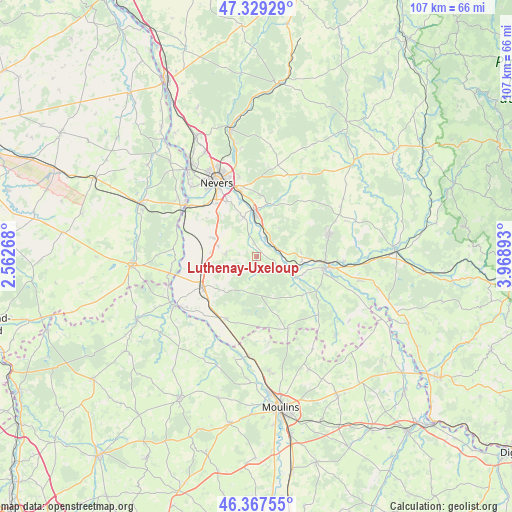
Luthenay-Uxeloup GPS coordinates[2]
46° 51' 2.052" North, 3° 15' 56.916" East
| Map corner | latitude | longitude |
|---|---|---|
| Upper-left | 47.32929°, | 2.56268° |
| Center: | 46.85057°, | 3.26581° |
| Lower-right: | 46.36755°, | 3.96893° |
| Map W x H: | 106.9×106.9 km | = 66.4×66.4mi |
| max Lat: | 51.07786° ⇑56.7% North |
| Luthenay-Uxeloup: | 46.85057° |
| min Lat: | ⇓43.3% South 41.3874° |
| min Long | Luthenay-Uxelou | max Long |
| -5.08615° | 3.26581° | 9.52242° |
| W 61.6%⇐ | ⇒38.4% E |
Elevation
Elevation of Luthenay-Uxeloup is 208 m = 682 ft, and this is 14.3 m = 47 ft above average elevation for this country.
| Max E: |
2333 m = 7654 ft | 32.2% |
| Luthenay-Uxeloup | 208 m 682 ft | |
| Avg. | 193.7 m = 635 ft | |
Min E: |
-1 m = -3 ft | 67.8% |
See also: France elevation on elevation.city.
Geographical zone
Luthenay-Uxeloup is located in North temperate zone (between Tropic of Cancer and the Arctic Circle). Distance of this North polar circle is 2191.9 km =1362 mi to North.| Distance of | km | miles | from Luthenay-Uxeloup |
|---|---|---|---|
| North Pole | 4797.8 | 2981.2 | to North |
| Arctic Circle | 2191.9 | 1362 | to North |
| Tropic Cancer | 2603.4 | 1617.7 | to South |
| Equator | 5209.3 | 3236.9 | to South |


Nearby cities:
15 places around Luthenay-Uxeloup: (largest is in red/bold)
• Challuy
14.2 km =8.8 mi,  320°
320°
• Chantenay-Saint-Imbert
14.5 km =9 mi,  205°
205°
• Chevenon
8.2 km =5.1 mi,  340°
340°
• Decize
15.1 km =9.4 mi,  99°
99°
• Imphy
9.5 km =5.9 mi,  357°
357°
• La Fermeté
13.9 km =8.6 mi,  21°
21°
• La Machine
15.8 km =9.8 mi,  72°
72°
• Magny-Cours
9.5 km =5.9 mi,  292°
292°
• Saint-Léger-des-Vignes
14.4 km =8.9 mi,  94°
94°
• Saint-Parize-le-Châtel
6.3 km =3.9 mi,  273°
273°
• Saint-Pierre-le-Moûtier
13 km =8.1 mi,  240°
240°
• Saint-Éloi
14.1 km =8.8 mi,  346°
346°
• Sauvigny-les-Bois
12.9 km =8 mi,  2°
2°
• Sermoise-sur-Loire
12.7 km =7.9 mi,  330°
330°
• Sougy-sur-Loire
9.6 km =6 mi, 86°
Sources, notices
• [Note1] Compared only with cities in France existing in our database
• [Src1] Map data: © OpenStreetMap contributors (CC-BY-SA)
• [Src2] Other city data from geonames.org with taken over terms of usage.
• [Src3] Geographical zone / Annual Mean Temperature by Robert A. Rohde @ Wikipedia
