Saint-Pierre-de-Fursac geodata
Saint-Pierre-de-Fursac (Nouvelle-Aquitaine) is a populated place; located in France in Europe/Paris (GMT+2) time zone. With population of 793 people, there are 10688 cities with bigger population in this country. Compared to other cities in France, 64.3% of cities are located further ↑North; 62.9% of cities are located further →East and 83.7% of cities have lower elevation than Saint-Pierre-de-Fursac. Note1
Administrative division(s):
- Level 1: Nouvelle-Aquitaine
- Level 2: Creuse
- Level 3: Arrondissement de Guéret
- Level 4: Fursac
Current local time in Saint-Pierre-de-Fursac:
03:09 PM, WednesdayDifference from your time zone: hours


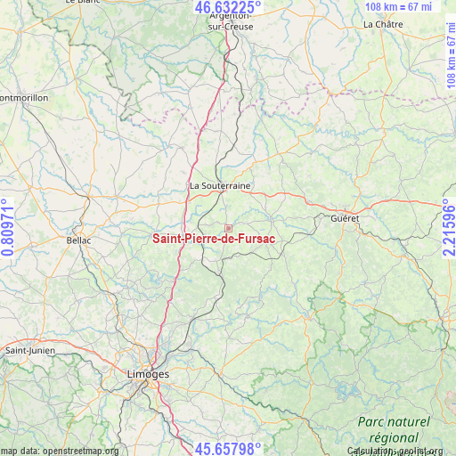
Saint-Pierre-de-Fursac GPS coordinates[2]
46° 8' 50.172" North, 1° 30' 46.188" East
| Map corner | latitude | longitude |
|---|---|---|
| Upper-left | 46.63225°, | 0.80971° |
| Center: | 46.14727°, | 1.51283° |
| Lower-right: | 45.65798°, | 2.21596° |
| Map W x H: | 108.3×108.3 km | = 67.3×67.3mi |
| max Lat: | 51.07786° ⇑64.3% North |
| Saint-Pierre-de-Fursac: | 46.14727° |
| min Lat: | ⇓35.7% South 41.3874° |
| min Long | Saint-Pierre-de | max Long |
| -5.08615° | 1.51283° | 9.52242° |
| W 37.1%⇐ | ⇒62.9% E |
Elevation
Elevation of Saint-Pierre-de-Fursac is 331 m = 1086 ft, and this is 137.3 m = 450 ft above average elevation for this country.
| Max E: |
2333 m = 7654 ft | 16.3% |
| Saint-Pierre-de-Fursac | 331 m 1086 ft | |
| Avg. | 193.7 m = 635 ft | |
Min E: |
-1 m = -3 ft | 83.7% |
See also: France elevation on elevation.city.
Geographical zone
Saint-Pierre-de-Fursac is located in North temperate zone (between Tropic of Cancer and the Arctic Circle). Distance of this North polar circle is 2270.1 km =1410.6 mi to North.| Distance of | km | miles | from Saint-Pierre-de-Fursac |
|---|---|---|---|
| North Pole | 4876 | 3029.8 | to North |
| Arctic Circle | 2270.1 | 1410.6 | to North |
| Tropic Cancer | 2525.2 | 1569.1 | to South |
| Equator | 5131.1 | 3188.3 | to South |


Nearby cities:
15 places around Saint-Pierre-de-Fursac: (largest is in red/bold)
• Bersac-sur-Rivalier
9.9 km =6.2 mi,  222°
222°
• Bessines-sur-Gartempe
11.9 km =7.4 mi,  249°
249°
• Bénévent-l’Abbaye
9.4 km =5.8 mi,  110°
110°
• Folles
5.4 km =3.4 mi,  228°
228°
• Fromental
9 km =5.6 mi,  278°
278°
• La Souterraine
10.3 km =6.4 mi,  348°
348°
• Laurière
8.4 km =5.2 mi,  200°
200°
• Le Grand-Bourg
10.3 km =6.4 mi,  81°
81°
• Marsac
7.9 km =4.9 mi,  133°
133°
• Mourioux-Vieilleville
12.7 km =7.9 mi,  123°
123°
• Saint-Agnant-de-Versillat
14.6 km =9.1 mi,  359°
359°
• Saint-Maurice-la-Souterraine
9.8 km =6.1 mi,  319°
319°
• Saint-Priest-la-Feuille
6.2 km =3.9 mi,  16°
16°
• Saint-Sulpice-Laurière
11 km =6.8 mi, 197°
• Saint-Étienne-de-Fursac
0.3 km =0.2 mi,  168°
168°
Sources, notices
• [Note1] Compared only with cities in France existing in our database
• [Src1] Map data: © OpenStreetMap contributors (CC-BY-SA)
• [Src2] Other city data from geonames.org with taken over terms of usage.
• [Src3] Geographical zone / Annual Mean Temperature by Robert A. Rohde @ Wikipedia
