Laurière geodata
Laurière (Nouvelle-Aquitaine) is a populated place; located in France in Europe/Paris (GMT+2) time zone. With population of 605 people, there are 13241 cities with bigger population in this country. Compared to other cities in France, 65.4% of cities are located further ↑North; 63.3% of cities are located further →East and 89.3% of cities have lower elevation than Laurière. Note1
Administrative division(s):
- Level 1: Nouvelle-Aquitaine
- Level 2: Haute-Vienne
- Level 3: Arrondissement de Limoges
- Level 4: Laurière


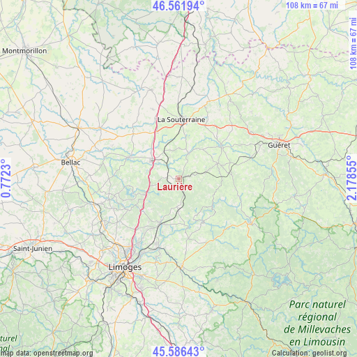
Laurière GPS coordinates[2]
46° 4' 34.824" North, 1° 28' 31.548" East
| Map corner | latitude | longitude |
|---|---|---|
| Upper-left | 46.56194°, | 0.7723° |
| Center: | 46.07634°, | 1.47543° |
| Lower-right: | 45.58643°, | 2.17855° |
| Map W x H: | 108.5×108.5 km | = 67.4×67.4mi |
| max Lat: | 51.07786° ⇑65.4% North |
| Laurière: | 46.07634° |
| min Lat: | ⇓34.6% South 41.3874° |
| min Long | Laurière | max Long |
| -5.08615° | 1.47543° | 9.52242° |
| W 36.7%⇐ | ⇒63.3% E |
Elevation
Elevation of Laurière is 411 m = 1348 ft, and this is 217.3 m = 713 ft above average elevation for this country.
| Max E: |
2333 m = 7654 ft | 10.7% |
| Laurière | 411 m 1348 ft | |
| Avg. | 193.7 m = 635 ft | |
Min E: |
-1 m = -3 ft | 89.3% |
See also: France elevation on elevation.city.
Geographical zone
Laurière is located in North temperate zone (between Tropic of Cancer and the Arctic Circle). Distance of this North polar circle is 2278 km =1415.5 mi to North.| Distance of | km | miles | from Laurière |
|---|---|---|---|
| North Pole | 4883.9 | 3034.7 | to North |
| Arctic Circle | 2278 | 1415.5 | to North |
| Tropic Cancer | 2517.3 | 1564.2 | to South |
| Equator | 5123.2 | 3183.4 | to South |


Nearby cities:
15 places around Laurière: (largest is in red/bold)
• Ambazac
14.5 km =9 mi,  203°
203°
• Bersac-sur-Rivalier
3.8 km =2.4 mi,  277°
277°
• Bessines-sur-Gartempe
9 km =5.6 mi,  293°
293°
• Bénévent-l’Abbaye
12.6 km =7.8 mi,  68°
68°
• Folles
4.5 km =2.8 mi,  344°
344°
• Fromental
11 km =6.8 mi,  326°
326°
• La Jonchère-Saint-Maurice
8.6 km =5.3 mi,  184°
184°
• Marsac
8.9 km =5.5 mi, 74°
• Mourioux-Vieilleville
13.5 km =8.4 mi,  86°
86°
• Razès
11.2 km =7 mi,  244°
244°
• Saint-Laurent-les-Églises
14.2 km =8.8 mi,  172°
172°
• Saint-Pierre-de-Fursac
8.4 km =5.2 mi,  20°
20°
• Saint-Sulpice-Laurière
2.6 km =1.6 mi,  188°
188°
• Saint-Sylvestre
11.8 km =7.3 mi,  220°
220°
• Saint-Étienne-de-Fursac
8.1 km =5 mi, 21°
Sources, notices
• [Note1] Compared only with cities in France existing in our database
• [Src1] Map data: © OpenStreetMap contributors (CC-BY-SA)
• [Src2] Other city data from geonames.org with taken over terms of usage.
• [Src3] Geographical zone / Annual Mean Temperature by Robert A. Rohde @ Wikipedia
