Bessines-sur-Gartempe geodata
Bessines-sur-Gartempe (Nouvelle-Aquitaine) is a populated place; located in France in Europe/Paris (GMT+2) time zone. With population of 2,836 people, there are 3438 cities with bigger population in this country. Compared to other cities in France, 64.9% of cities are located further ↑North; 64.8% of cities are located further →East and 81.6% of cities have lower elevation than Bessines-sur-Gartempe. Note1
Administrative division(s):
- Level 1: Nouvelle-Aquitaine
- Level 2: Haute-Vienne
- Level 3: Arrondissement de Bellac
- Level 4: Bessines-sur-Gartempe
Current local time in Bessines-sur-Gartempe:
08:40 AM, SaturdayDifference from your time zone: hours


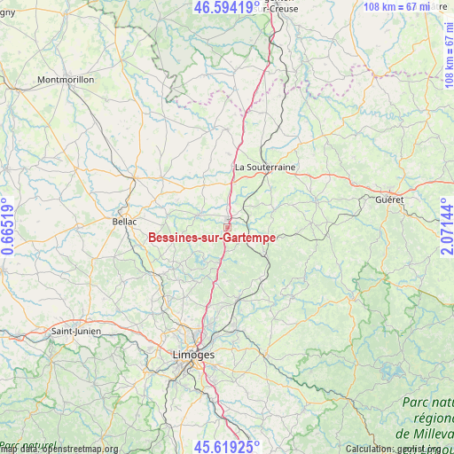
Bessines-sur-Gartempe GPS coordinates[2]
46° 6' 31.968" North, 1° 22' 5.916" East
| Map corner | latitude | longitude |
|---|---|---|
| Upper-left | 46.59419°, | 0.66519° |
| Center: | 46.10888°, | 1.36831° |
| Lower-right: | 45.61925°, | 2.07144° |
| Map W x H: | 108.4×108.4 km | = 67.4×67.4mi |
| max Lat: | 51.07786° ⇑64.9% North |
| Bessines-sur-Gartempe: | 46.10888° |
| min Lat: | ⇓35.1% South 41.3874° |
| min Long | Bessines-sur-Ga | max Long |
| -5.08615° | 1.36831° | 9.52242° |
| W 35.2%⇐ | ⇒64.8% E |
Elevation
Elevation of Bessines-sur-Gartempe is 306 m = 1004 ft, and this is 112.3 m = 368 ft above average elevation for this country.
| Max E: |
2333 m = 7654 ft | 18.4% |
| Bessines-sur-Gartempe | 306 m 1004 ft | |
| Avg. | 193.7 m = 635 ft | |
Min E: |
-1 m = -3 ft | 81.6% |
See also: France elevation on elevation.city.
Geographical zone
Bessines-sur-Gartempe is located in North temperate zone (between Tropic of Cancer and the Arctic Circle). Distance of this North polar circle is 2274.3 km =1413.2 mi to North.| Distance of | km | miles | from Bessines-sur-Gartempe |
|---|---|---|---|
| North Pole | 4880.2 | 3032.4 | to North |
| Arctic Circle | 2274.3 | 1413.2 | to North |
| Tropic Cancer | 2520.9 | 1566.4 | to South |
| Equator | 5126.8 | 3185.6 | to South |


Nearby cities:
15 places around Bessines-sur-Gartempe: (largest is in red/bold)
• Bersac-sur-Rivalier
5.5 km =3.4 mi,  124°
124°
• Châteauponsac
7.7 km =4.8 mi,  291°
291°
• Compreignac
14.9 km =9.3 mi,  209°
209°
• Folles
7.1 km =4.4 mi,  84°
84°
• Fromental
6 km =3.7 mi,  22°
22°
• La Jonchère-Saint-Maurice
14.4 km =8.9 mi,  147°
147°
• Laurière
9 km =5.6 mi,  113°
113°
• Rancon
14.5 km =9 mi,  279°
279°
• Razès
8.6 km =5.3 mi,  192°
192°
• Saint-Maurice-la-Souterraine
12.6 km =7.8 mi, 22°
• Saint-Pierre-de-Fursac
11.9 km =7.4 mi,  69°
69°
• Saint-Sornin-Leulac
11.4 km =7.1 mi,  331°
331°
• Saint-Sulpice-Laurière
10.1 km =6.3 mi,  128°
128°
• Saint-Sylvestre
12.6 km =7.8 mi,  177°
177°
• Saint-Étienne-de-Fursac
11.9 km =7.4 mi, 70°
Sources, notices
• [Note1] Compared only with cities in France existing in our database
• [Src1] Map data: © OpenStreetMap contributors (CC-BY-SA)
• [Src2] Other city data from geonames.org with taken over terms of usage.
• [Src3] Geographical zone / Annual Mean Temperature by Robert A. Rohde @ Wikipedia
