Saint-Pey-de-Castets geodata
Saint-Pey-de-Castets (Nouvelle-Aquitaine) is a populated place; located in France in Europe/Paris (GMT+2) time zone. With population of 664 people, there are 12308 cities with bigger population in this country. Compared to other cities in France, 81.3% of cities are located further ↑North; 78.6% of cities are located further →East and 68.7% of cities have higher elevation than Saint-Pey-de-Castets. Note1
Administrative division(s):
- Level 1: Nouvelle-Aquitaine
- Level 2: Gironde
- Level 3: Arrondissement de Libourne
- Level 4: Saint-Pey-de-Castets


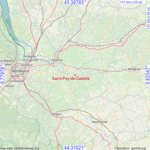
Saint-Pey-de-Castets GPS coordinates[2]
44° 48' 40.284" North, 0° 4' 3.576" West
| Map corner | latitude | longitude |
|---|---|---|
| Upper-left | 45.30785°, | -0.77078° |
| Center: | 44.81119°, | -0.06766° |
| Lower-right: | 44.31021°, | 0.63547° |
| Map W x H: | 110.9×110.9 km | = 68.9×68.9mi |
| max Lat: | 51.07786° ⇑81.3% North |
| Saint-Pey-de-Castets: | 44.81119° |
| min Lat: | ⇓18.7% South 41.3874° |
| min Long | Saint-Pey-de-Ca | max Long |
| -5.08615° | -0.06766° | 9.52242° |
| W 21.4%⇐ | ⇒78.6% E |
Elevation
Elevation of Saint-Pey-de-Castets is 81 m = 266 ft, and this is 112.7 m = 370 ft below average elevation for this country.
| Max E: |
2333 m = 7654 ft | 68.7% |
| Avg. | 193.7 m = 635 ft | |
| Saint-Pey-de-Castets | 81 m = 266 ft | |
Min E: |
-1 m = -3 ft | 31.3% |
See also: France elevation on elevation.city.
Geographical zone
Saint-Pey-de-Castets is located in North temperate zone (between Tropic of Cancer and the Arctic Circle). Distance of this Northern Tropic circle is 2376.6 km =1476.8 mi to South.| Distance of | km | miles | from Saint-Pey-de-Castets |
|---|---|---|---|
| North Pole | 5024.5 | 3122.1 | to North |
| Arctic Circle | 2418.6 | 1502.8 | to North |
| Tropic Cancer | 2376.6 | 1476.8 | to South |
| Equator | 4982.5 | 3096 | to South |


Nearby cities:
15 places around Saint-Pey-de-Castets: (largest is in red/bold)
• Blasimon
6.9 km =4.3 mi,  184°
184°
• Branne
9.4 km =5.8 mi,  285°
285°
• Castillon-la-Bataille
5.1 km =3.2 mi,  32°
32°
• Flaujagues
9.6 km =6 mi,  75°
75°
• Gensac
11.1 km =6.9 mi,  92°
92°
• Lamothe-Montravel
9.1 km =5.7 mi,  61°
61°
• Mouliets-et-Villemartin
4.7 km =2.9 mi, 58°
• Naujan-et-Postiac
9.2 km =5.7 mi,  254°
254°
• Rauzan
5.8 km =3.6 mi,  230°
230°
• Ruch
4.5 km =2.8 mi,  150°
150°
• Saint-Christophe-des-Bardes
8.4 km =5.2 mi,  342°
342°
• Saint-Sulpice-de-Faleyrens
11 km =6.8 mi,  304°
304°
• Saint-Émilion
10.3 km =6.4 mi,  321°
321°
• Sainte-Terre
4.6 km =2.9 mi, 302°
• Vignonet
8.9 km =5.5 mi, 298°
Sources, notices
• [Note1] Compared only with cities in France existing in our database
• [Src1] Map data: © OpenStreetMap contributors (CC-BY-SA)
• [Src2] Other city data from geonames.org with taken over terms of usage.
• [Src3] Geographical zone / Annual Mean Temperature by Robert A. Rohde @ Wikipedia
