Ruch geodata
Ruch (Nouvelle-Aquitaine) is a populated place; located in France in Europe/Paris (GMT+2) time zone. With population of 544 people, there are 14318 cities with bigger population in this country. Compared to other cities in France, 81.6% of cities are located further ↑North; 78.4% of cities are located further →East and 69.7% of cities have higher elevation than Ruch. Note1
Administrative division(s):
- Level 1: Nouvelle-Aquitaine
- Level 2: Gironde
- Level 3: Arrondissement de Langon
- Level 4: Ruch


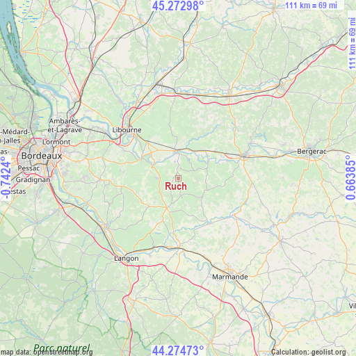
Ruch GPS coordinates[2]
44° 46' 33.636" North, 0° 2' 21.408" West
| Map corner | latitude | longitude |
|---|---|---|
| Upper-left | 45.27298°, | -0.7424° |
| Center: | 44.77601°, | -0.03928° |
| Lower-right: | 44.27473°, | 0.66385° |
| Map W x H: | 111×111 km | = 69×69mi |
| max Lat: | 51.07786° ⇑81.6% North |
| Ruch: | 44.77601° |
| min Lat: | ⇓18.4% South 41.3874° |
| min Long | Ruch | max Long |
| -5.08615° | -0.03928° | 9.52242° |
| W 21.6%⇐ | ⇒78.4% E |
Elevation
Elevation of Ruch is 79 m = 259 ft, and this is 114.7 m = 376 ft below average elevation for this country.
| Max E: |
2333 m = 7654 ft | 69.7% |
| Avg. | 193.7 m = 635 ft | |
| Ruch | 79 m = 259 ft | |
Min E: |
-1 m = -3 ft | 30.3% |
See also: France elevation on elevation.city.
Geographical zone
Ruch is located in North temperate zone (between Tropic of Cancer and the Arctic Circle). Distance of this Northern Tropic circle is 2372.7 km =1474.3 mi to South.| Distance of | km | miles | from Ruch |
|---|---|---|---|
| North Pole | 5028.4 | 3124.5 | to North |
| Arctic Circle | 2422.5 | 1505.3 | to North |
| Tropic Cancer | 2372.7 | 1474.3 | to South |
| Equator | 4978.6 | 3093.6 | to South |


Nearby cities:
15 places around Ruch: (largest is in red/bold)
• Blasimon
4.1 km =2.5 mi,  222°
222°
• Castillon-la-Bataille
8.2 km =5.1 mi,  3°
3°
• Flaujagues
9.5 km =5.9 mi,  47°
47°
• Frontenac
10.6 km =6.6 mi,  246°
246°
• Gensac
9.5 km =5.9 mi,  69°
69°
• Lamothe-Montravel
10 km =6.2 mi,  34°
34°
• Montcaret
11.7 km =7.3 mi, 45°
• Mouliets-et-Villemartin
6.6 km =4.1 mi,  15°
15°
• Naujan-et-Postiac
11.2 km =7 mi,  277°
277°
• Pellegrue
9.8 km =6.1 mi,  111°
111°
• Rauzan
6.7 km =4.2 mi,  272°
272°
• Saint-Pey-de-Castets
4.5 km =2.8 mi,  330°
330°
• Saint-Seurin-de-Prats
11.6 km =7.2 mi,  56°
56°
• Sainte-Terre
8.8 km =5.5 mi,  316°
316°
• Sauveterre-de-Guyenne
9.9 km =6.2 mi,  201°
201°
Sources, notices
• [Note1] Compared only with cities in France existing in our database
• [Src1] Map data: © OpenStreetMap contributors (CC-BY-SA)
• [Src2] Other city data from geonames.org with taken over terms of usage.
• [Src3] Geographical zone / Annual Mean Temperature by Robert A. Rohde @ Wikipedia
