Rauzan geodata
Rauzan (Nouvelle-Aquitaine) is a populated place; located in France in Europe/Paris (GMT+2) time zone. With population of 1,131 people, there are 7936 cities with bigger population in this country. Compared to other cities in France, 81.6% of cities are located further ↑North; 79% of cities are located further →East and 73.6% of cities have higher elevation than Rauzan. Note1
Administrative division(s):
- Level 1: Nouvelle-Aquitaine
- Level 2: Gironde
- Level 3: Arrondissement de Libourne
- Level 4: Rauzan


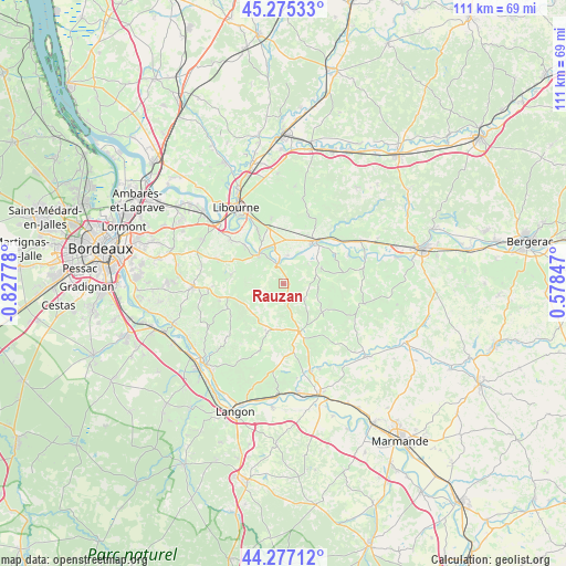
Rauzan GPS coordinates[2]
44° 46' 42.168" North, 0° 7' 28.74" West
| Map corner | latitude | longitude |
|---|---|---|
| Upper-left | 45.27533°, | -0.82778° |
| Center: | 44.77838°, | -0.12465° |
| Lower-right: | 44.27712°, | 0.57847° |
| Map W x H: | 111×111 km | = 69×69mi |
| max Lat: | 51.07786° ⇑81.6% North |
| Rauzan: | 44.77838° |
| min Lat: | ⇓18.4% South 41.3874° |
| min Long | Rauzan | max Long |
| -5.08615° | -0.12465° | 9.52242° |
| W 21%⇐ | ⇒79% E |
Elevation
Elevation of Rauzan is 70 m = 230 ft, and this is 123.7 m = 406 ft below average elevation for this country.
| Max E: |
2333 m = 7654 ft | 73.6% |
| Avg. | 193.7 m = 635 ft | |
| Rauzan | 70 m = 230 ft | |
Min E: |
-1 m = -3 ft | 26.4% |
See also: France elevation on elevation.city.
Geographical zone
Rauzan is located in North temperate zone (between Tropic of Cancer and the Arctic Circle). Distance of this Northern Tropic circle is 2373 km =1474.5 mi to South.| Distance of | km | miles | from Rauzan |
|---|---|---|---|
| North Pole | 5028.2 | 3124.4 | to North |
| Arctic Circle | 2422.3 | 1505.1 | to North |
| Tropic Cancer | 2373 | 1474.5 | to South |
| Equator | 4978.9 | 3093.7 | to South |


Nearby cities:
15 places around Rauzan: (largest is in red/bold)
• Blasimon
5.2 km =3.2 mi,  129°
129°
• Branne
7.7 km =4.8 mi,  322°
322°
• Castillon-la-Bataille
10.7 km =6.6 mi,  42°
42°
• Espiet
11.3 km =7 mi,  284°
284°
• Frontenac
5.4 km =3.4 mi,  213°
213°
• Grézillac
8.5 km =5.3 mi,  301°
301°
• Mouliets-et-Villemartin
10.5 km =6.5 mi,  54°
54°
• Moulon
10.8 km =6.7 mi, 317°
• Naujan-et-Postiac
4.6 km =2.9 mi,  285°
285°
• Ruch
6.7 km =4.2 mi,  92°
92°
• Saint-Pey-de-Castets
5.8 km =3.6 mi, 50°
• Saint-Sulpice-de-Faleyrens
10.9 km =6.8 mi,  334°
334°
• Sainte-Terre
6.1 km =3.8 mi,  5°
5°
• Sauveterre-de-Guyenne
10 km =6.2 mi,  161°
161°
• Vignonet
8.6 km =5.3 mi,  337°
337°
Sources, notices
• [Note1] Compared only with cities in France existing in our database
• [Src1] Map data: © OpenStreetMap contributors (CC-BY-SA)
• [Src2] Other city data from geonames.org with taken over terms of usage.
• [Src3] Geographical zone / Annual Mean Temperature by Robert A. Rohde @ Wikipedia
