Blasimon geodata
Blasimon (Nouvelle-Aquitaine) is a populated place; located in France in Europe/Paris (GMT+2) time zone. With population of 777 people, there are 10851 cities with bigger population in this country. Compared to other cities in France, 81.7% of cities are located further ↑North; 78.7% of cities are located further →East and 74.6% of cities have higher elevation than Blasimon. Note1
Administrative division(s):
- Level 1: Nouvelle-Aquitaine
- Level 2: Gironde
- Level 3: Arrondissement de Langon
- Level 4: Blasimon


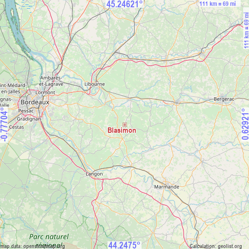
Blasimon GPS coordinates[2]
44° 44' 56.436" North, 0° 4' 26.112" West
| Map corner | latitude | longitude |
|---|---|---|
| Upper-left | 45.24621°, | -0.77704° |
| Center: | 44.74901°, | -0.07392° |
| Lower-right: | 44.2475°, | 0.62921° |
| Map W x H: | 111×111 km | = 69×69mi |
| max Lat: | 51.07786° ⇑81.7% North |
| Blasimon: | 44.74901° |
| min Lat: | ⇓18.3% South 41.3874° |
| min Long | Blasimon | max Long |
| -5.08615° | -0.07392° | 9.52242° |
| W 21.3%⇐ | ⇒78.7% E |
Elevation
Elevation of Blasimon is 68 m = 223 ft, and this is 125.7 m = 412 ft below average elevation for this country.
| Max E: |
2333 m = 7654 ft | 74.6% |
| Avg. | 193.7 m = 635 ft | |
| Blasimon | 68 m = 223 ft | |
Min E: |
-1 m = -3 ft | 25.4% |
See also: France elevation on elevation.city.
Geographical zone
Blasimon is located in North temperate zone (between Tropic of Cancer and the Arctic Circle). Distance of this Northern Tropic circle is 2369.7 km =1472.5 mi to South.| Distance of | km | miles | from Blasimon |
|---|---|---|---|
| North Pole | 5031.4 | 3126.4 | to North |
| Arctic Circle | 2425.6 | 1507.2 | to North |
| Tropic Cancer | 2369.7 | 1472.5 | to South |
| Equator | 4975.6 | 3091.7 | to South |


Nearby cities:
15 places around Blasimon: (largest is in red/bold)
• Branne
12.7 km =7.9 mi,  317°
317°
• Castillon-la-Bataille
11.7 km =7.3 mi,  15°
15°
• Flaujagues
13.5 km =8.4 mi,  46°
46°
• Frontenac
7.1 km =4.4 mi,  260°
260°
• Gensac
13.2 km =8.2 mi,  61°
61°
• Grézillac
13.6 km =8.5 mi,  304°
304°
• Mouliets-et-Villemartin
10.4 km =6.5 mi,  25°
25°
• Naujan-et-Postiac
9.5 km =5.9 mi, 297°
• Pellegrue
11.9 km =7.4 mi,  92°
92°
• Rauzan
5.2 km =3.2 mi,  309°
309°
• Ruch
4.1 km =2.5 mi,  42°
42°
• Saint-Pey-de-Castets
6.9 km =4.3 mi,  4°
4°
• Sainte-Terre
10 km =6.2 mi,  340°
340°
• Sauveterre-de-Guyenne
6.3 km =3.9 mi,  188°
188°
• Vignonet
13.4 km =8.3 mi,  326°
326°
Sources, notices
• [Note1] Compared only with cities in France existing in our database
• [Src1] Map data: © OpenStreetMap contributors (CC-BY-SA)
• [Src2] Other city data from geonames.org with taken over terms of usage.
• [Src3] Geographical zone / Annual Mean Temperature by Robert A. Rohde @ Wikipedia
