Saint-Paul-les-Fonts geodata
Saint-Paul-les-Fonts (Occitanie) is a populated place; located in France in Europe/Paris (GMT+2) time zone. With population of 669 people, there are 12229 cities with bigger population in this country. Compared to other cities in France, 86.4% of cities are located further ↑North; 72.9% of cities are located further ←West and 71% of cities have higher elevation than Saint-Paul-les-Fonts. Note1
Administrative division(s):
- Level 1: Occitanie
- Level 2: Gard
- Level 3: Arrondissement de Nîmes
- Level 4: Saint-Paul-les-Fonts


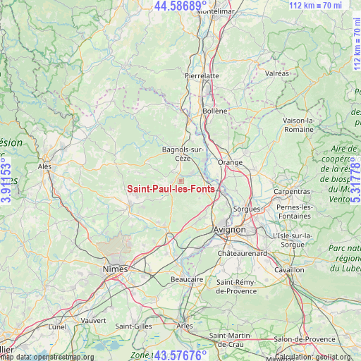
Saint-Paul-les-Fonts GPS coordinates[2]
44° 5' 2.328" North, 4° 36' 52.776" East
| Map corner | latitude | longitude |
|---|---|---|
| Upper-left | 44.58689°, | 3.91153° |
| Center: | 44.08398°, | 4.61466° |
| Lower-right: | 43.57676°, | 5.31778° |
| Map W x H: | 112.3×112.3 km | = 69.8×69.8mi |
| max Lat: | 51.07786° ⇑86.4% North |
| Saint-Paul-les-Fonts: | 44.08398° |
| min Lat: | ⇓13.6% South 41.3874° |
| min Long | Saint-Paul-les- | max Long |
| -5.08615° | 4.61466° | 9.52242° |
| W 72.9%⇐ | ⇒27.1% E |
Elevation
Elevation of Saint-Paul-les-Fonts is 76 m = 249 ft, and this is 117.7 m = 386 ft below average elevation for this country.
| Max E: |
2333 m = 7654 ft | 71% |
| Avg. | 193.7 m = 635 ft | |
| Saint-Paul-les-Fonts | 76 m = 249 ft | |
Min E: |
-1 m = -3 ft | 29% |
See also: France elevation on elevation.city.
Geographical zone
Saint-Paul-les-Fonts is located in North temperate zone (between Tropic of Cancer and the Arctic Circle). Distance of this Northern Tropic circle is 2295.8 km =1426.5 mi to South.| Distance of | km | miles | from Saint-Paul-les-Fonts |
|---|---|---|---|
| North Pole | 5105.4 | 3172.3 | to North |
| Arctic Circle | 2499.5 | 1553.1 | to North |
| Tropic Cancer | 2295.8 | 1426.5 | to South |
| Equator | 4901.7 | 3045.8 | to South |


Nearby cities:
15 places around Saint-Paul-les-Fonts: (largest is in red/bold)
• Bagnols-sur-Cèze
8.4 km =5.2 mi,  1°
1°
• Cavillargues
8.2 km =5.1 mi,  294°
294°
• Chusclan
8.9 km =5.5 mi,  36°
36°
• Codolet
8 km =5 mi,  56°
56°
• Connaux
1.8 km =1.1 mi, 289°
• Gaujac
3 km =1.9 mi,  263°
263°
• Laudun-l'Ardoise
4.5 km =2.8 mi,  66°
66°
• Lirac
7.9 km =4.9 mi,  132°
132°
• Orsan
6.6 km =4.1 mi, 37°
• Sabran
9.1 km =5.7 mi,  324°
324°
• Saint-Geniès-de-Comolas
8.8 km =5.5 mi,  103°
103°
• Saint-Laurent-des-Arbres
7.6 km =4.7 mi,  115°
115°
• Saint-Victor-la-Coste
3.2 km =2 mi,  136°
136°
• Tavel
10.4 km =6.5 mi, 139°
• Tresques
3.4 km =2.1 mi, 319°
Sources, notices
• [Note1] Compared only with cities in France existing in our database
• [Src1] Map data: © OpenStreetMap contributors (CC-BY-SA)
• [Src2] Other city data from geonames.org with taken over terms of usage.
• [Src3] Geographical zone / Annual Mean Temperature by Robert A. Rohde @ Wikipedia
