Bagnols-sur-Cèze geodata
Bagnols-sur-Cèze (Occitanie) is a populated place; located in France in Europe/Paris (GMT+2) time zone. With population of 19,640 people, there are 471 cities with bigger population in this country. Compared to other cities in France, 85.9% of cities are located further ↑North; 72.9% of cities are located further ←West and 71% of cities have higher elevation than Bagnols-sur-Cèze. Note1
Administrative division(s):
- Level 1: Occitanie
- Level 2: Gard
- Level 3: Arrondissement de Nîmes
- Level 4: Bagnols-sur-Cèze


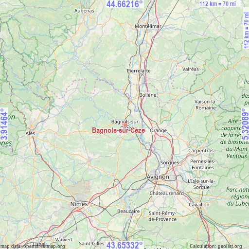
Bagnols-sur-Cèze GPS coordinates[2]
44° 9' 35.64" North, 4° 37' 3.936" East
| Map corner | latitude | longitude |
|---|---|---|
| Upper-left | 44.66216°, | 3.91464° |
| Center: | 44.1599°, | 4.61776° |
| Lower-right: | 43.65332°, | 5.32089° |
| Map W x H: | 112.2×112.2 km | = 69.7×69.7mi |
| max Lat: | 51.07786° ⇑85.9% North |
| Bagnols-sur-Cèze: | 44.1599° |
| min Lat: | ⇓14.1% South 41.3874° |
| min Long | Bagnols-sur-Cè | max Long |
| -5.08615° | 4.61776° | 9.52242° |
| W 72.9%⇐ | ⇒27.1% E |
Elevation
Elevation of Bagnols-sur-Cèze is 76 m = 249 ft, and this is 117.7 m = 386 ft below average elevation for this country.
| Max E: |
2333 m = 7654 ft | 71% |
| Avg. | 193.7 m = 635 ft | |
| Bagnols-sur-Cèze | 76 m = 249 ft | |
Min E: |
-1 m = -3 ft | 29% |
See also: France elevation on elevation.city.
Geographical zone
Bagnols-sur-Cèze is located in North temperate zone (between Tropic of Cancer and the Arctic Circle). Distance of this Northern Tropic circle is 2304.2 km =1431.8 mi to South.| Distance of | km | miles | from Bagnols-sur-Cèze |
|---|---|---|---|
| North Pole | 5096.9 | 3167.1 | to North |
| Arctic Circle | 2491.1 | 1547.9 | to North |
| Tropic Cancer | 2304.2 | 1431.8 | to South |
| Equator | 4910.1 | 3051 | to South |


Nearby cities:
15 places around Bagnols-sur-Cèze: (largest is in red/bold)
• Carsan
8.4 km =5.2 mi,  348°
348°
• Cavillargues
9.2 km =5.7 mi,  236°
236°
• Chusclan
5.2 km =3.2 mi,  104°
104°
• Codolet
7.6 km =4.7 mi,  122°
122°
• Connaux
8.1 km =5 mi,  193°
193°
• Laudun-l'Ardoise
7.7 km =4.8 mi,  149°
149°
• Orsan
5 km =3.1 mi,  130°
130°
• Sabran
5.6 km =3.5 mi,  259°
259°
• Saint-Alexandre
7.5 km =4.7 mi,  1°
1°
• Saint-Gervais
4.3 km =2.7 mi,  308°
308°
• Saint-Nazaire
4.3 km =2.7 mi,  6°
6°
• Saint-Paul-les-Fonts
8.4 km =5.2 mi,  181°
181°
• Saint-Étienne-des-Sorts
7.6 km =4.7 mi,  67°
67°
• Tresques
6.4 km =4 mi,  202°
202°
• Vénéjan
5.1 km =3.2 mi,  34°
34°
Sources, notices
• [Note1] Compared only with cities in France existing in our database
• [Src1] Map data: © OpenStreetMap contributors (CC-BY-SA)
• [Src2] Other city data from geonames.org with taken over terms of usage.
• [Src3] Geographical zone / Annual Mean Temperature by Robert A. Rohde @ Wikipedia
