Saint-Geniès-de-Comolas geodata
Saint-Geniès-de-Comolas (Occitanie) is a populated place; located in France in Europe/Paris (GMT+2) time zone. With population of 1,833 people, there are 5173 cities with bigger population in this country. Compared to other cities in France, 86.5% of cities are located further ↑North; 74% of cities are located further ←West and 78.6% of cities have higher elevation than Saint-Geniès-de-Comolas. Note1
Administrative division(s):
- Level 1: Occitanie
- Level 2: Gard
- Level 3: Arrondissement de Nîmes
- Level 4: Saint-Geniès-de-Comolas
Current local time in Saint-Geniès-de-Comolas:
06:02 AM, WednesdayDifference from your time zone: hours


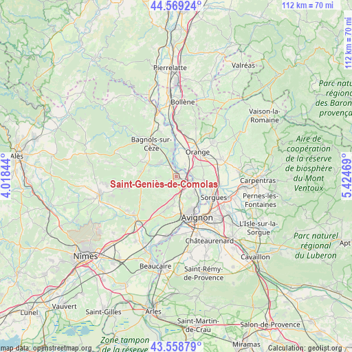
Saint-Geniès-de-Comolas GPS coordinates[2]
44° 3' 58.212" North, 4° 43' 17.652" East
| Map corner | latitude | longitude |
|---|---|---|
| Upper-left | 44.56924°, | 4.01844° |
| Center: | 44.06617°, | 4.72157° |
| Lower-right: | 43.55879°, | 5.42469° |
| Map W x H: | 112.4×112.3 km | = 69.8×69.8mi |
| max Lat: | 51.07786° ⇑86.5% North |
| Saint-Geniès-de-Comolas: | 44.06617° |
| min Lat: | ⇓13.5% South 41.3874° |
| min Long | Saint-Geniès-d | max Long |
| -5.08615° | 4.72157° | 9.52242° |
| W 74%⇐ | ⇒26% E |
Elevation
Elevation of Saint-Geniès-de-Comolas is 58 m = 190 ft, and this is 135.7 m = 445 ft below average elevation for this country.
| Max E: |
2333 m = 7654 ft | 78.6% |
| Avg. | 193.7 m = 635 ft | |
| Saint-Geniès-de-Comolas | 58 m = 190 ft | |
Min E: |
-1 m = -3 ft | 21.4% |
See also: France elevation on elevation.city.
Geographical zone
Saint-Geniès-de-Comolas is located in North temperate zone (between Tropic of Cancer and the Arctic Circle). Distance of this Northern Tropic circle is 2293.8 km =1425.3 mi to South.| Distance of | km | miles | from Saint-Geniès-de-Comolas |
|---|---|---|---|
| North Pole | 5107.4 | 3173.6 | to North |
| Arctic Circle | 2501.5 | 1554.4 | to North |
| Tropic Cancer | 2293.8 | 1425.3 | to South |
| Equator | 4899.7 | 3044.5 | to South |


Nearby cities:
15 places around Saint-Geniès-de-Comolas: (largest is in red/bold)
• Caderousse
5 km =3.1 mi,  34°
34°
• Chusclan
9.7 km =6 mi,  340°
340°
• Châteauneuf-du-Pape
8.9 km =5.5 mi,  97°
97°
• Codolet
6.7 km =4.2 mi, 343°
• Laudun-l'Ardoise
5.8 km =3.6 mi,  310°
310°
• Lirac
4.4 km =2.7 mi,  219°
219°
• Montfaucon
2.8 km =1.7 mi,  75°
75°
• Orsan
8.5 km =5.3 mi,  328°
328°
• Pujaut
8.2 km =5.1 mi,  147°
147°
• Roquemaure
4.8 km =3 mi,  112°
112°
• Saint-Laurent-des-Arbres
2.1 km =1.3 mi,  233°
233°
• Saint-Paul-les-Fonts
8.8 km =5.5 mi,  283°
283°
• Saint-Victor-la-Coste
6.3 km =3.9 mi,  266°
266°
• Sauveterre
7.5 km =4.7 mi,  129°
129°
• Tavel
6.2 km =3.9 mi,  197°
197°
Sources, notices
• [Note1] Compared only with cities in France existing in our database
• [Src1] Map data: © OpenStreetMap contributors (CC-BY-SA)
• [Src2] Other city data from geonames.org with taken over terms of usage.
• [Src3] Geographical zone / Annual Mean Temperature by Robert A. Rohde @ Wikipedia
