Laudun-l'Ardoise geodata
Laudun-l'Ardoise (Occitanie) is a populated place; located in France in Europe/Paris (GMT+2) time zone. With population of 5,610 people, there are 1766 cities with bigger population in this country. Compared to other cities in France, 86.2% of cities are located further ↑North; 73.4% of cities are located further ←West and 83.1% of cities have higher elevation than Laudun-l'Ardoise. Note1
Administrative division(s):
- Level 1: Occitanie
- Level 2: Gard
- Level 3: Arrondissement de Nîmes
- Level 4: Laudun-l'Ardoise


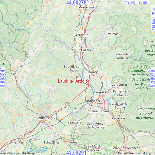
Laudun-l'Ardoise GPS coordinates[2]
44° 6' 0" North, 4° 40' 0.012" East
| Map corner | latitude | longitude |
|---|---|---|
| Upper-left | 44.60278°, | 3.96354° |
| Center: | 44.1°, | 4.66667° |
| Lower-right: | 43.59291°, | 5.36979° |
| Map W x H: | 112.3×112.3 km | = 69.8×69.8mi |
| max Lat: | 51.07786° ⇑86.2% North |
| Laudun-l'Ardoise: | 44.1° |
| min Lat: | ⇓13.8% South 41.3874° |
| min Long | Laudun-l'Ardois | max Long |
| -5.08615° | 4.66667° | 9.52242° |
| W 73.4%⇐ | ⇒26.6% E |
Elevation
Elevation of Laudun-l'Ardoise is 47 m = 154 ft, and this is 146.7 m = 481 ft below average elevation for this country.
| Max E: |
2333 m = 7654 ft | 83.1% |
| Avg. | 193.7 m = 635 ft | |
| Laudun-l'Ardoise | 47 m = 154 ft | |
Min E: |
-1 m = -3 ft | 16.9% |
See also: France elevation on elevation.city.
Geographical zone
Laudun-l'Ardoise is located in North temperate zone (between Tropic of Cancer and the Arctic Circle). Distance of this Northern Tropic circle is 2297.5 km =1427.6 mi to South.| Distance of | km | miles | from Laudun-l'Ardoise |
|---|---|---|---|
| North Pole | 5103.6 | 3171.2 | to North |
| Arctic Circle | 2497.7 | 1552 | to North |
| Tropic Cancer | 2297.5 | 1427.6 | to South |
| Equator | 4903.5 | 3046.9 | to South |


Nearby cities:
15 places around Laudun-l'Ardoise: (largest is in red/bold)
• Bagnols-sur-Cèze
7.7 km =4.8 mi,  329°
329°
• Caderousse
7.2 km =4.5 mi,  87°
87°
• Chusclan
5.5 km =3.4 mi,  12°
12°
• Codolet
3.6 km =2.2 mi,  43°
43°
• Connaux
5.9 km =3.7 mi,  258°
258°
• Gaujac
7.4 km =4.6 mi,  253°
253°
• Lirac
7.3 km =4.5 mi,  167°
167°
• Montfaucon
7.7 km =4.8 mi,  113°
113°
• Orsan
3.5 km =2.2 mi,  358°
358°
• Saint-Geniès-de-Comolas
5.8 km =3.6 mi,  130°
130°
• Saint-Laurent-des-Arbres
5.7 km =3.5 mi,  151°
151°
• Saint-Paul-les-Fonts
4.5 km =2.8 mi, 246°
• Saint-Victor-la-Coste
4.6 km =2.9 mi,  205°
205°
• Saint-Étienne-des-Sorts
10 km =6.2 mi,  18°
18°
• Tresques
6.4 km =4 mi,  276°
276°
Sources, notices
• [Note1] Compared only with cities in France existing in our database
• [Src1] Map data: © OpenStreetMap contributors (CC-BY-SA)
• [Src2] Other city data from geonames.org with taken over terms of usage.
• [Src3] Geographical zone / Annual Mean Temperature by Robert A. Rohde @ Wikipedia
