Sabran geodata
Sabran (Occitanie) is a populated place; located in France in Europe/Paris (GMT+2) time zone. With population of 1,841 people, there are 5145 cities with bigger population in this country. Compared to other cities in France, 85.9% of cities are located further ↑North; 72.4% of cities are located further ←West and 76.1% of cities have lower elevation than Sabran. Note1
Administrative division(s):
- Level 1: Occitanie
- Level 2: Gard
- Level 3: Arrondissement de Nîmes
- Level 4: Sabran


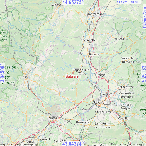
Sabran GPS coordinates[2]
44° 9' 1.44" North, 4° 32' 53.52" East
| Map corner | latitude | longitude |
|---|---|---|
| Upper-left | 44.65275°, | 3.84508° |
| Center: | 44.1504°, | 4.5482° |
| Lower-right: | 43.64374°, | 5.25133° |
| Map W x H: | 112.2×112.2 km | = 69.7×69.7mi |
| max Lat: | 51.07786° ⇑85.9% North |
| Sabran: | 44.1504° |
| min Lat: | ⇓14.1% South 41.3874° |
| min Long | Sabran | max Long |
| -5.08615° | 4.5482° | 9.52242° |
| W 72.4%⇐ | ⇒27.6% E |
Elevation
Elevation of Sabran is 257 m = 843 ft, and this is 63.3 m = 208 ft above average elevation for this country.
| Max E: |
2333 m = 7654 ft | 23.9% |
| Sabran | 257 m 843 ft | |
| Avg. | 193.7 m = 635 ft | |
Min E: |
-1 m = -3 ft | 76.1% |
See also: France elevation on elevation.city.
Geographical zone
Sabran is located in North temperate zone (between Tropic of Cancer and the Arctic Circle). Distance of this Northern Tropic circle is 2303.1 km =1431.1 mi to South.| Distance of | km | miles | from Sabran |
|---|---|---|---|
| North Pole | 5098 | 3167.7 | to North |
| Arctic Circle | 2492.1 | 1548.5 | to North |
| Tropic Cancer | 2303.1 | 1431.1 | to South |
| Equator | 4909.1 | 3050.4 | to South |


Nearby cities:
15 places around Sabran: (largest is in red/bold)
• Bagnols-sur-Cèze
5.6 km =3.5 mi,  79°
79°
• Carsan
10.1 km =6.3 mi,  22°
22°
• Cavillargues
4.5 km =2.8 mi,  208°
208°
• Connaux
7.7 km =4.8 mi,  151°
151°
• Cornillon
9.4 km =5.8 mi,  330°
330°
• Gaujac
8.1 km =5 mi,  162°
162°
• Goudargues
9.6 km =6 mi,  317°
317°
• Orsan
9.6 km =6 mi,  102°
102°
• Saint-Gervais
4.3 km =2.7 mi,  30°
30°
• Saint-Laurent-la-Vernède
8.6 km =5.3 mi,  235°
235°
• Saint-Marcel-de-Careiret
4.9 km =3 mi,  257°
257°
• Saint-Nazaire
8.1 km =5 mi,  48°
48°
• Saint-Paul-les-Fonts
9.1 km =5.7 mi,  144°
144°
• Tresques
5.8 km =3.6 mi, 147°
• Vénéjan
9.9 km =6.2 mi,  58°
58°
Sources, notices
• [Note1] Compared only with cities in France existing in our database
• [Src1] Map data: © OpenStreetMap contributors (CC-BY-SA)
• [Src2] Other city data from geonames.org with taken over terms of usage.
• [Src3] Geographical zone / Annual Mean Temperature by Robert A. Rohde @ Wikipedia
