Saint-Paul-Cap-de-Joux geodata
Saint-Paul-Cap-de-Joux (Occitanie) is a populated place; located in France in Europe/Paris (GMT+2) time zone. With population of 1,015 people, there are 8732 cities with bigger population in this country. Compared to other cities in France, 91.3% of cities are located further ↑North; 57.5% of cities are located further →East and 58.3% of cities have lower elevation than Saint-Paul-Cap-de-Joux. Note1
Administrative division(s):
- Level 1: Occitanie
- Level 2: Tarn
- Level 3: Arrondissement de Castres
- Level 4: Saint-Paul-Cap-de-Joux
Current local time in Saint-Paul-Cap-de-Joux:
09:00 AM, WednesdayDifference from your time zone: hours


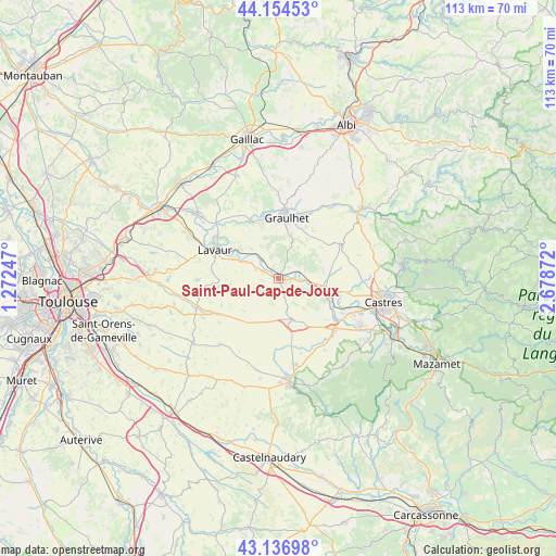
Saint-Paul-Cap-de-Joux GPS coordinates[2]
43° 38' 52.476" North, 1° 58' 32.124" East
| Map corner | latitude | longitude |
|---|---|---|
| Upper-left | 44.15453°, | 1.27247° |
| Center: | 43.64791°, | 1.97559° |
| Lower-right: | 43.13698°, | 2.67872° |
| Map W x H: | 113.1×113.1 km | = 70.3×70.3mi |
| max Lat: | 51.07786° ⇑91.3% North |
| Saint-Paul-Cap-de-Joux: | 43.64791° |
| min Lat: | ⇓8.7% South 41.3874° |
| min Long | Saint-Paul-Cap- | max Long |
| -5.08615° | 1.97559° | 9.52242° |
| W 42.5%⇐ | ⇒57.5% E |
Elevation
Elevation of Saint-Paul-Cap-de-Joux is 162 m = 531 ft, and this is 31.7 m = 104 ft below average elevation for this country.
| Max E: |
2333 m = 7654 ft | 41.7% |
| Avg. | 193.7 m = 635 ft | |
| Saint-Paul-Cap-de-Joux | 162 m = 531 ft | |
Min E: |
-1 m = -3 ft | 58.3% |
See also: France elevation on elevation.city.
Geographical zone
Saint-Paul-Cap-de-Joux is located in North temperate zone (between Tropic of Cancer and the Arctic Circle). Distance of this Northern Tropic circle is 2247.3 km =1396.4 mi to South.| Distance of | km | miles | from Saint-Paul-Cap-de-Joux |
|---|---|---|---|
| North Pole | 5153.9 | 3202.5 | to North |
| Arctic Circle | 2548 | 1583.3 | to North |
| Tropic Cancer | 2247.3 | 1396.4 | to South |
| Equator | 4853.2 | 3015.6 | to South |


Nearby cities:
15 places around Saint-Paul-Cap-de-Joux: (largest is in red/bold)
• Blan
13.8 km =8.6 mi,  168°
168°
• Briatexte
12.8 km =8 mi,  335°
335°
• Cuq-Toulza
13.2 km =8.2 mi,  214°
214°
• Damiatte
0.5 km =0.3 mi,  6°
6°
• Fiac
8.1 km =5 mi,  317°
317°
• Fréjeville
14 km =8.7 mi,  107°
107°
• Graulhet
13.3 km =8.3 mi,  4°
4°
• Labastide-Saint-Georges
11.9 km =7.4 mi,  298°
298°
• Lavaur
13.8 km =8.6 mi,  293°
293°
• Puylaurens
8.9 km =5.5 mi,  160°
160°
• Saint-Gauzens
12.6 km =7.8 mi,  331°
331°
• Saint-Germain-des-Prés
12 km =7.5 mi,  142°
142°
• Serviès
4.5 km =2.8 mi,  72°
72°
• Sémalens
12.6 km =7.8 mi,  119°
119°
• Vielmur-sur-Agout
10.6 km =6.6 mi, 109°
Sources, notices
• [Note1] Compared only with cities in France existing in our database
• [Src1] Map data: © OpenStreetMap contributors (CC-BY-SA)
• [Src2] Other city data from geonames.org with taken over terms of usage.
• [Src3] Geographical zone / Annual Mean Temperature by Robert A. Rohde @ Wikipedia
