Saint-Gauzens geodata
Saint-Gauzens (Occitanie) is a populated place; located in France in Europe/Paris (GMT+2) time zone. With population of 666 people, there are 12279 cities with bigger population in this country. Compared to other cities in France, 89.8% of cities are located further ↑North; 58.3% of cities are located further →East and 55.3% of cities have lower elevation than Saint-Gauzens. Note1
Administrative division(s):
- Level 1: Occitanie
- Level 2: Tarn
- Level 3: Arrondissement de Castres
- Level 4: Saint-Gauzens


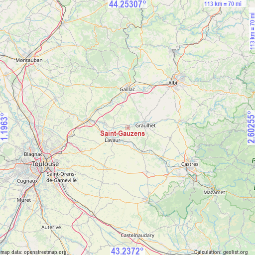
Saint-Gauzens GPS coordinates[2]
43° 44' 50.244" North, 1° 53' 57.948" East
| Map corner | latitude | longitude |
|---|---|---|
| Upper-left | 44.25307°, | 1.1963° |
| Center: | 43.74729°, | 1.89943° |
| Lower-right: | 43.2372°, | 2.60255° |
| Map W x H: | 113×113 km | = 70.2×70.2mi |
| max Lat: | 51.07786° ⇑89.8% North |
| Saint-Gauzens: | 43.74729° |
| min Lat: | ⇓10.2% South 41.3874° |
| min Long | Saint-Gauzens | max Long |
| -5.08615° | 1.89943° | 9.52242° |
| W 41.7%⇐ | ⇒58.3% E |
Elevation
Elevation of Saint-Gauzens is 151 m = 495 ft, and this is 42.7 m = 140 ft below average elevation for this country.
| Max E: |
2333 m = 7654 ft | 44.7% |
| Avg. | 193.7 m = 635 ft | |
| Saint-Gauzens | 151 m = 495 ft | |
Min E: |
-1 m = -3 ft | 55.3% |
See also: France elevation on elevation.city.
Geographical zone
Saint-Gauzens is located in North temperate zone (between Tropic of Cancer and the Arctic Circle). Distance of this Northern Tropic circle is 2258.3 km =1403.2 mi to South.| Distance of | km | miles | from Saint-Gauzens |
|---|---|---|---|
| North Pole | 5142.8 | 3195.6 | to North |
| Arctic Circle | 2536.9 | 1576.4 | to North |
| Tropic Cancer | 2258.3 | 1403.2 | to South |
| Equator | 4864.2 | 3022.5 | to South |


Nearby cities:
15 places around Saint-Gauzens: (largest is in red/bold)
• Ambres
7.2 km =4.5 mi,  256°
256°
• Briatexte
0.9 km =0.6 mi,  53°
53°
• Busque
6.2 km =3.9 mi, 51°
• Cadalen
13.1 km =8.1 mi,  29°
29°
• Damiatte
12.2 km =7.6 mi,  149°
149°
• Fiac
5.1 km =3.2 mi,  172°
172°
• Giroussens
10 km =6.2 mi,  279°
279°
• Graulhet
7.5 km =4.7 mi,  73°
73°
• Labastide-Saint-Georges
6.8 km =4.2 mi,  219°
219°
• Labessière-Candeil
10.5 km =6.5 mi, 54°
• Lavaur
8.5 km =5.3 mi,  230°
230°
• Parisot
8.2 km =5.1 mi,  315°
315°
• Saint-Lieux-lès-Lavaur
11.6 km =7.2 mi, 278°
• Saint-Paul-Cap-de-Joux
12.6 km =7.8 mi, 151°
• Técou
11.5 km =7.1 mi,  20°
20°
Sources, notices
• [Note1] Compared only with cities in France existing in our database
• [Src1] Map data: © OpenStreetMap contributors (CC-BY-SA)
• [Src2] Other city data from geonames.org with taken over terms of usage.
• [Src3] Geographical zone / Annual Mean Temperature by Robert A. Rohde @ Wikipedia
