Graulhet geodata
Graulhet (Occitanie) is a populated place; located in France in Europe/Paris (GMT+2) time zone. With population of 13,057 people, there are 731 cities with bigger population in this country. Compared to other cities in France, 89.5% of cities are located further ↑North; 57.3% of cities are located further →East and 57.4% of cities have lower elevation than Graulhet. Note1
Administrative division(s):
- Level 1: Occitanie
- Level 2: Tarn
- Level 3: Arrondissement de Castres
- Level 4: Graulhet


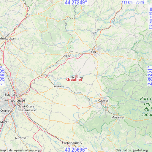
Graulhet GPS coordinates[2]
43° 46' 0.768" North, 1° 59' 21.768" East
| Map corner | latitude | longitude |
|---|---|---|
| Upper-left | 44.27249°, | 1.28626° |
| Center: | 43.76688°, | 1.98938° |
| Lower-right: | 43.25696°, | 2.69251° |
| Map W x H: | 112.9×112.9 km | = 70.2×70.2mi |
| max Lat: | 51.07786° ⇑89.5% North |
| Graulhet: | 43.76688° |
| min Lat: | ⇓10.5% South 41.3874° |
| min Long | Graulhet | max Long |
| -5.08615° | 1.98938° | 9.52242° |
| W 42.7%⇐ | ⇒57.3% E |
Elevation
Elevation of Graulhet is 159 m = 522 ft, and this is 34.7 m = 114 ft below average elevation for this country.
| Max E: |
2333 m = 7654 ft | 42.6% |
| Avg. | 193.7 m = 635 ft | |
| Graulhet | 159 m = 522 ft | |
Min E: |
-1 m = -3 ft | 57.4% |
See also: France elevation on elevation.city.
Geographical zone
Graulhet is located in North temperate zone (between Tropic of Cancer and the Arctic Circle). Distance of this Northern Tropic circle is 2260.5 km =1404.6 mi to South.| Distance of | km | miles | from Graulhet |
|---|---|---|---|
| North Pole | 5140.6 | 3194.2 | to North |
| Arctic Circle | 2534.8 | 1575.1 | to North |
| Tropic Cancer | 2260.5 | 1404.6 | to South |
| Equator | 4866.4 | 3023.8 | to South |


Nearby cities:
15 places around Graulhet: (largest is in red/bold)
• Briatexte
6.7 km =4.2 mi,  256°
256°
• Busque
2.9 km =1.8 mi,  305°
305°
• Cadalen
9.2 km =5.7 mi,  355°
355°
• Damiatte
12.8 km =8 mi,  184°
184°
• Fiac
9.8 km =6.1 mi,  222°
222°
• Florentin
13.9 km =8.6 mi,  14°
14°
• Labastide-Saint-Georges
13.7 km =8.5 mi,  237°
237°
• Labessière-Candeil
4.2 km =2.6 mi,  17°
17°
• Lautrec
13.8 km =8.6 mi,  119°
119°
• Lombers
13.4 km =8.3 mi,  74°
74°
• Parisot
13.4 km =8.3 mi,  285°
285°
• Saint-Gauzens
7.5 km =4.7 mi,  253°
253°
• Saint-Paul-Cap-de-Joux
13.3 km =8.3 mi, 184°
• Serviès
12.3 km =7.6 mi,  164°
164°
• Técou
9.1 km =5.7 mi,  339°
339°
Sources, notices
• [Note1] Compared only with cities in France existing in our database
• [Src1] Map data: © OpenStreetMap contributors (CC-BY-SA)
• [Src2] Other city data from geonames.org with taken over terms of usage.
• [Src3] Geographical zone / Annual Mean Temperature by Robert A. Rohde @ Wikipedia
