Saint-Paterne geodata
Saint-Paterne (Pays de la Loire) is a populated place; located in France in Europe/Paris (GMT+2) time zone. With population of 1,651 people, there are 5661 cities with bigger population in this country. Compared to other cities in France, 66.7% of cities are located further ↓South; 77.1% of cities are located further →East and 50.8% of cities have lower elevation than Saint-Paterne. Note1
Administrative division(s):
- Level 1: Pays de la Loire
- Level 2: Sarthe
- Level 3: Arrondissement de Mamers
- Level 4: Saint-Paterne - Le Chevain


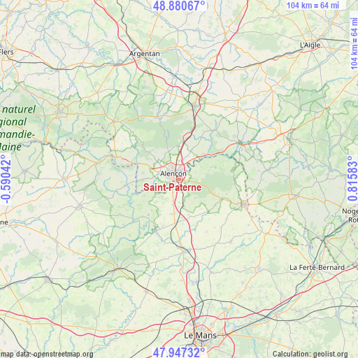
Saint-Paterne GPS coordinates[2]
48° 24' 58.104" North, 0° 6' 45.756" East
| Map corner | latitude | longitude |
|---|---|---|
| Upper-left | 48.88067°, | -0.59042° |
| Center: | 48.41614°, | 0.11271° |
| Lower-right: | 47.94732°, | 0.81583° |
| Map W x H: | 103.8×103.8 km | = 64.5×64.5mi |
| max Lat: | 51.07786° ⇑33.3% North |
| Saint-Paterne: | 48.41614° |
| min Lat: | ⇓66.7% South 41.3874° |
| min Long | Saint-Paterne | max Long |
| -5.08615° | 0.11271° | 9.52242° |
| W 22.9%⇐ | ⇒77.1% E |
Elevation
Elevation of Saint-Paterne is 135 m = 443 ft, and this is 58.7 m = 193 ft below average elevation for this country.
| Max E: |
2333 m = 7654 ft | 49.2% |
| Avg. | 193.7 m = 635 ft | |
| Saint-Paterne | 135 m = 443 ft | |
Min E: |
-1 m = -3 ft | 50.8% |
See also: France elevation on elevation.city.
Geographical zone
Saint-Paterne is located in North temperate zone (between Tropic of Cancer and the Arctic Circle). Distance of this North polar circle is 2017.8 km =1253.8 mi to North.| Distance of | km | miles | from Saint-Paterne |
|---|---|---|---|
| North Pole | 4623.7 | 2873 | to North |
| Arctic Circle | 2017.8 | 1253.8 | to North |
| Tropic Cancer | 2777.5 | 1725.9 | to South |
| Equator | 5383.4 | 3345.1 | to South |


Nearby cities:
15 places around Saint-Paterne: (largest is in red/bold)
• Alençon
2.5 km =1.6 mi,  325°
325°
• Ancinnes
7.2 km =4.5 mi,  139°
139°
• Arçonnay
2.9 km =1.8 mi,  222°
222°
• Cerisé
4.1 km =2.5 mi,  22°
22°
• Champfleur
3.5 km =2.2 mi,  159°
159°
• Condé-sur-Sarthe
6.1 km =3.8 mi,  286°
286°
• Damigny
5.1 km =3.2 mi,  317°
317°
• Héloup
6.7 km =4.2 mi,  252°
252°
• Le Chevain
2.1 km =1.3 mi,  35°
35°
• Lonrai
7.2 km =4.5 mi,  312°
312°
• Mieuxcé
7.6 km =4.7 mi,  256°
256°
• Oisseau-le-Petit
7.9 km =4.9 mi,  194°
194°
• Radon
9.6 km =6 mi,  355°
355°
• Saint-Germain-du-Corbéis
3.8 km =2.4 mi,  280°
280°
• Valframbert
5.4 km =3.4 mi, 356°
Sources, notices
• [Note1] Compared only with cities in France existing in our database
• [Src1] Map data: © OpenStreetMap contributors (CC-BY-SA)
• [Src2] Other city data from geonames.org with taken over terms of usage.
• [Src3] Geographical zone / Annual Mean Temperature by Robert A. Rohde @ Wikipedia
