Champfleur geodata
Champfleur (Pays de la Loire) is a populated place; located in France in Europe/Paris (GMT+2) time zone. With population of 1,193 people, there are 7578 cities with bigger population in this country. Compared to other cities in France, 66.1% of cities are located further ↓South; 76.9% of cities are located further →East and 54.2% of cities have lower elevation than Champfleur. Note1
Administrative division(s):
- Level 1: Pays de la Loire
- Level 2: Sarthe
- Level 3: Arrondissement de Mamers
- Level 4: Champfleur


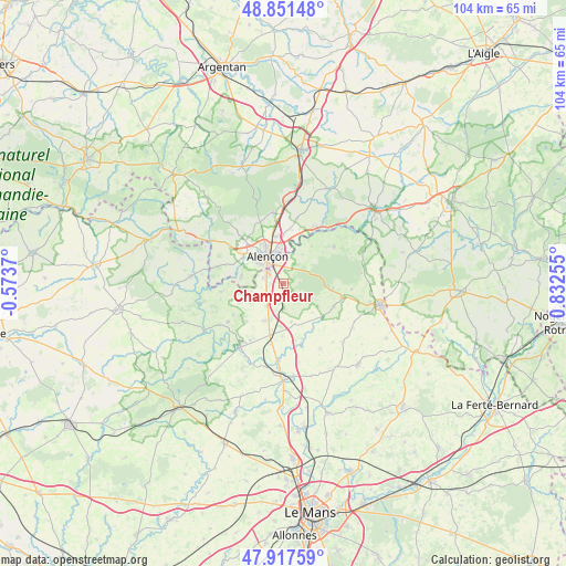
Champfleur GPS coordinates[2]
48° 23' 12.048" North, 0° 7' 45.912" East
| Map corner | latitude | longitude |
|---|---|---|
| Upper-left | 48.85148°, | -0.5737° |
| Center: | 48.38668°, | 0.12942° |
| Lower-right: | 47.91759°, | 0.83255° |
| Map W x H: | 103.8×103.8 km | = 64.5×64.5mi |
| max Lat: | 51.07786° ⇑33.9% North |
| Champfleur: | 48.38668° |
| min Lat: | ⇓66.1% South 41.3874° |
| min Long | Champfleur | max Long |
| -5.08615° | 0.12942° | 9.52242° |
| W 23.1%⇐ | ⇒76.9% E |
Elevation
Elevation of Champfleur is 147 m = 482 ft, and this is 46.7 m = 153 ft below average elevation for this country.
| Max E: |
2333 m = 7654 ft | 45.8% |
| Avg. | 193.7 m = 635 ft | |
| Champfleur | 147 m = 482 ft | |
Min E: |
-1 m = -3 ft | 54.2% |
See also: France elevation on elevation.city.
Geographical zone
Champfleur is located in North temperate zone (between Tropic of Cancer and the Arctic Circle). Distance of this North polar circle is 2021.1 km =1255.9 mi to North.| Distance of | km | miles | from Champfleur |
|---|---|---|---|
| North Pole | 4627 | 2875.1 | to North |
| Arctic Circle | 2021.1 | 1255.9 | to North |
| Tropic Cancer | 2774.2 | 1723.8 | to South |
| Equator | 5380.1 | 3343 | to South |


Nearby cities:
15 places around Champfleur: (largest is in red/bold)
• Alençon
6 km =3.7 mi,  333°
333°
• Ancinnes
4.1 km =2.5 mi,  121°
121°
• Arçonnay
3.4 km =2.1 mi,  289°
289°
• Cerisé
7 km =4.3 mi,  2°
2°
• Condé-sur-Sarthe
8.7 km =5.4 mi,  305°
305°
• Damigny
8.4 km =5.2 mi, 326°
• Fyé
7.7 km =4.8 mi,  208°
208°
• Héloup
7.7 km =4.8 mi,  279°
279°
• Le Chevain
5 km =3.1 mi,  359°
359°
• Mieuxcé
8.8 km =5.5 mi, 279°
• Neufchâtel-en-Saosnois
8.7 km =5.4 mi,  97°
97°
• Oisseau-le-Petit
5.4 km =3.4 mi,  216°
216°
• Saint-Germain-du-Corbéis
6.4 km =4 mi, 308°
• Saint-Paterne
3.5 km =2.2 mi,  339°
339°
• Valframbert
8.8 km =5.5 mi,  349°
349°
Sources, notices
• [Note1] Compared only with cities in France existing in our database
• [Src1] Map data: © OpenStreetMap contributors (CC-BY-SA)
• [Src2] Other city data from geonames.org with taken over terms of usage.
• [Src3] Geographical zone / Annual Mean Temperature by Robert A. Rohde @ Wikipedia
