Cerisé geodata
Cerisé (Normandy) is a populated place; located in France in Europe/Paris (GMT+2) time zone. With population of 808 people, there are 10506 cities with bigger population in this country. Compared to other cities in France, 67.2% of cities are located further ↓South; 76.9% of cities are located further →East and 53.1% of cities have lower elevation than Cerisé. Note1
Administrative division(s):
- Level 1: Normandy
- Level 2: Département de l'Orne
- Level 3: Arrondissement d’Alençon
- Level 4: Cerisé


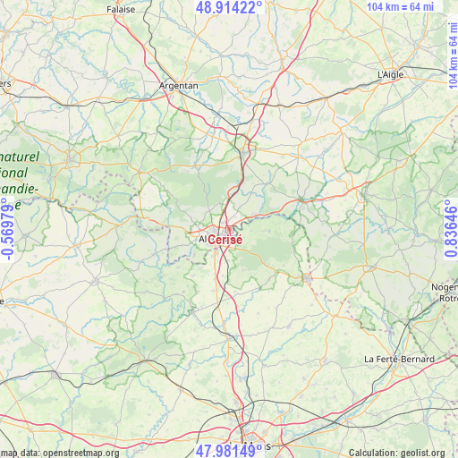
Cerisé GPS coordinates[2]
48° 27' 0" North, 0° 7' 59.988" East
| Map corner | latitude | longitude |
|---|---|---|
| Upper-left | 48.91422°, | -0.56979° |
| Center: | 48.45°, | 0.13333° |
| Lower-right: | 47.98149°, | 0.83646° |
| Map W x H: | 103.7×103.7 km | = 64.4×64.4mi |
| max Lat: | 51.07786° ⇑32.8% North |
| Cerisé: | 48.45° |
| min Lat: | ⇓67.2% South 41.3874° |
| min Long | Cerisé | max Long |
| -5.08615° | 0.13333° | 9.52242° |
| W 23.1%⇐ | ⇒76.9% E |
Elevation
Elevation of Cerisé is 143 m = 469 ft, and this is 50.7 m = 166 ft below average elevation for this country.
| Max E: |
2333 m = 7654 ft | 46.9% |
| Avg. | 193.7 m = 635 ft | |
| Cerisé | 143 m = 469 ft | |
Min E: |
-1 m = -3 ft | 53.1% |
See also: France elevation on elevation.city.
Geographical zone
Cerisé is located in North temperate zone (between Tropic of Cancer and the Arctic Circle). Distance of this North polar circle is 2014 km =1251.4 mi to North.| Distance of | km | miles | from Cerisé |
|---|---|---|---|
| North Pole | 4619.9 | 2870.7 | to North |
| Arctic Circle | 2014 | 1251.4 | to North |
| Tropic Cancer | 2781.2 | 1728.2 | to South |
| Equator | 5387.1 | 3347.4 | to South |


Nearby cities:
15 places around Cerisé: (largest is in red/bold)
• Alençon
3.4 km =2.1 mi,  240°
240°
• Ancinnes
9.8 km =6.1 mi,  160°
160°
• Arçonnay
6.9 km =4.3 mi,  210°
210°
• Champfleur
7 km =4.3 mi,  182°
182°
• Condé-sur-Sarthe
7.6 km =4.7 mi,  254°
254°
• Damigny
4.9 km =3 mi,  270°
270°
• Héloup
9.8 km =6.1 mi,  233°
233°
• La Fresnaye-sur-Chédouet
8.9 km =5.5 mi,  91°
91°
• Le Chevain
2.1 km =1.3 mi,  188°
188°
• Lonrai
7 km =4.3 mi,  279°
279°
• Mieuxcé
10.5 km =6.5 mi, 238°
• Radon
6.3 km =3.9 mi,  338°
338°
• Saint-Germain-du-Corbéis
6.1 km =3.8 mi, 239°
• Saint-Paterne
4.1 km =2.5 mi,  202°
202°
• Valframbert
2.5 km =1.6 mi,  311°
311°
Sources, notices
• [Note1] Compared only with cities in France existing in our database
• [Src1] Map data: © OpenStreetMap contributors (CC-BY-SA)
• [Src2] Other city data from geonames.org with taken over terms of usage.
• [Src3] Geographical zone / Annual Mean Temperature by Robert A. Rohde @ Wikipedia
