Saint-Ours geodata
Saint-Ours (Auvergne-Rhône-Alpes) is a populated place; located in France in Europe/Paris (GMT+2) time zone. With population of 1,425 people, there are 6507 cities with bigger population in this country. Compared to other cities in France, 68.5% of cities are located further ↑North; 56.3% of cities are located further ←West and 97.9% of cities have lower elevation than Saint-Ours. Note1
Administrative division(s):
- Level 1: Auvergne-Rhône-Alpes
- Level 2: Département du Puy-de-Dôme
- Level 3: Arrondissement de Riom
- Level 4: Saint-Ours


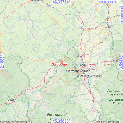
Saint-Ours GPS coordinates[2]
45° 51' 0.864" North, 2° 53' 29.868" East
| Map corner | latitude | longitude |
|---|---|---|
| Upper-left | 46.33784°, | 2.1885° |
| Center: | 45.85024°, | 2.89163° |
| Lower-right: | 45.35833°, | 3.59475° |
| Map W x H: | 108.9×108.9 km | = 67.7×67.7mi |
| max Lat: | 51.07786° ⇑68.5% North |
| Saint-Ours: | 45.85024° |
| min Lat: | ⇓31.5% South 41.3874° |
| min Long | Saint-Ours | max Long |
| -5.08615° | 2.89163° | 9.52242° |
| W 56.3%⇐ | ⇒43.7% E |
Elevation
Elevation of Saint-Ours is 812 m = 2664 ft, and this is 618.3 m = 2029 ft above average elevation for this country.
| Max E: |
2333 m = 7654 ft | 2.1% |
| Saint-Ours | 812 m 2664 ft | |
| Avg. | 193.7 m = 635 ft | |
Min E: |
-1 m = -3 ft | 97.9% |
See also: France elevation on elevation.city.
Geographical zone
Saint-Ours is located in North temperate zone (between Tropic of Cancer and the Arctic Circle). Distance of this North polar circle is 2303.1 km =1431.1 mi to North.| Distance of | km | miles | from Saint-Ours |
|---|---|---|---|
| North Pole | 4909 | 3050.3 | to North |
| Arctic Circle | 2303.1 | 1431.1 | to North |
| Tropic Cancer | 2492.1 | 1548.5 | to South |
| Equator | 5098.1 | 3167.8 | to South |


Nearby cities:
15 places around Saint-Ours: (largest is in red/bold)
• Chanat-la-Mouteyre
9.8 km =6.1 mi,  102°
102°
• Chapdes-Beaufort
5.2 km =3.2 mi,  335°
335°
• Charbonnières-les-Varennes
10.5 km =6.5 mi,  52°
52°
• La Goutelle
10.3 km =6.4 mi,  264°
264°
• Les Ancizes
10.3 km =6.4 mi,  323°
323°
• Loubeyrat
13.2 km =8.2 mi,  44°
44°
• Malauzat
12.5 km =7.8 mi,  91°
91°
• Manzat
13 km =8.1 mi,  17°
17°
• Mazaye
7.6 km =4.7 mi,  198°
198°
• Olby
11.8 km =7.3 mi,  189°
189°
• Orcines
12 km =7.5 mi,  128°
128°
• Pontgibaud
3.7 km =2.3 mi,  237°
237°
• Saint-Georges-de-Mons
10.7 km =6.6 mi, 337°
• Sayat
12.7 km =7.9 mi, 102°
• Volvic
11.6 km =7.2 mi,  77°
77°
Sources, notices
• [Note1] Compared only with cities in France existing in our database
• [Src1] Map data: © OpenStreetMap contributors (CC-BY-SA)
• [Src2] Other city data from geonames.org with taken over terms of usage.
• [Src3] Geographical zone / Annual Mean Temperature by Robert A. Rohde @ Wikipedia
