Charbonnières-les-Varennes geodata
Charbonnières-les-Varennes (Auvergne-Rhône-Alpes) is a populated place; located in France in Europe/Paris (GMT+2) time zone. With population of 1,341 people, there are 6861 cities with bigger population in this country. Compared to other cities in France, 67.5% of cities are located further ↑North; 57.8% of cities are located further ←West and 96.9% of cities have lower elevation than Charbonnières-les-Varennes. Note1
Administrative division(s):
- Level 1: Auvergne-Rhône-Alpes
- Level 2: Département du Puy-de-Dôme
- Level 3: Arrondissement de Riom
- Level 4: Charbonnières-les-Varennes
Current local time in Charbonnières-les-Varennes:
07:40 AM, SaturdayDifference from your time zone: hours


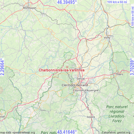
Charbonnières-les-Varennes GPS coordinates[2]
45° 54' 28.296" North, 2° 59' 59.136" East
| Map corner | latitude | longitude |
|---|---|---|
| Upper-left | 46.39495°, | 2.29664° |
| Center: | 45.90786°, | 2.99976° |
| Lower-right: | 45.41646°, | 3.70289° |
| Map W x H: | 108.8×108.8 km | = 67.6×67.6mi |
| max Lat: | 51.07786° ⇑67.5% North |
| Charbonnières-les-Varennes: | 45.90786° |
| min Lat: | ⇓32.5% South 41.3874° |
| min Long | Charbonnières- | max Long |
| -5.08615° | 2.99976° | 9.52242° |
| W 57.8%⇐ | ⇒42.2% E |
Elevation
Elevation of Charbonnières-les-Varennes is 719 m = 2359 ft, and this is 525.3 m = 1723 ft above average elevation for this country.
| Max E: |
2333 m = 7654 ft | 3.1% |
| Charbonnières-les-Varennes | 719 m 2359 ft | |
| Avg. | 193.7 m = 635 ft | |
Min E: |
-1 m = -3 ft | 96.9% |
See also: France elevation on elevation.city.
Geographical zone
Charbonnières-les-Varennes is located in North temperate zone (between Tropic of Cancer and the Arctic Circle). Distance of this North polar circle is 2296.7 km =1427.1 mi to North.| Distance of | km | miles | from Charbonnières-les-Varennes |
|---|---|---|---|
| North Pole | 4902.6 | 3046.3 | to North |
| Arctic Circle | 2296.7 | 1427.1 | to North |
| Tropic Cancer | 2498.6 | 1552.6 | to South |
| Equator | 5104.5 | 3171.8 | to South |


Nearby cities:
15 places around Charbonnières-les-Varennes: (largest is in red/bold)
• Chanat-la-Mouteyre
8.6 km =5.3 mi,  172°
172°
• Charbonnières-les-Vieilles
9.7 km =6 mi,  359°
359°
• Châteaugay
9.1 km =5.7 mi,  133°
133°
• Châtel-Guyon
5.2 km =3.2 mi,  71°
71°
• Davayat
9.5 km =5.9 mi,  62°
62°
• Enval
4 km =2.5 mi,  103°
103°
• Loubeyrat
3.2 km =2 mi,  14°
14°
• Malauzat
7.9 km =4.9 mi,  148°
148°
• Manzat
7.5 km =4.7 mi,  322°
322°
• Marsat
7.2 km =4.5 mi,  118°
118°
• Mozac
7.5 km =4.7 mi, 101°
• Riom
8.9 km =5.5 mi, 100°
• Saint-Bonnet-près-Riom
9.1 km =5.7 mi, 74°
• Sayat
9.9 km =6.2 mi,  155°
155°
• Volvic
5 km =3.1 mi,  143°
143°
In other languages:
- In France: Charbonnières-les-Varennes, Charbonnières-lès-Varennes
- In Chinese: 沙尔博尼埃莱瓦雷内
Sources, notices
• [Note1] Compared only with cities in France existing in our database
• [Src1] Map data: © OpenStreetMap contributors (CC-BY-SA)
• [Src2] Other city data from geonames.org with taken over terms of usage.
• [Src3] Geographical zone / Annual Mean Temperature by Robert A. Rohde @ Wikipedia
