Sayat geodata
Sayat (Auvergne-Rhône-Alpes) is a populated place; located in France in Europe/Paris (GMT+2) time zone. With population of 2,359 people, there are 4098 cities with bigger population in this country. Compared to other cities in France, 68.9% of cities are located further ↑North; 58.5% of cities are located further ←West and 91.1% of cities have lower elevation than Sayat. Note1
Administrative division(s):
- Level 1: Auvergne-Rhône-Alpes
- Level 2: Département du Puy-de-Dôme
- Level 3: Arrondissement de Riom
- Level 4: Sayat


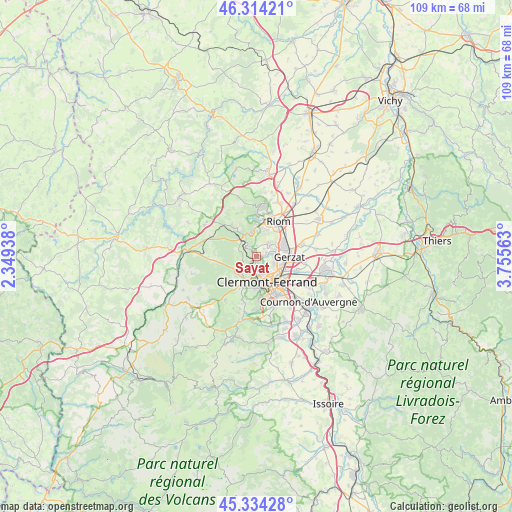
Sayat GPS coordinates[2]
45° 49' 35.04" North, 3° 3' 9" East
| Map corner | latitude | longitude |
|---|---|---|
| Upper-left | 46.31421°, | 2.34938° |
| Center: | 45.8264°, | 3.0525° |
| Lower-right: | 45.33428°, | 3.75563° |
| Map W x H: | 109×109 km | = 67.7×67.7mi |
| max Lat: | 51.07786° ⇑68.9% North |
| Sayat: | 45.8264° |
| min Lat: | ⇓31.1% South 41.3874° |
| min Long | Sayat | max Long |
| -5.08615° | 3.0525° | 9.52242° |
| W 58.5%⇐ | ⇒41.5% E |
Elevation
Elevation of Sayat is 451 m = 1480 ft, and this is 257.3 m = 844 ft above average elevation for this country.
| Max E: |
2333 m = 7654 ft | 8.9% |
| Sayat | 451 m 1480 ft | |
| Avg. | 193.7 m = 635 ft | |
Min E: |
-1 m = -3 ft | 91.1% |
See also: France elevation on elevation.city.
Geographical zone
Sayat is located in North temperate zone (between Tropic of Cancer and the Arctic Circle). Distance of this North polar circle is 2305.8 km =1432.8 mi to North.| Distance of | km | miles | from Sayat |
|---|---|---|---|
| North Pole | 4911.6 | 3051.9 | to North |
| Arctic Circle | 2305.8 | 1432.8 | to North |
| Tropic Cancer | 2489.5 | 1546.9 | to South |
| Equator | 5095.4 | 3166.1 | to South |


Nearby cities:
15 places around Sayat: (largest is in red/bold)
• Blanzat
2 km =1.2 mi,  79°
79°
• Chamalières
6 km =3.7 mi,  169°
169°
• Chanat-la-Mouteyre
2.9 km =1.8 mi,  279°
279°
• Châteaugay
3.7 km =2.3 mi,  42°
42°
• Clermont-Ferrand
5.8 km =3.6 mi,  152°
152°
• Cébazat
3.7 km =2.3 mi, 81°
• Durtol
3.4 km =2.1 mi,  181°
181°
• Gerzat
7.1 km =4.4 mi,  90°
90°
• Malauzat
2.3 km =1.4 mi,  0°
0°
• Marsat
6 km =3.7 mi,  22°
22°
• Ménétrol
7.5 km =4.7 mi,  47°
47°
• Nohanent
2 km =1.2 mi, 174°
• Orcines
5.8 km =3.6 mi,  212°
212°
• Royat
6.8 km =4.2 mi, 181°
• Volvic
5.2 km =3.2 mi,  347°
347°
Sources, notices
• [Note1] Compared only with cities in France existing in our database
• [Src1] Map data: © OpenStreetMap contributors (CC-BY-SA)
• [Src2] Other city data from geonames.org with taken over terms of usage.
• [Src3] Geographical zone / Annual Mean Temperature by Robert A. Rohde @ Wikipedia
