Saint-Nicolas-de-Redon geodata
Saint-Nicolas-de-Redon (Pays de la Loire) is a populated place; located in France in Europe/Paris (GMT+2) time zone. With population of 3,055 people, there are 3186 cities with bigger population in this country. Compared to other cities in France, 53.4% of cities are located further ↓South; 95.1% of cities are located further →East and 89.1% of cities have higher elevation than Saint-Nicolas-de-Redon. Note1
Administrative division(s):
- Level 1: Pays de la Loire
- Level 2: Loire-Atlantique
- Level 3: Arrondissement of Châteaubriant-Ancenis
- Level 4: Saint-Nicolas-de-Redon


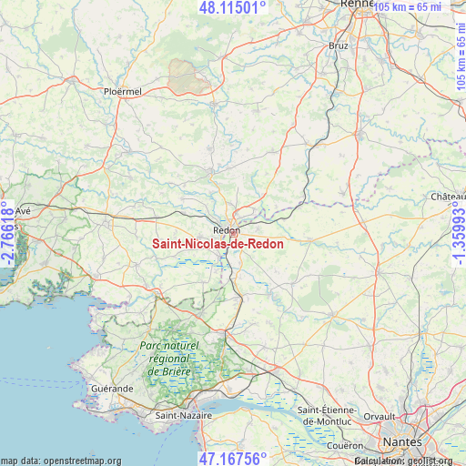
Saint-Nicolas-de-Redon GPS coordinates[2]
47° 38' 36.348" North, 2° 3' 46.98" West
| Map corner | latitude | longitude |
|---|---|---|
| Upper-left | 48.11501°, | -2.76618° |
| Center: | 47.64343°, | -2.06305° |
| Lower-right: | 47.16756°, | -1.35993° |
| Map W x H: | 105.3×105.3 km | = 65.4×65.4mi |
| max Lat: | 51.07786° ⇑46.6% North |
| Saint-Nicolas-de-Redon: | 47.64343° |
| min Lat: | ⇓53.4% South 41.3874° |
| min Long | Saint-Nicolas-d | max Long |
| -5.08615° | -2.06305° | 9.52242° |
| W 4.9%⇐ | ⇒95.1% E |
Elevation
Elevation of Saint-Nicolas-de-Redon is 32 m = 105 ft, and this is 161.7 m = 531 ft below average elevation for this country.
| Max E: |
2333 m = 7654 ft | 89.1% |
| Avg. | 193.7 m = 635 ft | |
| Saint-Nicolas-de-Redon | 32 m = 105 ft | |
Min E: |
-1 m = -3 ft | 10.9% |
See also: France elevation on elevation.city.
Geographical zone
Saint-Nicolas-de-Redon is located in North temperate zone (between Tropic of Cancer and the Arctic Circle). Distance of this North polar circle is 2103.7 km =1307.2 mi to North.| Distance of | km | miles | from Saint-Nicolas-de-Redon |
|---|---|---|---|
| North Pole | 4709.6 | 2926.4 | to North |
| Arctic Circle | 2103.7 | 1307.2 | to North |
| Tropic Cancer | 2691.5 | 1672.4 | to South |
| Equator | 5297.5 | 3291.7 | to South |


Nearby cities:
15 places around Saint-Nicolas-de-Redon: (largest is in red/bold)
• Allaire
7.5 km =4.7 mi,  264°
264°
• Avessac
5.6 km =3.5 mi,  78°
78°
• Bains-sur-Oust
6.7 km =4.2 mi,  355°
355°
• Cournon
11.8 km =7.3 mi,  343°
343°
• Fégréac
6.7 km =4.2 mi,  167°
167°
• Glénac
10.7 km =6.6 mi,  330°
330°
• Redon
1.9 km =1.2 mi,  298°
298°
• Renac
10.8 km =6.7 mi,  37°
37°
• Rieux
6.1 km =3.8 mi,  213°
213°
• Saint-Jean-la-Poterie
4.7 km =2.9 mi, 259°
• Saint-Perreux
4.4 km =2.7 mi,  310°
310°
• Saint-Vincent-sur-Oust
8.9 km =5.5 mi,  315°
315°
• Sainte-Marie
7.3 km =4.5 mi, 38°
• Sévérac
10.4 km =6.5 mi,  184°
184°
• Théhillac
9.4 km =5.8 mi, 205°
Sources, notices
• [Note1] Compared only with cities in France existing in our database
• [Src1] Map data: © OpenStreetMap contributors (CC-BY-SA)
• [Src2] Other city data from geonames.org with taken over terms of usage.
• [Src3] Geographical zone / Annual Mean Temperature by Robert A. Rohde @ Wikipedia
