Allaire geodata
Allaire (Brittany) is a populated place; located in France in Europe/Paris (GMT+2) time zone. With population of 3,427 people, there are 2836 cities with bigger population in this country. Compared to other cities in France, 53.3% of cities are located further ↓South; 95.4% of cities are located further →East and 75.4% of cities have higher elevation than Allaire. Note1
Administrative division(s):
- Level 1: Brittany
- Level 2: Morbihan
- Level 3: Arrondissement de Vannes
- Level 4: Allaire


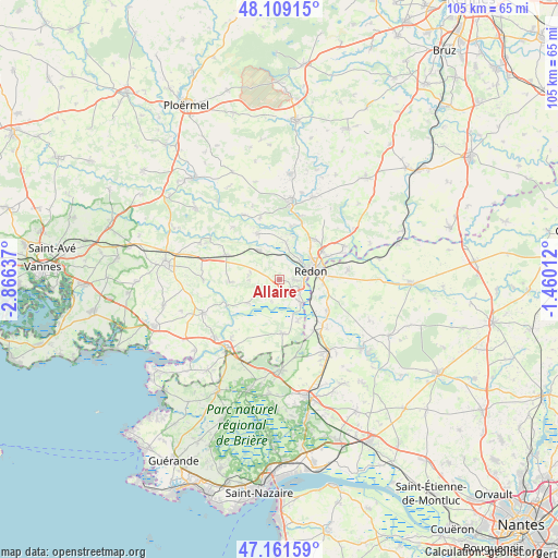
Allaire GPS coordinates[2]
47° 38' 15.072" North, 2° 9' 47.664" West
| Map corner | latitude | longitude |
|---|---|---|
| Upper-left | 48.10915°, | -2.86637° |
| Center: | 47.63752°, | -2.16324° |
| Lower-right: | 47.16159°, | -1.46012° |
| Map W x H: | 105.4×105.4 km | = 65.5×65.5mi |
| max Lat: | 51.07786° ⇑46.7% North |
| Allaire: | 47.63752° |
| min Lat: | ⇓53.3% South 41.3874° |
| min Long | Allaire | max Long |
| -5.08615° | -2.16324° | 9.52242° |
| W 4.6%⇐ | ⇒95.4% E |
Elevation
Elevation of Allaire is 66 m = 217 ft, and this is 127.7 m = 419 ft below average elevation for this country.
| Max E: |
2333 m = 7654 ft | 75.4% |
| Avg. | 193.7 m = 635 ft | |
| Allaire | 66 m = 217 ft | |
Min E: |
-1 m = -3 ft | 24.6% |
See also: France elevation on elevation.city.
Geographical zone
Allaire is located in North temperate zone (between Tropic of Cancer and the Arctic Circle). Distance of this North polar circle is 2104.4 km =1307.6 mi to North.| Distance of | km | miles | from Allaire |
|---|---|---|---|
| North Pole | 4710.3 | 2926.8 | to North |
| Arctic Circle | 2104.4 | 1307.6 | to North |
| Tropic Cancer | 2690.9 | 1672 | to South |
| Equator | 5296.8 | 3291.3 | to South |


Nearby cities:
15 places around Allaire: (largest is in red/bold)
• Bains-sur-Oust
10.1 km =6.3 mi,  43°
43°
• Béganne
7.4 km =4.6 mi,  232°
232°
• Caden
9.3 km =5.8 mi,  265°
265°
• Fégréac
10.7 km =6.6 mi,  123°
123°
• Glénac
10.2 km =6.3 mi,  12°
12°
• Peillac
9.5 km =5.9 mi,  333°
333°
• Redon
6.1 km =3.8 mi,  75°
75°
• Rieux
6 km =3.7 mi,  136°
136°
• Saint-Dolay
10.3 km =6.4 mi,  176°
176°
• Saint-Jacut-les-Pins
6.6 km =4.1 mi,  324°
324°
• Saint-Jean-la-Poterie
2.9 km =1.8 mi,  93°
93°
• Saint-Nicolas-de-Redon
7.5 km =4.7 mi, 84°
• Saint-Perreux
5.5 km =3.4 mi,  49°
49°
• Saint-Vincent-sur-Oust
7.1 km =4.4 mi, 10°
• Théhillac
8.6 km =5.3 mi,  156°
156°
Sources, notices
• [Note1] Compared only with cities in France existing in our database
• [Src1] Map data: © OpenStreetMap contributors (CC-BY-SA)
• [Src2] Other city data from geonames.org with taken over terms of usage.
• [Src3] Geographical zone / Annual Mean Temperature by Robert A. Rohde @ Wikipedia
