Sainte-Marie geodata
Sainte-Marie (Brittany) is a populated place; located in France in Europe/Paris (GMT+2) time zone. With population of 1,949 people, there are 4912 cities with bigger population in this country. Compared to other cities in France, 54.1% of cities are located further ↓South; 94.9% of cities are located further →East and 81.5% of cities have higher elevation than Sainte-Marie. Note1
Administrative division(s):
- Level 1: Brittany
- Level 2: Département d'Ille-et-Vilaine
- Level 3: Arrondissement de Redon
- Level 4: Sainte-Marie


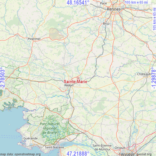
Sainte-Marie GPS coordinates[2]
47° 41' 39.444" North, 2° 0' 6.84" West
| Map corner | latitude | longitude |
|---|---|---|
| Upper-left | 48.16541°, | -2.70503° |
| Center: | 47.69429°, | -2.0019° |
| Lower-right: | 47.21888°, | -1.29878° |
| Map W x H: | 105.2×105.2 km | = 65.4×65.4mi |
| max Lat: | 51.07786° ⇑45.9% North |
| Sainte-Marie: | 47.69429° |
| min Lat: | ⇓54.1% South 41.3874° |
| min Long | Sainte-Marie | max Long |
| -5.08615° | -2.0019° | 9.52242° |
| W 5.1%⇐ | ⇒94.9% E |
Elevation
Elevation of Sainte-Marie is 51 m = 167 ft, and this is 142.7 m = 468 ft below average elevation for this country.
| Max E: |
2333 m = 7654 ft | 81.5% |
| Avg. | 193.7 m = 635 ft | |
| Sainte-Marie | 51 m = 167 ft | |
Min E: |
-1 m = -3 ft | 18.5% |
See also: France elevation on elevation.city.
Geographical zone
Sainte-Marie is located in North temperate zone (between Tropic of Cancer and the Arctic Circle). Distance of this North polar circle is 2098.1 km =1303.7 mi to North.| Distance of | km | miles | from Sainte-Marie |
|---|---|---|---|
| North Pole | 4704 | 2922.9 | to North |
| Arctic Circle | 2098.1 | 1303.7 | to North |
| Tropic Cancer | 2697.2 | 1676 | to South |
| Equator | 5303.1 | 3295.2 | to South |


Nearby cities:
15 places around Sainte-Marie: (largest is in red/bold)
• Avessac
4.7 km =2.9 mi,  168°
168°
• Bains-sur-Oust
5.2 km =3.2 mi,  281°
281°
• Cournon
9.7 km =6 mi,  305°
305°
• Fégréac
12.6 km =7.8 mi,  194°
194°
• Glénac
10.5 km =6.5 mi,  290°
290°
• La Gacilly
12.6 km =7.8 mi, 309°
• Langon
11.7 km =7.3 mi,  75°
75°
• Redon
7.8 km =4.8 mi,  232°
232°
• Renac
3.5 km =2.2 mi,  34°
34°
• Saint-Jean-la-Poterie
11.2 km =7 mi, 234°
• Saint-Just
8.5 km =5.3 mi,  21°
21°
• Saint-Nicolas-de-Redon
7.3 km =4.5 mi,  218°
218°
• Saint-Perreux
8.4 km =5.2 mi,  250°
250°
• Saint-Vincent-sur-Oust
10.8 km =6.7 mi,  273°
273°
• Sixt-sur-Aff
10.8 km =6.7 mi,  327°
327°
Sources, notices
• [Note1] Compared only with cities in France existing in our database
• [Src1] Map data: © OpenStreetMap contributors (CC-BY-SA)
• [Src2] Other city data from geonames.org with taken over terms of usage.
• [Src3] Geographical zone / Annual Mean Temperature by Robert A. Rohde @ Wikipedia
