Renac geodata
Renac (Brittany) is a populated place; located in France in Europe/Paris (GMT+2) time zone. With population of 951 people, there are 9198 cities with bigger population in this country. Compared to other cities in France, 54.6% of cities are located further ↓South; 94.8% of cities are located further →East and 83.1% of cities have higher elevation than Renac. Note1
Administrative division(s):
- Level 1: Brittany
- Level 2: Département d'Ille-et-Vilaine
- Level 3: Arrondissement de Redon
- Level 4: Renac


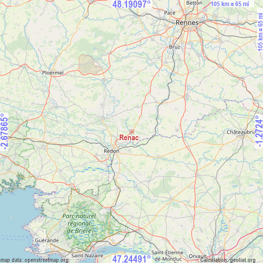
Renac GPS coordinates[2]
47° 43' 12.324" North, 1° 58' 31.908" West
| Map corner | latitude | longitude |
|---|---|---|
| Upper-left | 48.19097°, | -2.67865° |
| Center: | 47.72009°, | -1.97553° |
| Lower-right: | 47.24491°, | -1.2724° |
| Map W x H: | 105.2×105.2 km | = 65.4×65.4mi |
| max Lat: | 51.07786° ⇑45.4% North |
| Renac: | 47.72009° |
| min Lat: | ⇓54.6% South 41.3874° |
| min Long | Renac | max Long |
| -5.08615° | -1.97553° | 9.52242° |
| W 5.2%⇐ | ⇒94.8% E |
Elevation
Elevation of Renac is 47 m = 154 ft, and this is 146.7 m = 481 ft below average elevation for this country.
| Max E: |
2333 m = 7654 ft | 83.1% |
| Avg. | 193.7 m = 635 ft | |
| Renac | 47 m = 154 ft | |
Min E: |
-1 m = -3 ft | 16.9% |
See also: France elevation on elevation.city.
Geographical zone
Renac is located in North temperate zone (between Tropic of Cancer and the Arctic Circle). Distance of this North polar circle is 2095.2 km =1301.9 mi to North.| Distance of | km | miles | from Renac |
|---|---|---|---|
| North Pole | 4701.1 | 2921.1 | to North |
| Arctic Circle | 2095.2 | 1301.9 | to North |
| Tropic Cancer | 2700.1 | 1677.8 | to South |
| Equator | 5306 | 3297 | to South |


Nearby cities:
15 places around Renac: (largest is in red/bold)
• Avessac
7.5 km =4.7 mi,  188°
188°
• Bains-sur-Oust
7.3 km =4.5 mi,  255°
255°
• Bruc-sur-Aff
11 km =6.8 mi,  342°
342°
• Cournon
10.3 km =6.4 mi,  286°
286°
• Glénac
11.8 km =7.3 mi,  273°
273°
• La Chapelle-Gaceline
12.1 km =7.5 mi,  305°
305°
• Langon
9.4 km =5.8 mi,  89°
89°
• Pipriac
10.2 km =6.3 mi,  12°
12°
• Redon
11.2 km =7 mi,  226°
226°
• Saint-Just
5.2 km =3.2 mi, 12°
• Saint-Nicolas-de-Redon
10.8 km =6.7 mi,  217°
217°
• Saint-Perreux
11.4 km =7.1 mi,  240°
240°
• Sainte-Anne-sur-Vilaine
11.3 km =7 mi,  84°
84°
• Sainte-Marie
3.5 km =2.2 mi,  214°
214°
• Sixt-sur-Aff
9.9 km =6.2 mi, 309°
Sources, notices
• [Note1] Compared only with cities in France existing in our database
• [Src1] Map data: © OpenStreetMap contributors (CC-BY-SA)
• [Src2] Other city data from geonames.org with taken over terms of usage.
• [Src3] Geographical zone / Annual Mean Temperature by Robert A. Rohde @ Wikipedia
