Avessac geodata
Avessac (Pays de la Loire) is a populated place; located in France in Europe/Paris (GMT+2) time zone. With population of 2,346 people, there are 4117 cities with bigger population in this country. Compared to other cities in France, 53.5% of cities are located further ↓South; 94.8% of cities are located further →East and 80.2% of cities have higher elevation than Avessac. Note1
Administrative division(s):
- Level 1: Pays de la Loire
- Level 2: Loire-Atlantique
- Level 3: Arrondissement of Châteaubriant-Ancenis
- Level 4: Avessac


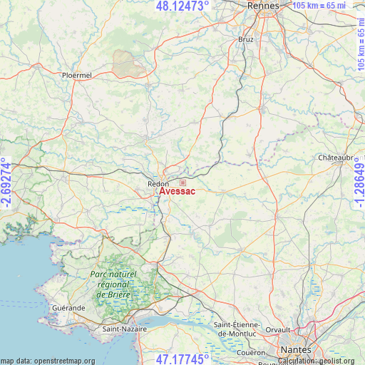
Avessac GPS coordinates[2]
47° 39' 11.664" North, 1° 59' 22.596" West
| Map corner | latitude | longitude |
|---|---|---|
| Upper-left | 48.12473°, | -2.69274° |
| Center: | 47.65324°, | -1.98961° |
| Lower-right: | 47.17745°, | -1.28649° |
| Map W x H: | 105.3×105.3 km | = 65.4×65.4mi |
| max Lat: | 51.07786° ⇑46.5% North |
| Avessac: | 47.65324° |
| min Lat: | ⇓53.5% South 41.3874° |
| min Long | Avessac | max Long |
| -5.08615° | -1.98961° | 9.52242° |
| W 5.2%⇐ | ⇒94.8% E |
Elevation
Elevation of Avessac is 54 m = 177 ft, and this is 139.7 m = 458 ft below average elevation for this country.
| Max E: |
2333 m = 7654 ft | 80.2% |
| Avg. | 193.7 m = 635 ft | |
| Avessac | 54 m = 177 ft | |
Min E: |
-1 m = -3 ft | 19.8% |
See also: France elevation on elevation.city.
Geographical zone
Avessac is located in North temperate zone (between Tropic of Cancer and the Arctic Circle). Distance of this North polar circle is 2102.6 km =1306.5 mi to North.| Distance of | km | miles | from Avessac |
|---|---|---|---|
| North Pole | 4708.5 | 2925.7 | to North |
| Arctic Circle | 2102.6 | 1306.5 | to North |
| Tropic Cancer | 2692.6 | 1673.1 | to South |
| Equator | 5298.5 | 3292.3 | to South |


Nearby cities:
15 places around Avessac: (largest is in red/bold)
• Allaire
13.1 km =8.1 mi,  262°
262°
• Bains-sur-Oust
8.2 km =5.1 mi,  312°
312°
• Fégréac
8.6 km =5.3 mi,  208°
208°
• Guémené-Penfao
11.9 km =7.4 mi,  100°
100°
• Langon
12.8 km =8 mi,  54°
54°
• Redon
7.1 km =4.4 mi,  268°
268°
• Renac
7.5 km =4.7 mi,  8°
8°
• Rieux
10.8 km =6.7 mi,  235°
235°
• Saint-Jean-la-Poterie
10.3 km =6.4 mi, 259°
• Saint-Just
12.7 km =7.9 mi, 9°
• Saint-Nicolas-de-Redon
5.6 km =3.5 mi, 258°
• Saint-Perreux
9.1 km =5.7 mi,  281°
281°
• Saint-Vincent-sur-Oust
12.9 km =8 mi,  293°
293°
• Sainte-Marie
4.7 km =2.9 mi,  348°
348°
• Sévérac
13.1 km =8.1 mi, 209°
Sources, notices
• [Note1] Compared only with cities in France existing in our database
• [Src1] Map data: © OpenStreetMap contributors (CC-BY-SA)
• [Src2] Other city data from geonames.org with taken over terms of usage.
• [Src3] Geographical zone / Annual Mean Temperature by Robert A. Rohde @ Wikipedia
