Saint-Nazaire-de-Pézan geodata
Saint-Nazaire-de-Pézan (Occitanie) is a populated place; located in France in Europe/Paris (GMT+2) time zone. With population of 604 people, there are 13253 cities with bigger population in this country. Compared to other cities in France, 91.3% of cities are located further ↑North; 69% of cities are located further ←West and 99.3% of cities have higher elevation than Saint-Nazaire-de-Pézan. Note1
Administrative division(s):
- Level 1: Occitanie
- Level 2: Département de l'Hérault
- Level 3: Arrondissement of Montpellier
- Level 4: Saint-Nazaire-de-Pézan
Current local time in Saint-Nazaire-de-Pézan:
11:04 AM, WednesdayDifference from your time zone: hours


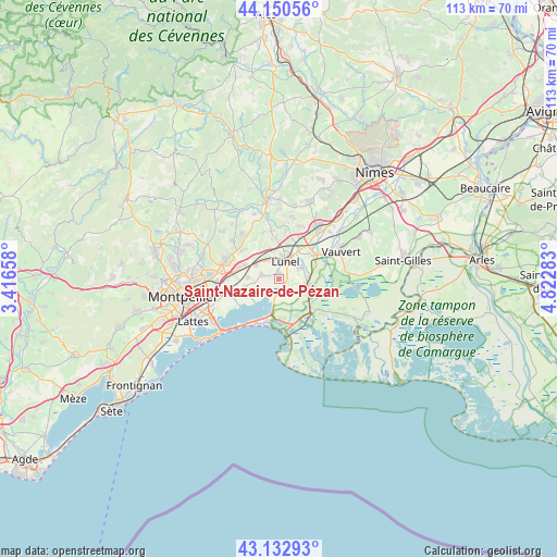
Saint-Nazaire-de-Pézan GPS coordinates[2]
43° 38' 38.04" North, 4° 7' 10.92" East
| Map corner | latitude | longitude |
|---|---|---|
| Upper-left | 44.15056°, | 3.41658° |
| Center: | 43.6439°, | 4.1197° |
| Lower-right: | 43.13293°, | 4.82283° |
| Map W x H: | 113.1×113.1 km | = 70.3×70.3mi |
| max Lat: | 51.07786° ⇑91.3% North |
| Saint-Nazaire-de-Pézan: | 43.6439° |
| min Lat: | ⇓8.7% South 41.3874° |
| min Long | Saint-Nazaire-d | max Long |
| -5.08615° | 4.1197° | 9.52242° |
| W 69%⇐ | ⇒31% E |
Elevation
Elevation of Saint-Nazaire-de-Pézan is 5 m = 16 ft, and this is 188.7 m = 619 ft below average elevation for this country.
| Max E: |
2333 m = 7654 ft | 99.3% |
| Avg. | 193.7 m = 635 ft | |
| Saint-Nazaire-de-Pézan | 5 m = 16 ft | |
Min E: |
-1 m = -3 ft | 0.7% |
See also: France elevation on elevation.city.
Geographical zone
Saint-Nazaire-de-Pézan is located in North temperate zone (between Tropic of Cancer and the Arctic Circle). Distance of this Northern Tropic circle is 2246.8 km =1396.1 mi to South.| Distance of | km | miles | from Saint-Nazaire-de-Pézan |
|---|---|---|---|
| North Pole | 5154.3 | 3202.7 | to North |
| Arctic Circle | 2548.4 | 1583.5 | to North |
| Tropic Cancer | 2246.8 | 1396.1 | to South |
| Equator | 4852.7 | 3015.3 | to South |


Nearby cities:
15 places around Saint-Nazaire-de-Pézan: (largest is in red/bold)
• Aimargues
8.5 km =5.3 mi,  58°
58°
• Baillargues
8.5 km =5.3 mi,  284°
284°
• Candillargues
4.8 km =3 mi,  237°
237°
• Gallargues-le-Montueux
8.9 km =5.5 mi,  25°
25°
• Lansargues
3.7 km =2.3 mi, 283°
• Lunel
4 km =2.5 mi,  19°
19°
• Lunel-Viel
4.5 km =2.8 mi,  330°
330°
• Marsillargues
5 km =3.1 mi, 62°
• Mudaison
7 km =4.3 mi,  260°
260°
• Saint-Brès
7.6 km =4.7 mi,  290°
290°
• Saint-Geniès-des-Mourgues
9 km =5.6 mi,  311°
311°
• Saint-Just
1.6 km =1 mi,  345°
345°
• Saturargues
8.8 km =5.5 mi,  356°
356°
• Valergues
5.4 km =3.4 mi,  299°
299°
• Vérargues
8.2 km =5.1 mi, 348°
Sources, notices
• [Note1] Compared only with cities in France existing in our database
• [Src1] Map data: © OpenStreetMap contributors (CC-BY-SA)
• [Src2] Other city data from geonames.org with taken over terms of usage.
• [Src3] Geographical zone / Annual Mean Temperature by Robert A. Rohde @ Wikipedia
