Lansargues geodata
Lansargues (Occitanie) is a populated place; located in France in Europe/Paris (GMT+2) time zone. With population of 2,629 people, there are 3706 cities with bigger population in this country. Compared to other cities in France, 91.2% of cities are located further ↑North; 68.5% of cities are located further ←West and 97.4% of cities have higher elevation than Lansargues. Note1
Administrative division(s):
- Level 1: Occitanie
- Level 2: Département de l'Hérault
- Level 3: Arrondissement of Montpellier
- Level 4: Lansargues


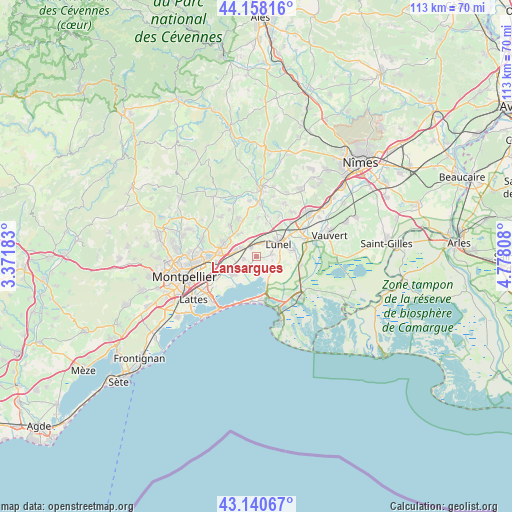
Lansargues GPS coordinates[2]
43° 39' 5.652" North, 4° 4' 29.82" East
| Map corner | latitude | longitude |
|---|---|---|
| Upper-left | 44.15816°, | 3.37183° |
| Center: | 43.65157°, | 4.07495° |
| Lower-right: | 43.14067°, | 4.77808° |
| Map W x H: | 113.1×113.1 km | = 70.3×70.3mi |
| max Lat: | 51.07786° ⇑91.2% North |
| Lansargues: | 43.65157° |
| min Lat: | ⇓8.8% South 41.3874° |
| min Long | Lansargues | max Long |
| -5.08615° | 4.07495° | 9.52242° |
| W 68.5%⇐ | ⇒31.5% E |
Elevation
Elevation of Lansargues is 10 m = 33 ft, and this is 183.7 m = 603 ft below average elevation for this country.
| Max E: |
2333 m = 7654 ft | 97.4% |
| Avg. | 193.7 m = 635 ft | |
| Lansargues | 10 m = 33 ft | |
Min E: |
-1 m = -3 ft | 2.6% |
See also: France elevation on elevation.city.
Geographical zone
Lansargues is located in North temperate zone (between Tropic of Cancer and the Arctic Circle). Distance of this Northern Tropic circle is 2247.7 km =1396.7 mi to South.| Distance of | km | miles | from Lansargues |
|---|---|---|---|
| North Pole | 5153.5 | 3202.2 | to North |
| Arctic Circle | 2547.6 | 1583 | to North |
| Tropic Cancer | 2247.7 | 1396.7 | to South |
| Equator | 4853.6 | 3015.9 | to South |


Nearby cities:
15 places around Lansargues: (largest is in red/bold)
• Baillargues
4.8 km =3 mi,  284°
284°
• Candillargues
3.5 km =2.2 mi,  187°
187°
• Castries
8.1 km =5 mi,  292°
292°
• Lunel
5.7 km =3.5 mi,  59°
59°
• Lunel-Viel
3.4 km =2.1 mi,  24°
24°
• Marsillargues
8.1 km =5 mi,  80°
80°
• Mauguio
6.6 km =4.1 mi,  235°
235°
• Mudaison
3.9 km =2.4 mi, 238°
• Saint-Brès
3.9 km =2.4 mi,  296°
296°
• Saint-Christol
8.5 km =5.3 mi,  2°
2°
• Saint-Geniès-des-Mourgues
6 km =3.7 mi,  328°
328°
• Saint-Just
3.3 km =2.1 mi, 77°
• Saint-Nazaire-de-Pézan
3.7 km =2.3 mi,  103°
103°
• Valergues
2.2 km =1.4 mi, 329°
• Vérargues
7.5 km =4.7 mi, 15°
Sources, notices
• [Note1] Compared only with cities in France existing in our database
• [Src1] Map data: © OpenStreetMap contributors (CC-BY-SA)
• [Src2] Other city data from geonames.org with taken over terms of usage.
• [Src3] Geographical zone / Annual Mean Temperature by Robert A. Rohde @ Wikipedia
