Marsillargues geodata
Marsillargues (Occitanie) is a populated place; located in France in Europe/Paris (GMT+2) time zone. With population of 5,983 people, there are 1656 cities with bigger population in this country. Compared to other cities in France, 91% of cities are located further ↑North; 69.5% of cities are located further ←West and 99% of cities have higher elevation than Marsillargues. Note1
Administrative division(s):
- Level 1: Occitanie
- Level 2: Département de l'Hérault
- Level 3: Arrondissement of Montpellier
- Level 4: Marsillargues


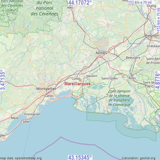
Marsillargues GPS coordinates[2]
43° 39' 51.264" North, 4° 10' 28.128" East
| Map corner | latitude | longitude |
|---|---|---|
| Upper-left | 44.17072°, | 3.47135° |
| Center: | 43.66424°, | 4.17448° |
| Lower-right: | 43.15345°, | 4.8776° |
| Map W x H: | 113.1×113.1 km | = 70.3×70.3mi |
| max Lat: | 51.07786° ⇑91% North |
| Marsillargues: | 43.66424° |
| min Lat: | ⇓9% South 41.3874° |
| min Long | Marsillargues | max Long |
| -5.08615° | 4.17448° | 9.52242° |
| W 69.5%⇐ | ⇒30.5% E |
Elevation
Elevation of Marsillargues is 6 m = 20 ft, and this is 187.7 m = 616 ft below average elevation for this country.
| Max E: |
2333 m = 7654 ft | 99% |
| Avg. | 193.7 m = 635 ft | |
| Marsillargues | 6 m = 20 ft | |
Min E: |
-1 m = -3 ft | 1% |
See also: France elevation on elevation.city.
Geographical zone
Marsillargues is located in North temperate zone (between Tropic of Cancer and the Arctic Circle). Distance of this Northern Tropic circle is 2249.1 km =1397.5 mi to South.| Distance of | km | miles | from Marsillargues |
|---|---|---|---|
| North Pole | 5152.1 | 3201.4 | to North |
| Arctic Circle | 2546.2 | 1582.1 | to North |
| Tropic Cancer | 2249.1 | 1397.5 | to South |
| Equator | 4855 | 3016.8 | to South |


Nearby cities:
15 places around Marsillargues: (largest is in red/bold)
• Aigues-Vives
8.2 km =5.1 mi,  3°
3°
• Aimargues
3.6 km =2.2 mi,  51°
51°
• Codognan
8.3 km =5.2 mi,  27°
27°
• Gallargues-le-Montueux
5.9 km =3.7 mi,  353°
353°
• Lansargues
8.1 km =5 mi,  260°
260°
• Le Cailar
5.2 km =3.2 mi,  71°
71°
• Lunel
3.4 km =2.1 mi,  296°
296°
• Lunel-Viel
6.8 km =4.2 mi,  283°
283°
• Mus
8.6 km =5.3 mi,  15°
15°
• Saint-Just
4.9 km =3 mi, 261°
• Saint-Nazaire-de-Pézan
5 km =3.1 mi,  242°
242°
• Saturargues
8.2 km =5.1 mi,  322°
322°
• Vauvert
8.9 km =5.5 mi, 67°
• Villetelle
8 km =5 mi,  337°
337°
• Vérargues
8.4 km =5.2 mi,  314°
314°
Sources, notices
• [Note1] Compared only with cities in France existing in our database
• [Src1] Map data: © OpenStreetMap contributors (CC-BY-SA)
• [Src2] Other city data from geonames.org with taken over terms of usage.
• [Src3] Geographical zone / Annual Mean Temperature by Robert A. Rohde @ Wikipedia
