Saint-Malo-de-Guersac geodata
Saint-Malo-de-Guersac (Pays de la Loire) is a populated place; located in France in Europe/Paris (GMT+2) time zone. With population of 3,408 people, there are 2856 cities with bigger population in this country. Compared to other cities in France, 50.7% of cities are located further ↑North; 95.5% of cities are located further →East and 97% of cities have higher elevation than Saint-Malo-de-Guersac. Note1
Administrative division(s):
- Level 1: Pays de la Loire
- Level 2: Loire-Atlantique
- Level 3: Arrondissement de Saint-Nazaire
- Level 4: Saint-Malo-de-Guersac


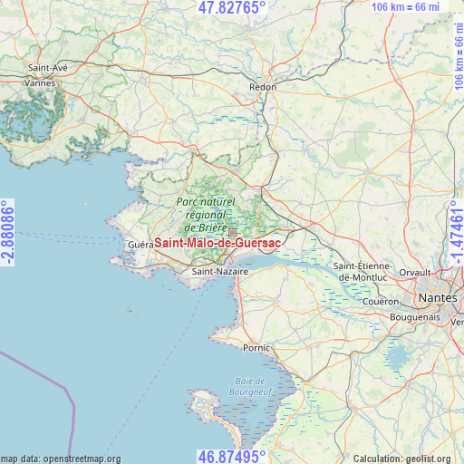
Saint-Malo-de-Guersac GPS coordinates[2]
47° 21' 12.42" North, 2° 10' 39.828" West
| Map corner | latitude | longitude |
|---|---|---|
| Upper-left | 47.82765°, | -2.88086° |
| Center: | 47.35345°, | -2.17773° |
| Lower-right: | 46.87495°, | -1.47461° |
| Map W x H: | 105.9×105.9 km | = 65.8×65.8mi |
| max Lat: | 51.07786° ⇑50.7% North |
| Saint-Malo-de-Guersac: | 47.35345° |
| min Lat: | ⇓49.3% South 41.3874° |
| min Long | Saint-Malo-de-G | max Long |
| -5.08615° | -2.17773° | 9.52242° |
| W 4.5%⇐ | ⇒95.5% E |
Elevation
Elevation of Saint-Malo-de-Guersac is 11 m = 36 ft, and this is 182.7 m = 599 ft below average elevation for this country.
| Max E: |
2333 m = 7654 ft | 97% |
| Avg. | 193.7 m = 635 ft | |
| Saint-Malo-de-Guersac | 11 m = 36 ft | |
Min E: |
-1 m = -3 ft | 3% |
See also: France elevation on elevation.city.
Geographical zone
Saint-Malo-de-Guersac is located in North temperate zone (between Tropic of Cancer and the Arctic Circle). Distance of this North polar circle is 2136 km =1327.2 mi to North.| Distance of | km | miles | from Saint-Malo-de-Guersac |
|---|---|---|---|
| North Pole | 4741.9 | 2946.5 | to North |
| Arctic Circle | 2136 | 1327.2 | to North |
| Tropic Cancer | 2659.3 | 1652.4 | to South |
| Equator | 5265.2 | 3271.6 | to South |


Nearby cities:
15 places around Saint-Malo-de-Guersac: (largest is in red/bold)
• Besné
8.4 km =5.2 mi,  51°
51°
• Corsept
12.3 km =7.6 mi,  133°
133°
• Crossac
6.4 km =4 mi,  5°
5°
• Donges
8.6 km =5.3 mi,  116°
116°
• La Chapelle-des-Marais
11.5 km =7.1 mi,  336°
336°
• Le Pin
0.9 km =0.6 mi,  114°
114°
• Montoir-de-Bretagne
3.3 km =2.1 mi,  142°
142°
• Pontchâteau
11.5 km =7.1 mi,  35°
35°
• Saint-André-des-Eaux
10.9 km =6.8 mi,  246°
246°
• Saint-Brevin-les-Pins
11.5 km =7.1 mi,  175°
175°
• Saint-Joachim
3.5 km =2.2 mi, 341°
• Saint-Lyphard
10.9 km =6.8 mi,  297°
297°
• Saint-Nazaire
8.6 km =5.3 mi,  196°
196°
• Sainte-Reine-de-Bretagne
9.8 km =6.1 mi,  353°
353°
• Trignac
4 km =2.5 mi,  192°
192°
Sources, notices
• [Note1] Compared only with cities in France existing in our database
• [Src1] Map data: © OpenStreetMap contributors (CC-BY-SA)
• [Src2] Other city data from geonames.org with taken over terms of usage.
• [Src3] Geographical zone / Annual Mean Temperature by Robert A. Rohde @ Wikipedia
