Saint-Memmie geodata
Saint-Memmie (Grand Est) is a populated place; located in France in Europe/Paris (GMT+2) time zone. With population of 5,833 people, there are 1691 cities with bigger population in this country. Compared to other cities in France, 78.6% of cities are located further ↓South; 71.3% of cities are located further ←West and 65.3% of cities have higher elevation than Saint-Memmie. Note1
Administrative division(s):
- Level 1: Grand Est
- Level 2: Marne
- Level 3: Arrondissement de Châlons-en-Champagne
- Level 4: Saint-Memmie


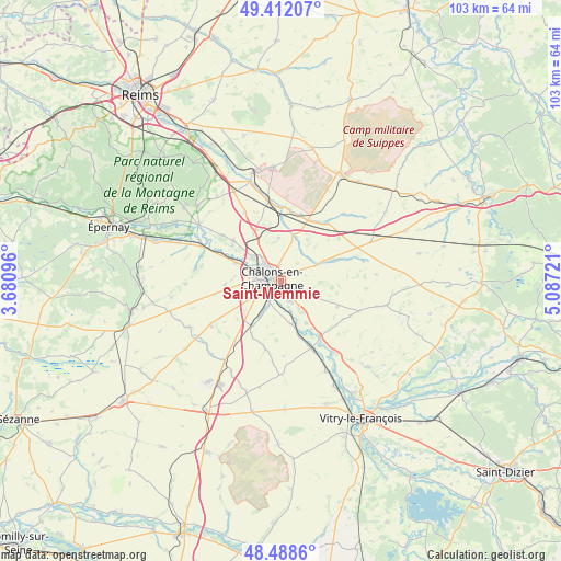
Saint-Memmie GPS coordinates[2]
48° 57' 8.892" North, 4° 23' 2.724" East
| Map corner | latitude | longitude |
|---|---|---|
| Upper-left | 49.41207°, | 3.68096° |
| Center: | 48.95247°, | 4.38409° |
| Lower-right: | 48.4886°, | 5.08721° |
| Map W x H: | 102.7×102.7 km | = 63.8×63.8mi |
| max Lat: | 51.07786° ⇑21.4% North |
| Saint-Memmie: | 48.95247° |
| min Lat: | ⇓78.6% South 41.3874° |
| min Long | Saint-Memmie | max Long |
| -5.08615° | 4.38409° | 9.52242° |
| W 71.3%⇐ | ⇒28.7% E |
Elevation
Elevation of Saint-Memmie is 89 m = 292 ft, and this is 104.7 m = 344 ft below average elevation for this country.
| Max E: |
2333 m = 7654 ft | 65.3% |
| Avg. | 193.7 m = 635 ft | |
| Saint-Memmie | 89 m = 292 ft | |
Min E: |
-1 m = -3 ft | 34.7% |
See also: France elevation on elevation.city.
Geographical zone
Saint-Memmie is located in North temperate zone (between Tropic of Cancer and the Arctic Circle). Distance of this North polar circle is 1958.2 km =1216.8 mi to North.| Distance of | km | miles | from Saint-Memmie |
|---|---|---|---|
| North Pole | 4564.1 | 2836 | to North |
| Arctic Circle | 1958.2 | 1216.8 | to North |
| Tropic Cancer | 2837.1 | 1762.9 | to South |
| Equator | 5443 | 3382.1 | to South |


Nearby cities:
15 places around Saint-Memmie: (largest is in red/bold)
• Châlons-en-Champagne
1.2 km =0.7 mi,  277°
277°
• Compertrix
3 km =1.9 mi,  246°
246°
• Courtisols
10.4 km =6.5 mi,  68°
68°
• Fagnières
5.1 km =3.2 mi, 284°
• Juvigny
11.5 km =7.1 mi,  310°
310°
• La Veuve
9.9 km =6.2 mi,  330°
330°
• L’Épine
7 km =4.3 mi, 65°
• Mairy-sur-Marne
8.1 km =5 mi,  165°
165°
• Matougues
11.3 km =7 mi,  293°
293°
• Moncetz-Longevas
5.7 km =3.5 mi,  147°
147°
• Pogny
12.8 km =8 mi, 145°
• Recy
6.5 km =4 mi, 308°
• Saint-Germain-la-Ville
9.1 km =5.7 mi, 149°
• Saint-Martin-sur-le-Pré
4.3 km =2.7 mi, 310°
• Sarry
4.1 km =2.5 mi,  156°
156°
Sources, notices
• [Note1] Compared only with cities in France existing in our database
• [Src1] Map data: © OpenStreetMap contributors (CC-BY-SA)
• [Src2] Other city data from geonames.org with taken over terms of usage.
• [Src3] Geographical zone / Annual Mean Temperature by Robert A. Rohde @ Wikipedia
