L’Épine geodata
L’Épine (Grand Est) is a populated place; located in France in Europe/Paris (GMT+2) time zone. With population of 635 people, there are 12740 cities with bigger population in this country. Compared to other cities in France, 79.2% of cities are located further ↓South; 71.9% of cities are located further ←West and 54.5% of cities have lower elevation than L’Épine. Note1
Administrative division(s):
- Level 1: Grand Est
- Level 2: Marne
- Level 3: Arrondissement de Châlons-en-Champagne
- Level 4: L'Épine


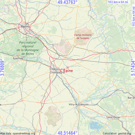
L’Épine GPS coordinates[2]
48° 58' 41.772" North, 4° 28' 16.392" East
| Map corner | latitude | longitude |
|---|---|---|
| Upper-left | 49.43763°, | 3.76809° |
| Center: | 48.97827°, | 4.47122° |
| Lower-right: | 48.51464°, | 5.17434° |
| Map W x H: | 102.6×102.6 km | = 63.8×63.8mi |
| max Lat: | 51.07786° ⇑20.8% North |
| L’Épine: | 48.97827° |
| min Lat: | ⇓79.2% South 41.3874° |
| min Long | L’Épine | max Long |
| -5.08615° | 4.47122° | 9.52242° |
| W 71.9%⇐ | ⇒28.1% E |
Elevation
Elevation of L’Épine is 148 m = 486 ft, and this is 45.7 m = 150 ft below average elevation for this country.
| Max E: |
2333 m = 7654 ft | 45.5% |
| Avg. | 193.7 m = 635 ft | |
| L’Épine | 148 m = 486 ft | |
Min E: |
-1 m = -3 ft | 54.5% |
See also: France elevation on elevation.city.
Geographical zone
L’Épine is located in North temperate zone (between Tropic of Cancer and the Arctic Circle). Distance of this North polar circle is 1955.3 km =1215 mi to North.| Distance of | km | miles | from L’Épine |
|---|---|---|---|
| North Pole | 4561.2 | 2834.2 | to North |
| Arctic Circle | 1955.3 | 1215 | to North |
| Tropic Cancer | 2840 | 1764.7 | to South |
| Equator | 5445.9 | 3383.9 | to South |


Nearby cities:
15 places around L’Épine: (largest is in red/bold)
• Châlons-en-Champagne
8.1 km =5 mi,  250°
250°
• Compertrix
10 km =6.2 mi, 246°
• Courtisols
3.5 km =2.2 mi,  74°
74°
• Fagnières
11.4 km =7.1 mi,  261°
261°
• Juvigny
15.8 km =9.8 mi,  286°
286°
• La Chaussée-sur-Marne
16.5 km =10.3 mi,  166°
166°
• La Veuve
12.7 km =7.9 mi,  297°
297°
• Mairy-sur-Marne
11.6 km =7.2 mi,  202°
202°
• Moncetz-Longevas
8.3 km =5.2 mi, 203°
• Pogny
13.4 km =8.3 mi,  176°
176°
• Recy
11.5 km =7.1 mi,  275°
275°
• Saint-Germain-la-Ville
10.8 km =6.7 mi,  189°
189°
• Saint-Martin-sur-le-Pré
9.6 km =6 mi,  269°
269°
• Saint-Memmie
7 km =4.3 mi, 245°
• Sarry
8.2 km =5.1 mi,  215°
215°
Sources, notices
• [Note1] Compared only with cities in France existing in our database
• [Src1] Map data: © OpenStreetMap contributors (CC-BY-SA)
• [Src2] Other city data from geonames.org with taken over terms of usage.
• [Src3] Geographical zone / Annual Mean Temperature by Robert A. Rohde @ Wikipedia
