Saint-Maximin-la-Sainte-Baume geodata
Saint-Maximin-la-Sainte-Baume (Provence-Alpes-Côte d'Azur) is a populated place; located in France in Europe/Paris (GMT+2) time zone. With population of 15,225 people, there are 635 cities with bigger population in this country. Compared to other cities in France, 93.7% of cities are located further ↑North; 85.6% of cities are located further ←West and 82.3% of cities have lower elevation than Saint-Maximin-la-Sainte-Baume. Note1
Administrative division(s):
- Level 1: Provence-Alpes-Côte d'Azur
- Level 2: Var
- Level 3: Arrondissement de Brignoles
- Level 4: Saint-Maximin-la-Sainte-Baume
Current local time in Saint-Maximin-la-Sainte-Baume:
03:22 AM, WednesdayDifference from your time zone: hours


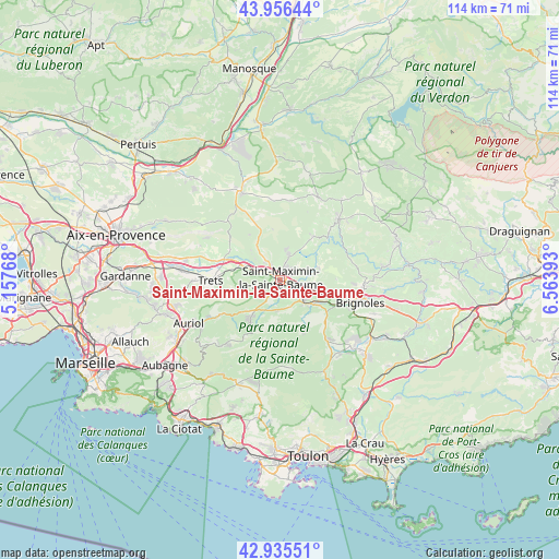
Saint-Maximin-la-Sainte-Baume GPS coordinates[2]
43° 26' 53.268" North, 5° 51' 38.916" East
| Map corner | latitude | longitude |
|---|---|---|
| Upper-left | 43.95644°, | 5.15768° |
| Center: | 43.44813°, | 5.86081° |
| Lower-right: | 42.93551°, | 6.56393° |
| Map W x H: | 113.5×113.5 km | = 70.5×70.5mi |
| max Lat: | 51.07786° ⇑93.7% North |
| Saint-Maximin-la-Sainte-Baume: | 43.44813° |
| min Lat: | ⇓6.3% South 41.3874° |
| min Long | Saint-Maximin-l | max Long |
| -5.08615° | 5.86081° | 9.52242° |
| W 85.6%⇐ | ⇒14.4% E |
Elevation
Elevation of Saint-Maximin-la-Sainte-Baume is 313 m = 1027 ft, and this is 119.3 m = 391 ft above average elevation for this country.
| Max E: |
2333 m = 7654 ft | 17.7% |
| Saint-Maximin-la-Sainte-Baume | 313 m 1027 ft | |
| Avg. | 193.7 m = 635 ft | |
Min E: |
-1 m = -3 ft | 82.3% |
See also: France elevation on elevation.city.
Geographical zone
Saint-Maximin-la-Sainte-Baume is located in North temperate zone (between Tropic of Cancer and the Arctic Circle). Distance of this Northern Tropic circle is 2225.1 km =1382.6 mi to South.| Distance of | km | miles | from Saint-Maximin-la-Sainte-Baume |
|---|---|---|---|
| North Pole | 5176.1 | 3216.3 | to North |
| Arctic Circle | 2570.2 | 1597 | to North |
| Tropic Cancer | 2225.1 | 1382.6 | to South |
| Equator | 4831 | 3001.8 | to South |


Nearby cities:
15 places around Saint-Maximin-la-Sainte-Baume: (largest is in red/bold)
• Barjols
17 km =10.6 mi,  44°
44°
• Bras
8 km =5 mi,  71°
71°
• Brignoles
16.9 km =10.5 mi,  106°
106°
• Brue-Auriac
11.2 km =7 mi, 36°
• La Celle
15.4 km =9.6 mi, 112°
• La Roquebrussanne
15.2 km =9.4 mi,  142°
142°
• Le Val
17.2 km =10.7 mi,  93°
93°
• Mazaugues
12.1 km =7.5 mi,  156°
156°
• Nans-les-Pins
10.7 km =6.6 mi,  216°
216°
• Pourcieux
6.6 km =4.1 mi,  292°
292°
• Pourrières
12.1 km =7.5 mi,  302°
302°
• Rougiers
6.3 km =3.9 mi,  187°
187°
• Saint-Zacharie
14.2 km =8.8 mi,  240°
240°
• Tourves
6.8 km =4.2 mi,  131°
131°
• Trets
14.3 km =8.9 mi,  270°
270°
Sources, notices
• [Note1] Compared only with cities in France existing in our database
• [Src1] Map data: © OpenStreetMap contributors (CC-BY-SA)
• [Src2] Other city data from geonames.org with taken over terms of usage.
• [Src3] Geographical zone / Annual Mean Temperature by Robert A. Rohde @ Wikipedia
