Pourrières geodata
Pourrières (Provence-Alpes-Côte d'Azur) is a populated place; located in France in Europe/Paris (GMT+2) time zone. With population of 4,292 people, there are 2296 cities with bigger population in this country. Compared to other cities in France, 93% of cities are located further ↑North; 84.6% of cities are located further ←West and 81.4% of cities have lower elevation than Pourrières. Note1
Administrative division(s):
- Level 1: Provence-Alpes-Côte d'Azur
- Level 2: Var
- Level 3: Arrondissement de Brignoles
- Level 4: Pourrières


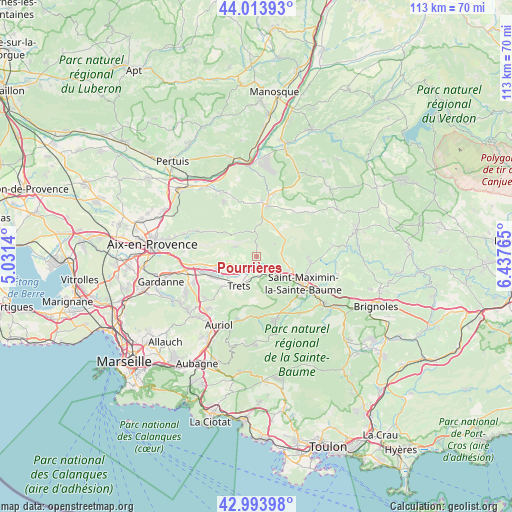
Pourrières GPS coordinates[2]
43° 30' 21.996" North, 5° 44' 4.272" East
| Map corner | latitude | longitude |
|---|---|---|
| Upper-left | 44.01393°, | 5.0314° |
| Center: | 43.50611°, | 5.73452° |
| Lower-right: | 42.99398°, | 6.43765° |
| Map W x H: | 113.4×113.4 km | = 70.5×70.5mi |
| max Lat: | 51.07786° ⇑93% North |
| Pourrières: | 43.50611° |
| min Lat: | ⇓7% South 41.3874° |
| min Long | Pourrières | max Long |
| -5.08615° | 5.73452° | 9.52242° |
| W 84.6%⇐ | ⇒15.4% E |
Elevation
Elevation of Pourrières is 304 m = 997 ft, and this is 110.3 m = 362 ft above average elevation for this country.
| Max E: |
2333 m = 7654 ft | 18.6% |
| Pourrières | 304 m 997 ft | |
| Avg. | 193.7 m = 635 ft | |
Min E: |
-1 m = -3 ft | 81.4% |
See also: France elevation on elevation.city.
Geographical zone
Pourrières is located in North temperate zone (between Tropic of Cancer and the Arctic Circle). Distance of this Northern Tropic circle is 2231.5 km =1386.6 mi to South.| Distance of | km | miles | from Pourrières |
|---|---|---|---|
| North Pole | 5169.6 | 3212.2 | to North |
| Arctic Circle | 2563.7 | 1593 | to North |
| Tropic Cancer | 2231.5 | 1386.6 | to South |
| Equator | 4837.4 | 3005.8 | to South |


Nearby cities:
15 places around Pourrières: (largest is in red/bold)
• Beaurecueil
15.2 km =9.4 mi,  272°
272°
• Belcodène
14.7 km =9.1 mi,  232°
232°
• Châteauneuf-le-Rouge
13.5 km =8.4 mi,  262°
262°
• Fuveau
15 km =9.3 mi,  248°
248°
• Nans-les-Pins
15.5 km =9.6 mi,  165°
165°
• Peynier
9.9 km =6.2 mi, 229°
• Pourcieux
5.7 km =3.5 mi,  133°
133°
• Puyloubier
5.1 km =3.2 mi,  294°
294°
• Rians
11.4 km =7.1 mi,  9°
9°
• Rougiers
15.8 km =9.8 mi,  143°
143°
• Rousset
9.6 km =6 mi, 254°
• Saint-Maximin-la-Sainte-Baume
12.1 km =7.5 mi,  122°
122°
• Saint-Zacharie
13.6 km =8.5 mi,  189°
189°
• Trets
7.7 km =4.8 mi,  212°
212°
• Vauvenargues
12.2 km =7.6 mi,  296°
296°
Sources, notices
• [Note1] Compared only with cities in France existing in our database
• [Src1] Map data: © OpenStreetMap contributors (CC-BY-SA)
• [Src2] Other city data from geonames.org with taken over terms of usage.
• [Src3] Geographical zone / Annual Mean Temperature by Robert A. Rohde @ Wikipedia
