Saint-Zacharie geodata
Saint-Zacharie (Provence-Alpes-Côte d'Azur) is a populated place; located in France in Europe/Paris (GMT+2) time zone. With population of 4,506 people, there are 2188 cities with bigger population in this country. Compared to other cities in France, 94.4% of cities are located further ↑North; 84.4% of cities are located further ←West and 78.6% of cities have lower elevation than Saint-Zacharie. Note1
Administrative division(s):
- Level 1: Provence-Alpes-Côte d'Azur
- Level 2: Var
- Level 3: Arrondissement de Brignoles
- Level 4: Saint-Zacharie


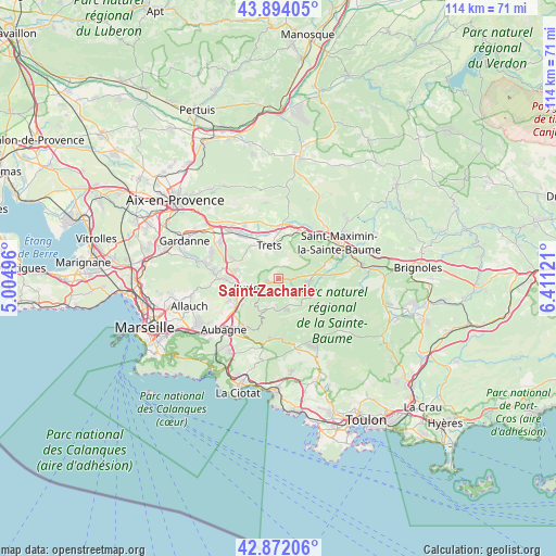
Saint-Zacharie GPS coordinates[2]
43° 23' 6.756" North, 5° 42' 29.088" East
| Map corner | latitude | longitude |
|---|---|---|
| Upper-left | 43.89405°, | 5.00496° |
| Center: | 43.38521°, | 5.70808° |
| Lower-right: | 42.87206°, | 6.41121° |
| Map W x H: | 113.6×113.6 km | = 70.6×70.6mi |
| max Lat: | 51.07786° ⇑94.4% North |
| Saint-Zacharie: | 43.38521° |
| min Lat: | ⇓5.6% South 41.3874° |
| min Long | Saint-Zacharie | max Long |
| -5.08615° | 5.70808° | 9.52242° |
| W 84.4%⇐ | ⇒15.6% E |
Elevation
Elevation of Saint-Zacharie is 278 m = 912 ft, and this is 84.3 m = 277 ft above average elevation for this country.
| Max E: |
2333 m = 7654 ft | 21.4% |
| Saint-Zacharie | 278 m 912 ft | |
| Avg. | 193.7 m = 635 ft | |
Min E: |
-1 m = -3 ft | 78.6% |
See also: France elevation on elevation.city.
Geographical zone
Saint-Zacharie is located in North temperate zone (between Tropic of Cancer and the Arctic Circle). Distance of this Northern Tropic circle is 2218.1 km =1378.3 mi to South.| Distance of | km | miles | from Saint-Zacharie |
|---|---|---|---|
| North Pole | 5183.1 | 3220.6 | to North |
| Arctic Circle | 2577.2 | 1601.4 | to North |
| Tropic Cancer | 2218.1 | 1378.3 | to South |
| Equator | 4824 | 2997.5 | to South |


Nearby cities:
15 places around Saint-Zacharie: (largest is in red/bold)
• Auriol
6.2 km =3.9 mi,  255°
255°
• Belcodène
10.7 km =6.6 mi,  295°
295°
• Cuges-les-Pins
12.2 km =7.6 mi,  183°
183°
• Gémenos
11.7 km =7.3 mi,  213°
213°
• La Bouilladisse
9.4 km =5.8 mi,  277°
277°
• La Destrousse
8.4 km =5.2 mi, 262°
• Nans-les-Pins
6.2 km =3.9 mi,  105°
105°
• Peynier
8.9 km =5.5 mi,  322°
322°
• Peypin
10.5 km =6.5 mi,  269°
269°
• Plan-d'Aups-Sainte-Baume
5.8 km =3.6 mi,  173°
173°
• Pourcieux
11.4 km =7.1 mi,  33°
33°
• Roquevaire
9.3 km =5.8 mi,  245°
245°
• Rougiers
11.6 km =7.2 mi,  86°
86°
• Rousset
13 km =8.1 mi,  326°
326°
• Trets
7.3 km =4.5 mi,  344°
344°
Sources, notices
• [Note1] Compared only with cities in France existing in our database
• [Src1] Map data: © OpenStreetMap contributors (CC-BY-SA)
• [Src2] Other city data from geonames.org with taken over terms of usage.
• [Src3] Geographical zone / Annual Mean Temperature by Robert A. Rohde @ Wikipedia
