Nans-les-Pins geodata
Nans-les-Pins (Provence-Alpes-Côte d'Azur) is a populated place; located in France in Europe/Paris (GMT+2) time zone. With population of 3,409 people, there are 2855 cities with bigger population in this country. Compared to other cities in France, 94.6% of cities are located further ↑North; 85% of cities are located further ←West and 88.6% of cities have lower elevation than Nans-les-Pins. Note1
Administrative division(s):
- Level 1: Provence-Alpes-Côte d'Azur
- Level 2: Var
- Level 3: Arrondissement de Brignoles
- Level 4: Nans-les-Pins


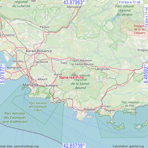
Nans-les-Pins GPS coordinates[2]
43° 22' 14.376" North, 5° 46' 54.804" East
| Map corner | latitude | longitude |
|---|---|---|
| Upper-left | 43.87963°, | 5.07877° |
| Center: | 43.37066°, | 5.78189° |
| Lower-right: | 42.85739°, | 6.48502° |
| Map W x H: | 113.7×113.7 km | = 70.6×70.6mi |
| max Lat: | 51.07786° ⇑94.6% North |
| Nans-les-Pins: | 43.37066° |
| min Lat: | ⇓5.4% South 41.3874° |
| min Long | Nans-les-Pins | max Long |
| -5.08615° | 5.78189° | 9.52242° |
| W 85%⇐ | ⇒15% E |
Elevation
Elevation of Nans-les-Pins is 398 m = 1306 ft, and this is 204.3 m = 670 ft above average elevation for this country.
| Max E: |
2333 m = 7654 ft | 11.4% |
| Nans-les-Pins | 398 m 1306 ft | |
| Avg. | 193.7 m = 635 ft | |
Min E: |
-1 m = -3 ft | 88.6% |
See also: France elevation on elevation.city.
Geographical zone
Nans-les-Pins is located in North temperate zone (between Tropic of Cancer and the Arctic Circle). Distance of this Northern Tropic circle is 2216.4 km =1377.2 mi to South.| Distance of | km | miles | from Nans-les-Pins |
|---|---|---|---|
| North Pole | 5184.7 | 3221.6 | to North |
| Arctic Circle | 2578.8 | 1602.4 | to North |
| Tropic Cancer | 2216.4 | 1377.2 | to South |
| Equator | 4822.4 | 2996.5 | to South |


Nearby cities:
15 places around Nans-les-Pins: (largest is in red/bold)
• Auriol
11.9 km =7.4 mi,  270°
270°
• Cuges-les-Pins
12.4 km =7.7 mi,  212°
212°
• Gémenos
14.8 km =9.2 mi,  236°
236°
• La Destrousse
14.3 km =8.9 mi, 271°
• Mazaugues
11.6 km =7.2 mi,  102°
102°
• Peynier
14.3 km =8.9 mi,  307°
307°
• Plan-d'Aups-Sainte-Baume
6.7 km =4.2 mi,  231°
231°
• Pourcieux
11.1 km =6.9 mi,  1°
1°
• Roquevaire
14.5 km =9 mi,  261°
261°
• Rougiers
6.1 km =3.8 mi,  66°
66°
• Saint-Maximin-la-Sainte-Baume
10.7 km =6.6 mi,  36°
36°
• Saint-Zacharie
6.2 km =3.9 mi,  285°
285°
• Signes
11 km =6.8 mi,  143°
143°
• Tourves
12.2 km =7.6 mi, 70°
• Trets
11.7 km =7.3 mi,  317°
317°
Sources, notices
• [Note1] Compared only with cities in France existing in our database
• [Src1] Map data: © OpenStreetMap contributors (CC-BY-SA)
• [Src2] Other city data from geonames.org with taken over terms of usage.
• [Src3] Geographical zone / Annual Mean Temperature by Robert A. Rohde @ Wikipedia
