Rougiers geodata
Rougiers (Provence-Alpes-Côte d'Azur) is a populated place; located in France in Europe/Paris (GMT+2) time zone. With population of 1,148 people, there are 7838 cities with bigger population in this country. Compared to other cities in France, 94.3% of cities are located further ↑North; 85.6% of cities are located further ←West and 86.3% of cities have lower elevation than Rougiers. Note1
Administrative division(s):
- Level 1: Provence-Alpes-Côte d'Azur
- Level 2: Var
- Level 3: Arrondissement de Brignoles
- Level 4: Rougiers


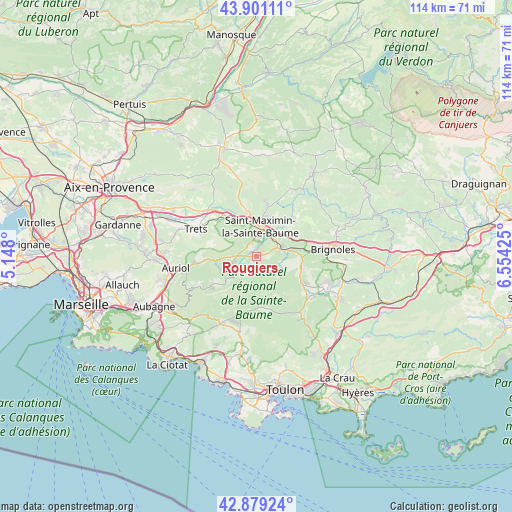
Rougiers GPS coordinates[2]
43° 23' 32.388" North, 5° 51' 4.032" East
| Map corner | latitude | longitude |
|---|---|---|
| Upper-left | 43.90111°, | 5.148° |
| Center: | 43.39233°, | 5.85112° |
| Lower-right: | 42.87924°, | 6.55425° |
| Map W x H: | 113.6×113.6 km | = 70.6×70.6mi |
| max Lat: | 51.07786° ⇑94.3% North |
| Rougiers: | 43.39233° |
| min Lat: | ⇓5.7% South 41.3874° |
| min Long | Rougiers | max Long |
| -5.08615° | 5.85112° | 9.52242° |
| W 85.6%⇐ | ⇒14.4% E |
Elevation
Elevation of Rougiers is 364 m = 1194 ft, and this is 170.3 m = 559 ft above average elevation for this country.
| Max E: |
2333 m = 7654 ft | 13.7% |
| Rougiers | 364 m 1194 ft | |
| Avg. | 193.7 m = 635 ft | |
Min E: |
-1 m = -3 ft | 86.3% |
See also: France elevation on elevation.city.
Geographical zone
Rougiers is located in North temperate zone (between Tropic of Cancer and the Arctic Circle). Distance of this Northern Tropic circle is 2218.9 km =1378.8 mi to South.| Distance of | km | miles | from Rougiers |
|---|---|---|---|
| North Pole | 5182.3 | 3220.1 | to North |
| Arctic Circle | 2576.4 | 1600.9 | to North |
| Tropic Cancer | 2218.9 | 1378.8 | to South |
| Equator | 4824.8 | 2998 | to South |


Nearby cities:
15 places around Rougiers: (largest is in red/bold)
• Bras
12.2 km =7.6 mi,  43°
43°
• La Celle
15.1 km =9.4 mi,  88°
88°
• La Roquebrussanne
11.6 km =7.2 mi,  119°
119°
• Mazaugues
7.5 km =4.7 mi,  130°
130°
• Méounes-lès-Montrieux
15.7 km =9.8 mi,  142°
142°
• Nans-les-Pins
6.1 km =3.8 mi,  246°
246°
• Néoules
15.7 km =9.8 mi, 126°
• Plan-d'Aups-Sainte-Baume
12.7 km =7.9 mi,  238°
238°
• Pourcieux
10.2 km =6.3 mi,  328°
328°
• Pourrières
15.8 km =9.8 mi,  323°
323°
• Saint-Maximin-la-Sainte-Baume
6.3 km =3.9 mi,  7°
7°
• Saint-Zacharie
11.6 km =7.2 mi,  266°
266°
• Signes
11.3 km =7 mi,  175°
175°
• Tourves
6.1 km =3.8 mi,  73°
73°
• Trets
14.9 km =9.3 mi,  294°
294°
Sources, notices
• [Note1] Compared only with cities in France existing in our database
• [Src1] Map data: © OpenStreetMap contributors (CC-BY-SA)
• [Src2] Other city data from geonames.org with taken over terms of usage.
• [Src3] Geographical zone / Annual Mean Temperature by Robert A. Rohde @ Wikipedia
