Mazaugues geodata
Mazaugues (Provence-Alpes-Côte d'Azur) is a populated place; located in France in Europe/Paris (GMT+2) time zone. With population of 636 people, there are 12726 cities with bigger population in this country. Compared to other cities in France, 94.9% of cities are located further ↑North; 86.2% of cities are located further ←West and 93% of cities have lower elevation than Mazaugues. Note1
Administrative division(s):
- Level 1: Provence-Alpes-Côte d'Azur
- Level 2: Var
- Level 3: Arrondissement de Brignoles
- Level 4: Mazaugues


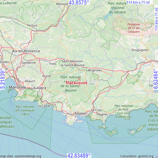
Mazaugues GPS coordinates[2]
43° 20' 54.06" North, 5° 55' 17.472" East
| Map corner | latitude | longitude |
|---|---|---|
| Upper-left | 43.8575°, | 5.21839° |
| Center: | 43.34835°, | 5.92152° |
| Lower-right: | 42.83489°, | 6.62464° |
| Map W x H: | 113.7×113.7 km | = 70.6×70.6mi |
| max Lat: | 51.07786° ⇑94.9% North |
| Mazaugues: | 43.34835° |
| min Lat: | ⇓5.1% South 41.3874° |
| min Long | Mazaugues | max Long |
| -5.08615° | 5.92152° | 9.52242° |
| W 86.2%⇐ | ⇒13.8% E |
Elevation
Elevation of Mazaugues is 503 m = 1650 ft, and this is 309.3 m = 1015 ft above average elevation for this country.
| Max E: |
2333 m = 7654 ft | 7% |
| Mazaugues | 503 m 1650 ft | |
| Avg. | 193.7 m = 635 ft | |
Min E: |
-1 m = -3 ft | 93% |
See also: France elevation on elevation.city.
Geographical zone
Mazaugues is located in North temperate zone (between Tropic of Cancer and the Arctic Circle). Distance of this Northern Tropic circle is 2214 km =1375.7 mi to South.| Distance of | km | miles | from Mazaugues |
|---|---|---|---|
| North Pole | 5187.2 | 3223.2 | to North |
| Arctic Circle | 2581.3 | 1603.9 | to North |
| Tropic Cancer | 2214 | 1375.7 | to South |
| Equator | 4819.9 | 2994.9 | to South |


Nearby cities:
15 places around Mazaugues: (largest is in red/bold)
• Belgentier
13.1 km =8.1 mi,  151°
151°
• Bras
14 km =8.7 mi,  11°
11°
• Brignoles
13 km =8.1 mi,  60°
60°
• Forcalqueiret
13.2 km =8.2 mi,  95°
95°
• Garéoult
10.3 km =6.4 mi, 102°
• La Celle
10.7 km =6.6 mi, 60°
• La Roquebrussanne
4.5 km =2.8 mi, 101°
• Méounes-lès-Montrieux
8.4 km =5.2 mi, 152°
• Nans-les-Pins
11.6 km =7.2 mi,  282°
282°
• Néoules
8.3 km =5.2 mi,  122°
122°
• Rocbaron
13.5 km =8.4 mi,  108°
108°
• Rougiers
7.5 km =4.7 mi,  310°
310°
• Saint-Maximin-la-Sainte-Baume
12.1 km =7.5 mi,  336°
336°
• Signes
8 km =5 mi,  216°
216°
• Tourves
6.6 km =4.1 mi,  1°
1°
Sources, notices
• [Note1] Compared only with cities in France existing in our database
• [Src1] Map data: © OpenStreetMap contributors (CC-BY-SA)
• [Src2] Other city data from geonames.org with taken over terms of usage.
• [Src3] Geographical zone / Annual Mean Temperature by Robert A. Rohde @ Wikipedia
