Saint-Martin-de-Sescas geodata
Saint-Martin-de-Sescas (Nouvelle-Aquitaine) is a populated place; located in France in Europe/Paris (GMT+2) time zone. With population of 519 people, there are 14840 cities with bigger population in this country. Compared to other cities in France, 83% of cities are located further ↑North; 79.3% of cities are located further →East and 93.1% of cities have higher elevation than Saint-Martin-de-Sescas. Note1
Administrative division(s):
- Level 1: Nouvelle-Aquitaine
- Level 2: Gironde
- Level 3: Arrondissement de Langon
- Level 4: Saint-Martin-de-Sescas
Current local time in Saint-Martin-de-Sescas:
02:05 PM, SaturdayDifference from your time zone: hours


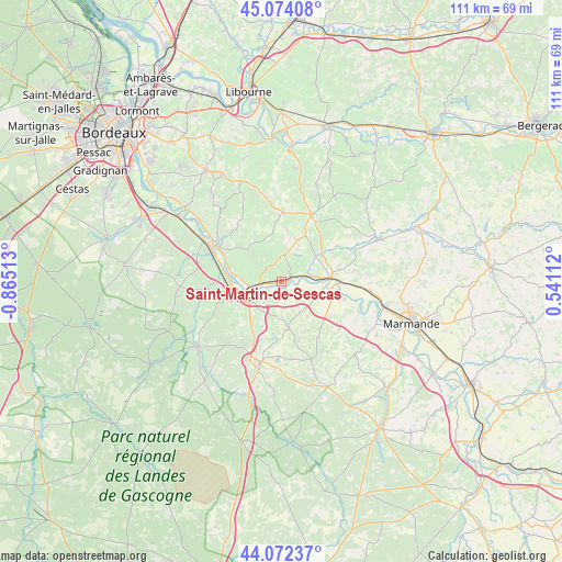
Saint-Martin-de-Sescas GPS coordinates[2]
44° 34' 31.368" North, 0° 9' 43.2" West
| Map corner | latitude | longitude |
|---|---|---|
| Upper-left | 45.07408°, | -0.86513° |
| Center: | 44.57538°, | -0.162° |
| Lower-right: | 44.07237°, | 0.54112° |
| Map W x H: | 111.4×111.4 km | = 69.2×69.2mi |
| max Lat: | 51.07786° ⇑83% North |
| Saint-Martin-de-Sescas: | 44.57538° |
| min Lat: | ⇓17% South 41.3874° |
| min Long | Saint-Martin-de | max Long |
| -5.08615° | -0.162° | 9.52242° |
| W 20.7%⇐ | ⇒79.3% E |
Elevation
Elevation of Saint-Martin-de-Sescas is 22 m = 72 ft, and this is 171.7 m = 563 ft below average elevation for this country.
| Max E: |
2333 m = 7654 ft | 93.1% |
| Avg. | 193.7 m = 635 ft | |
| Saint-Martin-de-Sescas | 22 m = 72 ft | |
Min E: |
-1 m = -3 ft | 6.9% |
See also: France elevation on elevation.city.
Geographical zone
Saint-Martin-de-Sescas is located in North temperate zone (between Tropic of Cancer and the Arctic Circle). Distance of this Northern Tropic circle is 2350.4 km =1460.5 mi to South.| Distance of | km | miles | from Saint-Martin-de-Sescas |
|---|---|---|---|
| North Pole | 5050.7 | 3138.4 | to North |
| Arctic Circle | 2444.9 | 1519.2 | to North |
| Tropic Cancer | 2350.4 | 1460.5 | to South |
| Equator | 4956.3 | 3079.7 | to South |


Nearby cities:
15 places around Saint-Martin-de-Sescas: (largest is in red/bold)
• Auros
9.1 km =5.7 mi,  171°
171°
• Castets-en-Dorthe
1.7 km =1.1 mi,  153°
153°
• Caudrot
1.4 km =0.9 mi,  88°
88°
• Coimères
9.5 km =5.9 mi,  202°
202°
• Gironde-sur-Dropt
6.3 km =3.9 mi,  81°
81°
• Langon
7.4 km =4.6 mi,  250°
250°
• Le Pian-sur-Garonne
4.2 km =2.6 mi,  285°
285°
• Morizès
7 km =4.3 mi,  54°
54°
• Saint-Macaire
5.1 km =3.2 mi,  257°
257°
• Saint-Maixant
7.7 km =4.8 mi,  272°
272°
• Saint-Pierre-d’Aurillac
2.2 km =1.4 mi, 259°
• Sainte-Croix-du-Mont
8.9 km =5.5 mi,  283°
283°
• Savignac
7.3 km =4.5 mi,  144°
144°
• Toulenne
8.3 km =5.2 mi, 255°
• Verdelais
7.1 km =4.4 mi, 282°
Sources, notices
• [Note1] Compared only with cities in France existing in our database
• [Src1] Map data: © OpenStreetMap contributors (CC-BY-SA)
• [Src2] Other city data from geonames.org with taken over terms of usage.
• [Src3] Geographical zone / Annual Mean Temperature by Robert A. Rohde @ Wikipedia
