Toulenne geodata
Toulenne (Nouvelle-Aquitaine) is a populated place; located in France in Europe/Paris (GMT+2) time zone. With population of 2,210 people, there are 4349 cities with bigger population in this country. Compared to other cities in France, 83.1% of cities are located further ↑North; 80.4% of cities are located further →East and 88.3% of cities have higher elevation than Toulenne. Note1
Administrative division(s):
- Level 1: Nouvelle-Aquitaine
- Level 2: Gironde
- Level 3: Arrondissement de Langon
- Level 4: Toulenne


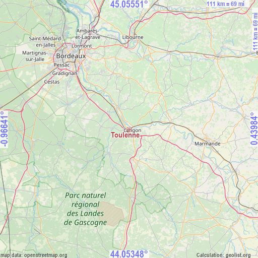
Toulenne GPS coordinates[2]
44° 33' 23.94" North, 0° 15' 47.808" West
| Map corner | latitude | longitude |
|---|---|---|
| Upper-left | 45.05551°, | -0.96641° |
| Center: | 44.55665°, | -0.26328° |
| Lower-right: | 44.05348°, | 0.43984° |
| Map W x H: | 111.4×111.4 km | = 69.2×69.2mi |
| max Lat: | 51.07786° ⇑83.1% North |
| Toulenne: | 44.55665° |
| min Lat: | ⇓16.9% South 41.3874° |
| min Long | Toulenne | max Long |
| -5.08615° | -0.26328° | 9.52242° |
| W 19.6%⇐ | ⇒80.4% E |
Elevation
Elevation of Toulenne is 34 m = 112 ft, and this is 159.7 m = 524 ft below average elevation for this country.
| Max E: |
2333 m = 7654 ft | 88.3% |
| Avg. | 193.7 m = 635 ft | |
| Toulenne | 34 m = 112 ft | |
Min E: |
-1 m = -3 ft | 11.7% |
See also: France elevation on elevation.city.
Geographical zone
Toulenne is located in North temperate zone (between Tropic of Cancer and the Arctic Circle). Distance of this Northern Tropic circle is 2348.3 km =1459.2 mi to South.| Distance of | km | miles | from Toulenne |
|---|---|---|---|
| North Pole | 5052.8 | 3139.7 | to North |
| Arctic Circle | 2446.9 | 1520.4 | to North |
| Tropic Cancer | 2348.3 | 1459.2 | to South |
| Equator | 4954.2 | 3078.4 | to South |


Nearby cities:
15 places around Toulenne: (largest is in red/bold)
• Barsac
7 km =4.3 mi,  323°
323°
• Bommes
7.4 km =4.6 mi,  261°
261°
• Langon
1.2 km =0.7 mi,  109°
109°
• Le Pian-sur-Garonne
5.1 km =3.2 mi,  51°
51°
• Loupiac
7.3 km =4.5 mi,  336°
336°
• Mazères
6.9 km =4.3 mi,  177°
177°
• Preignac
3.9 km =2.4 mi, 321°
• Pujols-sur-Ciron
7.4 km =4.6 mi,  273°
273°
• Roaillan
6.6 km =4.1 mi,  192°
192°
• Saint-Macaire
3.2 km =2 mi,  72°
72°
• Saint-Maixant
2.5 km =1.6 mi,  7°
7°
• Saint-Pierre-d’Aurillac
6.1 km =3.8 mi, 74°
• Sainte-Croix-du-Mont
4.2 km =2.6 mi,  350°
350°
• Sauternes
6.8 km =4.2 mi,  247°
247°
• Verdelais
3.7 km =2.3 mi,  16°
16°
Sources, notices
• [Note1] Compared only with cities in France existing in our database
• [Src1] Map data: © OpenStreetMap contributors (CC-BY-SA)
• [Src2] Other city data from geonames.org with taken over terms of usage.
• [Src3] Geographical zone / Annual Mean Temperature by Robert A. Rohde @ Wikipedia
