Saint-Macaire geodata
Saint-Macaire (Nouvelle-Aquitaine) is a populated place; located in France in Europe/Paris (GMT+2) time zone. With population of 1,775 people, there are 5344 cities with bigger population in this country. Compared to other cities in France, 83% of cities are located further ↑North; 79.9% of cities are located further →East and 93.1% of cities have higher elevation than Saint-Macaire. Note1
Administrative division(s):
- Level 1: Nouvelle-Aquitaine
- Level 2: Gironde
- Level 3: Arrondissement de Langon
- Level 4: Saint-Macaire


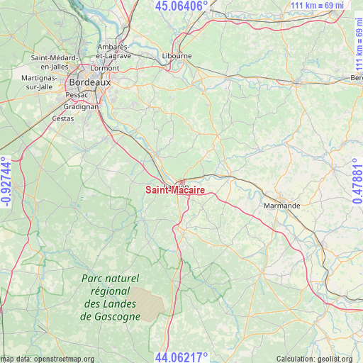
Saint-Macaire GPS coordinates[2]
44° 33' 54.972" North, 0° 13' 27.516" West
| Map corner | latitude | longitude |
|---|---|---|
| Upper-left | 45.06406°, | -0.92744° |
| Center: | 44.56527°, | -0.22431° |
| Lower-right: | 44.06217°, | 0.47881° |
| Map W x H: | 111.4×111.4 km | = 69.2×69.2mi |
| max Lat: | 51.07786° ⇑83% North |
| Saint-Macaire: | 44.56527° |
| min Lat: | ⇓17% South 41.3874° |
| min Long | Saint-Macaire | max Long |
| -5.08615° | -0.22431° | 9.52242° |
| W 20.1%⇐ | ⇒79.9% E |
Elevation
Elevation of Saint-Macaire is 22 m = 72 ft, and this is 171.7 m = 563 ft below average elevation for this country.
| Max E: |
2333 m = 7654 ft | 93.1% |
| Avg. | 193.7 m = 635 ft | |
| Saint-Macaire | 22 m = 72 ft | |
Min E: |
-1 m = -3 ft | 6.9% |
See also: France elevation on elevation.city.
Geographical zone
Saint-Macaire is located in North temperate zone (between Tropic of Cancer and the Arctic Circle). Distance of this Northern Tropic circle is 2349.3 km =1459.8 mi to South.| Distance of | km | miles | from Saint-Macaire |
|---|---|---|---|
| North Pole | 5051.9 | 3139.1 | to North |
| Arctic Circle | 2446 | 1519.9 | to North |
| Tropic Cancer | 2349.3 | 1459.8 | to South |
| Equator | 4955.2 | 3079 | to South |


Nearby cities:
15 places around Saint-Macaire: (largest is in red/bold)
• Barsac
8.6 km =5.3 mi,  303°
303°
• Castets-en-Dorthe
5.7 km =3.5 mi,  94°
94°
• Caudrot
6.5 km =4 mi,  79°
79°
• Coimères
7.7 km =4.8 mi,  170°
170°
• Langon
2.4 km =1.5 mi,  235°
235°
• Le Pian-sur-Garonne
2.4 km =1.5 mi,  21°
21°
• Loupiac
8.3 km =5.2 mi,  313°
313°
• Mazères
8.3 km =5.2 mi,  199°
199°
• Preignac
5.9 km =3.7 mi,  290°
290°
• Saint-Maixant
3.1 km =1.9 mi, 298°
• Saint-Martin-de-Sescas
5.1 km =3.2 mi, 77°
• Saint-Pierre-d’Aurillac
2.9 km =1.8 mi, 75°
• Sainte-Croix-du-Mont
4.9 km =3 mi, 310°
• Toulenne
3.2 km =2 mi,  252°
252°
• Verdelais
3.3 km =2.1 mi,  322°
322°
Sources, notices
• [Note1] Compared only with cities in France existing in our database
• [Src1] Map data: © OpenStreetMap contributors (CC-BY-SA)
• [Src2] Other city data from geonames.org with taken over terms of usage.
• [Src3] Geographical zone / Annual Mean Temperature by Robert A. Rohde @ Wikipedia
